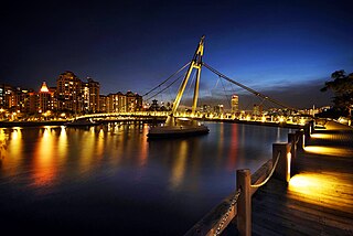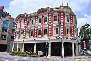
Kallang is a planning area and residential town located in the Central Region of Singapore.

The Singapore River is a river that flows parallel to Alexandra Road and feeds into the Marina Reservoir in the southern part of Singapore. The immediate upper watershed of the Singapore River is known as the Singapore River Planning Area, although the western part of the watershed is classified under the River Valley planning area.

Raffles Place is the centre of the Financial District of Singapore and is located south of the mouth of the Singapore River. It was first planned and developed in the 1820s as Commercial Square to serve as the hub of the commercial zone of Singapore in Raffles Town Plan. It was renamed Raffles Place in 1858 and is now the site of a number of major banks. It is located in the Downtown Core within the Central Area, and features some of the tallest buildings and landmarks of the country.

The Downtown Core is the historical and downtown centre of the city-state of Singapore and the main commercial area in Singapore excluding reclaimed lands with many integrated resorts such as the Marina Bay Sands, one of the most expensive buildings in the world, with a luxurious standalone casino at Bayfront Avenue. There are many skyscrapers in Raffles Place, Tanjong Pagar and Marina Bay CBD with a height limit of 280m. It is one of the eleven planning areas located within the most urbanised Central Area, forming the latter's dense urban core. It is bounded by Rochor to the north, Kallang to the northeast, Marina East and Marina South to the east, Straits View to the southeast, Bukit Merah to the south, as well as Outram, Museum and Singapore River to the west.

The Padang is an open playing field located within the Downtown Core of the Central Area in Singapore. It includes the Padang Cricket Ground. The Padang is surrounded by several important landmarks, which include Saint Andrew's Cathedral, City Hall, the Old Supreme Court Building and the City Hall MRT station.

Kallang Basin is an enclosed bay in Kallang, Singapore. The Kallang River, Rochor River and Geylang River empty into the Kallang Basin. The Marina Channel connects the Kallang Basin with the Singapore Straits.

Shenton Way is a major trunk road serving Singapore's Central Area and is most commonly known for the commercial skyscrapers flanking both sides of the road. The road is a one-way street that starts at the junction of Boon Tat Street, Raffles Quay and Commerce Street before ending at Keppel Road.

Raffles's Landing Site is the location where tradition holds that Sir Stamford Raffles landed in on 28 January 1819. The site is located at Boat Quay within the Civic District, in the Downtown Core of the Central Area, Singapore's central business district.

Marina Central or Marina Centre is a zone of reclaimed land within the Downtown Core in the southern part of Singapore. Together with the Marina South area, it encloses the sheltered Marina Bay.

Collyer Quay is a road in Downtown Core, Singapore that starts after Fullerton Road and ends at the junction of Raffles Quay, Finlayson Green and Marina Boulevard. The road houses several landmarks namely, Clifford Pier, Change Alley, Hitachi Tower, Ocean Towers and Ocean Financial Centre.

North Bridge Road is a one-way road in Singapore, running north of the Singapore River. It starts at the junction with Crawford Street in Kallang, on the western bank of the Rochor River, and continues in a southwest direction before ending at Elgin Bridge. The stretch south of the Singapore River after Elgin Bridge is called South Bridge Road. En route, North Bridge Road travels through the planning areas of Kallang, Rochor and the Downtown Core.

Cross Street is a street in Singapore starting from Shenton Way in Downtown Core and ending at the junction of South Bridge Road in Chinatown which is in Outram Planning Area which then becomes Upper Cross Street. At the start of the street, it houses Telok Ayer Market. A number of landmarks are located on the street including Far East Square and China Square Central.

Bras Basah Road is a one-way road in Singapore in the planning areas of Museum and Downtown Core. The road starts at the junction of Orchard Road and Handy Road, at the ERP gantry towards the Central Business District, and ends at the junction with Nicoll Highway, beyond which it becomes Raffles Boulevard. Several landmarks including Fairmont Singapore, Raffles Hotel, Singapore Art Museum, Cathedral of the Good Shepherd and the Singapore Management University are located along the road. A MRT station with the same name, Bras Basah MRT station, is on the Circle Line.

Stamford Road is a one-way road in Singapore within the planning areas of Downtown Core and Museum. The road continues after the traffic light junction of Nicoll Highway, Esplanade Drive and Raffles Avenue towards Orchard Road. It then ends at the junction of Fort Canning Road, Bencoolen Street and Orchard Road, which it continues to be Orchard Road. Stamford Road is home to several landmarks, including Swissôtel The Stamford and the National Museum of Singapore.

The Museum Planning Area is a planning area located in the Central Area of the Central Region of Singapore. The area plays a "bridging role" between the Orchard area and the Downtown Core, which necessitates proper transport networks for vehicles, pedestrians and public transport. Due to the sheer size of green areas in the district, the Urban Redevelopment Authority (URA) has designated it a 'green lung' in the Central Area. However, the Museum Planning Area is also home to cultural and commercial activities. Around 65% of the area is available for future development, making it a hotbed for new infrastructure and buildings.

Nicoll Highway is a major arterial road in Singapore which links the junctions of Guillemard Road, Sims Way and Mountbatten Road in Kallang to the junctions of Esplanade Drive, Raffles Avenue and Stamford Road in the city. En route, it passes through the areas of Kallang, Kampong Glam and Marina Centre.

Golden Mile Complex is a high-rise commercial and residential building on Beach Road in Kallang, Singapore, within walking distance to Nicoll Highway MRT station. The building was formerly known as Woh Hup Complex. The complex contains 411 shops and 500 parking spaces. The building is largely an ethnic enclave for the Thai population in Singapore.
Swan & Maclaren Architects is a Singaporean architectural and industrial design firm. One of the oldest architectural firms in the country, it was formerly known as Swan & Maclaren and Swan & Lermit, and was one of the most prominent architectural firms in Singapore when it was a crown colony during the early 20th century.

Stamford House is a historic building located at the corner of the junction of Stamford Road and Hill Street, in the Downtown Core of Singapore. Originally known as Oranje Building, it formerly housed a shopping mall. The building had since redeveloped along with adjoined Capitol Building and both were reopened as a hotel The Capitol Kempinski Hotel Singapore in October 2018.

Crawford is a subzone within the planning area of Kallang, Singapore, as defined by the Urban Redevelopment Authority (URA). Its perimeter is made up of Rochor River and Rochor Canal in the north; Crawford Street, Nicoll Highway, Kallang Basin and Marina Channel in the east; East Coast Parkway (ECP) in the south; as well as Ophir Road, Beach Road and Jalan Sultan in the west.


