Bear Flat

Last updated

Bear Flat
Bear Flat, Bath, from Holloway.jpg
Somerset UK location map.svg
Red pog.svg
Bear Flat
Location within Somerset
OS grid reference ST745638
Unitary authority
Ceremonial county
Region
Country England
Sovereign state United Kingdom
Post town BATH
Postcode district BA2
Dialling code 01225
Police Avon and Somerset
Fire Avon
Ambulance South Western
UK Parliament
List of places
UK
England
Somerset
51°22′26″N2°22′00″W / 51.3738°N 2.3666°W / 51.3738; -2.3666 Coordinates: 51°22′26″N2°22′00″W / 51.3738°N 2.3666°W / 51.3738; -2.3666

Bear Flat is a neighbourhood within the city of Bath, Somerset, England, to the south of the city centre and to the west of Beechen Cliff (a heavily wooded escarpment on the northern side of Lyncombe Hill which features in Jane Austen's Northanger Abbey). It forms the southern part of the Widcombe and Lyncombe electoral ward. The Wellsway road (A367) to Shepton Mallet, runs through Bear Flat, forming part of the ancient British Roman Fosse Way. This was originally the main pilgrimage route from Bath and its abbey, to the nearby ecclesiastical centres of Wells and Glastonbury.

Contents

Bath is a hilly city and the term 'Flat' may be derived from the way the district is defined by a short plateau at the top of the steep Wells Road and Holloway routes out of the city centre, which forms the local business district. 'Bear' has nothing to do with the animal but is believed to be a contraction of an Anglo-Saxon name 'Berewick' - 'Bere' meaning Barley and 'Wick' being a settlement - a settlement near a barley field. [1] Such a field would have been part of Barrack Farm, which was located in the area but demolished in the 19th century to make way for housing. Physical evidence of the former farm exists at the top of the Wellsway at Odd Down with a pair of houses known as Barrack Farm Cottages.

Location

In reaching Bear Flat from the centre of Bath, the original route was up the steep lane of Holloway (either the 'holy way', or a way hollowed out as it climbs around the shoulder of Lyncombe Hill). Holloway was a possible southern route of the Fosse Way out of Bath and has a 14th-century pilgrims' church, the Magdalen Chapel and well (recently restored but without water). To the north of the chapel is the eighteenth century Magdalen Cottage, a former leper hospital but now a private dwelling. In the nineteenth century, another route out of the city centre to Bear Flat was constructed, an early example of a by-pass with slightly gentler slope. Now called Wells Road, the route was named on some early maps simply as the Wells-Exeter Road. Holloway has been closed to traffic at the northern end since the late 1960s, when the area was extensively and quite controversially redeveloped during a period in the immediate post war decades known as The Sack of Bath. Vehicles now take the Wells Road out of Bath towards Radstock, while pedestrians and cyclists can still follow Holloway up the hill.

At the top of Lyncombe Hill to the east of Bear Flat is Alexandra Park, which affords fine views over the city. This was opened in 1903 and named in honour of Queen Alexandra. Alongside Alexandra Park is Beechen Cliff School. Further to the east runs the Widcombe valley, once a parish outside the city of Bath. It is characterised by its Georgian buildings. To the south is the deep wooded valley of Lyncombe Vale. This was formerly the route of the Bath branch of the Somerset and Dorset Railway, and the Combe Down Tunnel which at 1700 metres in length was reputed to be the longest unventilated rail tunnel in Britain. This tunnel, together with the shorter Devonshire Tunnel, were both reopened as part of the Two Tunnels Greenway on 6 April 2013 forming part of the National Cycle Network NCR244.

Geography

Buildings and Services

The Bear pub in 2010 The Bear, Bear Flat, Bath.jpg
The Bear pub in 2010
Beechen Cliff Methodist Church Beechen Cliff Methodist Church - geograph.org.uk - 940589.jpg
Beechen Cliff Methodist Church

The Georgians built at either end of Bear Flat: at Devonshire Buildings to the south, and Beechen Cliff to the north. The main estate of Poets' Corner is a late Victorian and Edwardian district of large terraced houses and forms a part of the wider City of Bath conservation area. Poets' Corner comprises four avenues (Shakespeare, Milton, Kipling and Longfellow), which all lead directly perpendicular from the Wellsway) with Chaucer Road running through the estate parallel to Wellsway. Other 'Poet' locations include Byron Road and Shelley Road. Other streets include Devonshire Place, Attewell Place (formerly Cross's Yard) and Greenway Court.

The area at the top of the hill where the Wells Road meets Holloway and becomes the Wellsway has been a local commercial centre for some time. Before the Second World War it included various shops including a bank and a chemist. During the Second World War, Bear Flat was targeted in the 'Baedeker' raids on the city of Bath, and damage was done to the area near the junction of the Wellsway and Holloway. Images can be seen at The Bath Blitz Memorial Site. Some of the modern shops are in premises that have been rebuilt since the war.

Bear Flat still has a range of shops, including a small Co-operative supermarket, Andrews estate agents, a branch of Carphone Warehouse, Majestic Wine, Da Vinci's delicatessen, and various other businesses including a chemist, hairdresser, barber, florist and a charity shop. Rolfeys Antique shop closed in 2019 [2]

For people who wish to eat in Bear Flat there is a cafe, a fish and chip shop, a Tandoori restaurant, Menu Gordon Jones, whose owner/chef has gained both local and national accolades, [3] Da Vinci also provides coffee and lunch. There are also two public houses; The Bear which comprises a restaurant and now provides accommodation [4] and the more traditional Devonshire Arms, which also serves food, has numerous sporting attractions including a traditional skittle alley and provides venue space. [5] The Bear pub was formerly a brewery and public house but was severely damaged by a bomb in the Second World War and subsequently demolished - the current pub is post-war and features a large polar bear on its front roof which has become the emblem for the Bear Flat Association. [6]

The Beechen Cliff Methodist Church, built in 1905, [7] is located at the bottom of Shakespeare Avenue, with Bruton Community Hall, the home of the monthly Bear Flat Community Market and the Bear Flat Pre-school located at the rear in Bruton Avenue. There are a number of bed and breakfast businesses attracted by the convenient access to the city centre, together with a double glazing showroom and building company on the east side of the Wellsway.

Bear Flat Artists

Each year a large group of local artists and crafts people, including painters, potters/ceramicists, sculptors, jewellers and photographers organise an Open Studios event over the Spring Bank Holiday weekend. Numerous homes are opened to the public during this weekend and The Bear Hotel provides space for the artists to display their work, much of this work is also for sale. [8]

Related Research Articles

Islington Area of London

Islington is a district in Greater London, England, and part of the London Borough of Islington. It is a mainly residential district of Inner London, extending from Islington's High Street to Highbury Fields, encompassing the area around the busy High Street, Upper Street, Essex Road, and Southgate Road to the east.

A4 road (England) major road in England

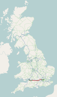
The A4 is a major road in England from Central London to Avonmouth via Heathrow Airport, Reading, Bath and Bristol. It is historically known as the Bath Road with newer sections including the Great West Road and Portway. The road was once the main route from London to Bath, Bristol and the west of England and formed, after the A40, the second main western artery from London.

Downham Human settlement in England

Downham is a district of south-east London, England, within the London Borough of Lewisham. It borders the London Borough of Bromley, and is located north of Bromley and south of Catford.

Northfield, Birmingham Human settlement in England

Northfield is a small town and also a small residential area on the southern outskirts of metropolitan Birmingham, England, and near the boundary with Worcestershire. It is also a council constituency, managed by its own district committee. The constituency includes the wards of Kings Norton, Longbridge, Weoley Castle and the smaller ward of Northfield that includes West Heath and Turves Green.

Beechen Cliff School Academy in Bath, Somerset, England

Beechen Cliff School is a boys' secondary school in Bath, Somerset, England, with about 1,150 pupils. Its earliest predecessor school was founded in 1896.

Walderslade Human settlement in England

Walderslade is a large suburb in Kent to the south of Chatham split between the unitary authority of Medway and the boroughs of Maidstone and Tonbridge & Malling in South East England. It was, until 1998, fully part of Kent and is still ceremonially associated via the Lieutenancies Act. It encompasses almost all the ME5 postcode district.

Midford Human settlement in England

Midford is a village approximately 3 miles (5 km) south-south-east of Bath, Somerset, England. Although relatively small, it extends over 2 counties, is part of two unitary authorities and is part of five parishes. Although all five parishes extend very near to the village centre, most of the residents reside in the parish of Southstoke and are part of the Bath and North East Somerset unitary authority.

Weston, Bath Human settlement in England

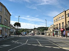
Weston is a suburb and electoral ward of Bath in England, located in the northwest of the city. Originally a separate village, Weston has become part of Bath as the city has grown, first through the development of Lower Weston in Victorian times and then by the incorporation of the village into the city, with the siting of much local authority housing there in the period after World War II.

Parkstone Human settlement in England

Parkstone is an area of Poole, Dorset. It is divided into 'Lower' and 'Upper' Parkstone. Upper Parkstone - "Up-on-'ill" as it used to be known in local parlance - is so-called because it is largely on higher ground slightly to the north of the lower-lying area of Lower Parkstone - "The Village" - which includes areas adjacent to Poole Harbour.

Museum of Bath Architecture

The Museum of Bath Architecture in Bath, Somerset, England, occupies the Countess of Huntingdon's Chapel, where it provides exhibits that explain the building of the Georgian era city during the 18th century.

Two Tunnels Greenway

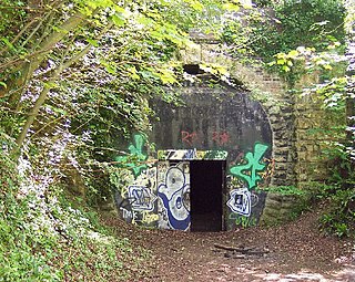
The Two Tunnels Greenway is a shared use path for walking and cycling in Bath, Somerset, England. The route is National Cycle Route 244. The route joins National Cycle Route 24 south of Bath, with National Cycle Route 4 which runs through Bath.

Districts of Redditch Human settlement in England

Redditch is a town and local government district in north-east Worcestershire, England. The town is divided into separate districts. All street-name signs in Redditch have the street name in white lettering on a blue background and the district name in black lettering on a white background at the bottom of the sign. In the New Town areas the roads are usually named in alphabetical order and house numbering in the cul-de-sac closes is consecutive, starting with number 1 as the first house on the left as you enter, and the highest house number will be on the opposite side of the road as you leave.

St Thomas à Becket Church, Widcombe Church

St Thomas à Becket Church is a parish church of Widcombe in Bath, Somerset southwest England, and is one of a number of churches named after Thomas Becket. It is a Grade II* listed building.

Widcombe, Bath Human settlement in England

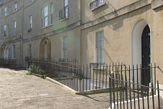
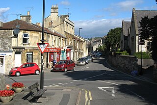
Widcombe is a district of Bath, England, immediately south-east of the city centre, across the River Avon.

Buildings and architecture of Bath Permanent structures including significant examples of English architecture from the Roman Baths

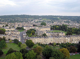
The buildings and architecture of Bath, a city in Somerset in the south west of England, reveal significant examples of the architecture of England, from the Roman Baths, to the present day. The city became a World Heritage Site in 1987, largely because of its architectural history and the way in which the city landscape draws together public and private buildings and spaces. The many examples of Palladian architecture are purposefully integrated with the urban spaces to provide "picturesque aestheticism". It is the only entire city in Britain to achieve World Heritage status, and is a popular tourist destination.

Bath Abbey Cemetery cemetery in Bath and North East Somerset, UK

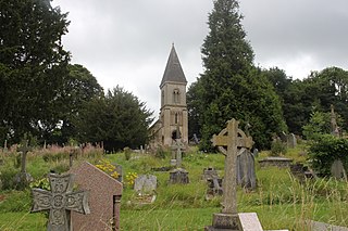
The Anglican Bath Abbey Cemetery, officially dedicated as the Cemetery of St Peter and St Paul, was laid out by noted cemetery designer and landscape architect John Claudius Loudon (1783–1843) between 1843 and 1844 on a picturesque hillside site overlooking Bath, Somerset, England.

Kingsmead, Bath Human settlement in England

Kingsmead is an electoral ward within Bath, England, which encompasses most of Bath city centre and stretches west along the A4 to meet Newbridge and Weston wards. The ward elects two councillors to the Bath and North East Somerset unitary authority.

Lyncombe, Bath Human settlement in England

Lyncombe is a district and electoral ward in Bath, Somerset, and a former parish in the Diocese of Bath and Wells. In the mid-19th century the parish was formed when the parish of Widcombe and Lyncombe was split in two, but it was abolished in the late 1960s. The village of Lyncombe existed since at least the Saxon period prior to becoming part of the City of Bath.

Smallcombe Cemetery

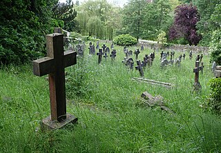
Smallcombe Cemetery is situated on the edge of Bath, Somerset, England, in a valley between Widcombe Hill and Bathwick Hill. The cemetery consists of two distinct parts, the Anglican section known as St Mary's Churchyard and the non-conformist section known as Smallcombe Vale cemetery. They are sometimes known together as Smallcombe Garden cemetery. The two cemeteries have been closed to new burials since 1988 and they are maintained by Bath and North East Somerset Council. The Bath Corporation assumed responsibility for both cemeteries in 1947. In 1977 the caretakers lodge, described as The Lodge, Bathwick Cemetery, BA2 6DD, was sold for £800 without water or drainage.

References

  1. Keevil, A.J. (2000). Barrack(s) Farm, Wellsway, Bath: The Estate and Its Holders (PDF). Bath Archaeological Trust in association with Millstream Books. ISBN   0-948975-61-X.
  2. "Bath antique shop owner who started business as dying wish after cancer diagnosis says he has lived '20 years longer than he thought'". January 2019.
  3. http://www.menugordonjones.co.uk
  4. http://www.bearbath.co.uk/
  5. http://www.devonshire-arms-bath.co.uk
  6. http://www.bearflat.org.uk
  7. "A Brief History of Bath Methodism and Beechen Cliff Methodist Church" (PDF). September 2014.
  8. Bear Flat Artists