Bedford Level Corporation

Last updated

The Bedford Level Corporation (or alternatively the Corporation of the Bedford Level) was founded in England in 1663 to manage the draining of the Fens of East Central England. It formalised the legal status of the Company of Adventurers previously formed by the Duke of Bedford to reclaim 95,000 acres of the Bedford Level.

Contents

History

The low-lying land of East Central England, known as the Fens, consisted traditionally of semi-continuous marshland and peat bog interspersed with isolated patches of higher ground. Agriculture has only been made possible by a co-ordinated system of drainage ditches. During medieval times this was controlled by the great monasteries in the area but fell into disrepair after the dissolution of the monasteries. By the 1600s the general drainage situation was so bad that King James I invited Cornelius Vermuyden, the Dutch engineer, to devise a scheme to drain the Great Fen.

Map of eastern England, showing position of the Fens Map of the Fens.svg
Map of eastern England, showing position of the Fens

The Bedford Level

The Great Fen, lying between the Wash and Cambridge, is more popularly known as the Bedford Level after Francis Russell, 4th Earl of Bedford, who owned a large part of it. It covers some 300,000 acres in the historical counties of Northamptonshire, Norfolk, Suffolk, Lincolnshire, Cambridgeshire and Huntingdonshire and much of it lies below sea level. It was divided under Vermuyden's plan into three areas, North, Middle and South Level.

The Company of Adventurers

Following the king's initiative The Duke of Bedford was asked to undertake to free the Bedford Level from flooding as an alternative to giving the project to Vermuyden. In 1630 he agreed a contract with the Commissioners of Sewers (who were responsible for fenland drainage) which was known as the "Lynn Law" after the town of King's Lynn where it was drawn up. The earl and his 12 associates, known as adventurers (i.e. venture capitalists), contracted to drain the southern part of the fens within six years in return for 95,000 acres of the reclaimed land. 12,000 acres would go to the king and 80,000 would be allocated amongst the adventurers in proportion to their financial investment. The latter would be in terms of £500 shares, 20 in all. The shares were wholly and partly transferable and thus the list of shareholders changed and grew. Charges on the land reclaimed would fund maintenance and future development. The constitution and the rights to levy charges was confirmed by royal charter in the name of Charles I. [1]

The original adventurers were: [2]

NameSharesAllocation (acres)Notes
Francis Russell, 4th Earl of Bedford 28,000
Sir Miles Sandys, 1st Baronet 28,000
Sir William Russell 28,000MP, of Chippenham, Cambridgeshire. Commissioner of Sewers for Great Fen
William Tyringham 28,000MP, of Tyringham, Buckinghamshire
Anthony Hamond 28,000of Saint Albons, Kent
Oliver St John, 1st Earl of Bolingbroke 14,000
Edward, Baron Gorges of Dundalk 14,000
Sir Robert Heath 14,000Chief Justice of Common Plea
Sir Robert Bevill 14,000MP for Huntingdonshire in 1621, Commissioner of Sewers, Great Fen
Sir Philibert Vernatti 14,000of Carleton, Yorkshire
William Sams, LLD14,000Commissioner of Sewers
Samuel Spalding14,000of Cambridge
Andrewes Burrell14,000of London, Commissioner of Sewers
Sir Robert Lovett14,000of Liscombe Park, Buckinghamshire
??14,000
Total2080,000
New Bedford River at Sutton Gault New Bedford River, Sutton Gault (geograph 5497362).jpg
New Bedford River at Sutton Gault

Work got underway to dig several major new ditches and install sluices at the mouths of river to hold back the high tides. In particular a straight cut (now known as the Old Bedford River) was made in the Cambridgeshire Fens to join the River Great Ouse to the sea at King's Lynn. Many of these works had been sought by the Commissioners of Sewers for generations but lack of power and resources had prevented their implementation.

As time went by and construction costs rose it became clear that the adventurers company organisation was unsuitable for such a longterm project, beset as it was with issues of collecting charges and navigation interests. The fact that its legality only stemmed from a royal charter was another major problem. In 1638 the king revoked the contract, allocating 40,000 acres to the Company of Adventurers and taking over as undertaker of the project himself. In 1640 Vermuyden was asked to take on the management of the work but by 1642 the political landscape had changed. The Civil War intervened and the project came to a halt until Vermuyden was able to resume work under parliamentary control in 1649 under the terms and conditions of what came to be called the "Pretended Act". He created the New Bedford River, also known as the Hundred Foot Drain (from its width), which ran parallel to the Old Bedford River with a flood plain (the Ouse Washes) between the two.

By this time Parliament had taken over much of the king's former authority and was deemed necessary and desirable to reincorporate the company via an Act of Parliament in order to satisfactorily manage the completion and maintenance of the scheme. [1]

Creation of the Bedford Level Corporation

Great Level of the Fens Drainage Act 1660
Act of Parliament
Coat of Arms of England (1660-1689).svg
Long title An Act for the necessary Maintenance of the Work of Draining the Great Level of the Fens.
Citation 12 Cha. 2. c. 2
Dates
Royal assent 13 September 1660
Other legislation
Amended byGreat Level of the Fens Drainage Act 1661
Great Level of the Fens Drainage Act 1661
Act of Parliament
Coat of Arms of England (1660-1689).svg
Long title An Act for confirming and continuing an Act, for the necessary Maintenance of the Work of draining the Great Level of the Fens.
Citation 13 Cha. 2. St. 1. c. 14
Dates
Royal assent 30 July 1661
Other legislation
AmendsGreat Level of the Fens Drainage Act 1660
Bedford Level Act 1663
Act of Parliament
Coat of Arms of England (1660-1689).svg
Long title An Act for settling the dreyning of the Great Levell of the Fenns called Bedford Levell.
Citation 15 Cha. 2. c. 17
Dates
Royal assent 27 July 1663
Commencement 18 February 1663
Other legislation
Amended byBedford Level Act 1685
Text of statute as originally enacted
Bedford Level Act 1667
Act of Parliament
Coat of Arms of England (1660-1689).svg
Long title An Act for the taxing and assessing of the Lands of the Adventurers within the Great Levell of the Fenns.
Citation 19 & 20 Cha. 2. c. 13
  • (Ruffhead: 19 Cha. 2. c. 8)
Dates
Royal assent 9 May 1668
Text of statute as originally enacted
Bedford Level Act 1685
Act of Parliament
Coat of Arms of England (1660-1689).svg
Long title An Act for repealing a Clause for dividing of Commons, in an Act of Parliament made in the 15th Year of King Charles the Second, intituled, "An Act for settling the Draining of the Great Level of the Fens, called Bedford Levell."
Citation 1 Ja. 2. c. 2
Dates
Royal assent 27 June 1685
Other legislation
AmendsBedford Level Act 1663

Following the restoration of Charles II in 1660, a series of local acts were passed to enable the project to advance.

The Bedford Level Corporation was created by the General Drainage Act 1663 (15 Cha. 2. c. 17) which received royal assent on 27 July 1663. The corporation's general objectives remained unchanged but its powers in respect of navigation rights and taxation were much improved. The organisation was to comprise a governor, six bailiffs, 20 conservators and the commonalty. The first meeting took place at the Fen Office in the Inner Temple, London on 1 August 1663, where the various official were elected. [3]

The first governor was William Russell, 1st Duke of Bedford, son of the original Undertaker, who held the position until his death in 1700, when he was replaced by his grandson Wriothesley Russell, 2nd Duke of Bedford. On the 2nd Duke's death in 1711 the post devolved to his young son Wriothesley Russell, 3rd Duke of Bedford, a child of only 3 years of age, who nevertheless served as governor for 21 years, dying in 1732. He was followed by his younger brother, John Russell, 4th Duke of Bedford and on the 4th Duke's death in 1771 by the latter's 5 year old grandson Francis Russell, 5th Duke of Bedford, who then served for 31 years. He was succeeded in 1802 by his brother John Russell, 6th Duke of Bedford.

Some of the notable bailiffs were: [3]

Work of the corporation

The windpump at Wicken Fen Wicken Fen Windpump.jpg
The windpump at Wicken Fen
A typical Fenland sluice where the River Delph joins the New Bedford River Welmore Lake Sluice - geograph.org.uk - 2734068.jpg
A typical Fenland sluice where the River Delph joins the New Bedford River

As the drainage succeeded in its general purpose, albeit with many technical difficulties, the level of the land sank as it dried out, negating the achievement. It was then decided to introduce several hundred windpumps to lift the water from the fields into the drainage ditches and rivers. The windpumps were replaced with first steam-powered and later diesel-powered pumps.

The system also depended on a number of sluices (locks) to prevent flooding at high tide or to control the flow of water within the system. These required constant maintenance and repair. Other ongoing problems concerned silting and navigation issues such as towpaths and access.

Relocation and devolution of the corporation

In 1843 the corporation's headquarters were moved to Bedford House, Ely. The three original divisions became self-governing:

The corporation's powers and responsibilities gradually reduced until in 1920 it was finally wound up when its powers and responsibilities were transferred to the Ouse Drainage Board. This in turn became part of the River Great Ouse Catchment Board in 1930.

See also

Related Research Articles

<span class="mw-page-title-main">River Great Ouse</span> River in England

The River Great Ouse is a river in England, the longest of several British rivers called "Ouse". From Syresham in Northamptonshire, the Great Ouse flows through Buckinghamshire, Bedfordshire, Cambridgeshire and Norfolk to drain into the Wash and the North Sea near Kings Lynn. Authorities disagree both on the river's source and its length with one quoting 160 mi (260 km) and another 143 mi (230 km). Mostly flowing north and east, it is the fifth longest river in the United Kingdom. The Great Ouse has been historically important for commercial navigation, and for draining the low-lying region through which it flows; its best-known tributary is the Cam, which runs through Cambridge. Its lower course passes through drained wetlands and fens and has been extensively modified, or channelised, to relieve flooding and provide a better route for barge traffic. The unmodified river would have changed course regularly after floods.

<span class="mw-page-title-main">River Little Ouse</span> River in east England

The River Little Ouse, also known as the Brandon River, is a river in the east of England, a tributary of the River Great Ouse. For much of its length it defines the boundary between Norfolk and Suffolk.

<span class="mw-page-title-main">The Fens</span> Natural region on the east coast of England

The Fens or Fenlands in eastern England are a naturally marshy region supporting a rich ecology and numerous species. Most of the fens were drained centuries ago, resulting in a flat, dry, low-lying agricultural region supported by a system of drainage channels and man-made rivers and automated pumping stations. There have been unintended consequences to this reclamation, as the land level has continued to sink and the dykes have been built higher to protect it from flooding.

<span class="mw-page-title-main">Old Bedford River</span> Watercourse in Cambridgeshire, England

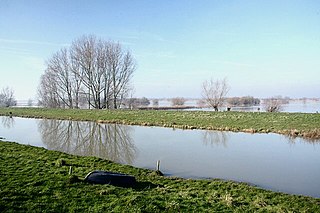
The Old Bedford River is an artificial, partial diversion of the waters of the River Great Ouse in the Fens of Cambridgeshire, England. It was named after the fourth Earl of Bedford who contracted with the local Commission of Sewers to drain the Great Level of the Fens beginning in 1630. It provided a steeper and shorter path for the waters of the Great Ouse, and was embanked to prevent them flooding the low ground of the South Fens. Throughout the project, the Earl and his Adventurers faced disruption from those who were opposed to drainage schemes. The project was deemed to have succeeded in draining the fens in 1637, but that decision was reversed in 1638. After a lull during the English Civil War, when much of the work was damaged, the Dutch engineer Cornelius Vermuyden worked with William Russell, the fifth Earl of Bedford to complete the drainage. Disruption and unrest continued while the work was carried out, resulting in the Adventurers employing armed guards. A second river, the New Bedford River, was cut parallel to the first channel, which then became the Old Bedford River. At some point, the Old Bedford River was split into two parts, when the upper section was diverted into the River Delph at Welches Dam, and the lower section was joined to the Counter Drain. Both parts retain the name, but are not connected to each other. The area between the two Bedford rivers acts as a large washland, which holds floodwater when the river channels cannot cope with the volume of water in them.

<span class="mw-page-title-main">New Bedford River</span> Watercourse in Cambridgeshire, England

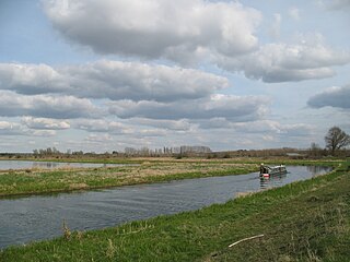
The New Bedford River, also known as the Hundred Foot Drain because of the distance between the tops of the two embankments on either side of the river, is a navigable man-made cut-off or by-pass channel of the River Great Ouse in the Fens of Cambridgeshire, England. It provides an almost straight channel between Earith and Denver Sluices. It is tidal, with reverse tidal flow being clearly visible at Welney, some 19 miles (31 km) from the sea.

<span class="mw-page-title-main">Ouse Washes</span> Nature reserve in the United Kingdom

Ouse Washes is a linear 2,513.6-hectare (6,211-acre) biological Site of Special Scientific Interest stretching from near St Ives in Cambridgeshire to Downham Market in Norfolk. It is also a Ramsar internationally important wetland site, a Special Protection Area for birds, a Special Area of Conservation and a Nature Conservation Review site, Grade I. An area of 186 hectares between March and Ely is managed by the Wildlife Trust for Bedfordshire, Cambridgeshire and Northamptonshire and another area near Chatteris is managed by the Royal Society for the Protection of Birds. The Wildfowl & Wetlands Trust manages another area near Welney.

<span class="mw-page-title-main">Francis Russell, 4th Earl of Bedford</span> English nobleman and politician

Francis Russell, 4th Earl of Bedford PC was an English nobleman and politician. He built the square of Covent Garden, with the piazza and church of St. Paul's, employing Inigo Jones as his architect. He is also known for his pioneering project to drain The Fens of Cambridgeshire.

<span class="mw-page-title-main">River Nar</span> River in England

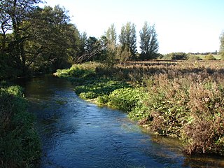
The River Nar is a river in England, a tributary of the River Great Ouse. It rises at Mileham near Litcham in Norfolk and flows 15 miles west through Castle Acre and Narborough, joining the Ouse at King's Lynn. It has had a variety of alternative names, such as the Setch, the Sandringham, and Lynn Flu, though these are rarely, if ever, used today. In 2011 the Nar was recognised by the Environment Agency as one of the top ten most improved rivers in England and Wales.

Sir Cornelius Vermuyden was a Dutch engineer who introduced Dutch land reclamation methods to England.

<span class="mw-page-title-main">Hatfield Chase</span> Human settlement in England

Hatfield Chase is a low-lying area in South Yorkshire and North Lincolnshire, England, which was often flooded. It was a royal hunting ground until Charles I appointed the Dutch engineer Cornelius Vermuyden to drain it in 1626. The work involved the re-routing of the Rivers Don, Idle, and Torne, and the construction of drainage channels. It was not wholly successful, but changed the whole nature of a wide swathe of land including the Isle of Axholme, and caused legal disputes for the rest of the century. The civil engineer John Smeaton looked at the problem of wintertime flooding in the 1760s, and some remedial work was carried out.

<span class="mw-page-title-main">Burnt Fen</span> Human settlement in England

Burnt Fen is an area of low-lying land crossed by the A1101 road between Littleport in Cambridgeshire and Mildenhall in Suffolk, England. It is surrounded on three sides by rivers, and consists of prime agricultural land, with sparse settlement. It is dependent on pumped drainage to prevent it from flooding.

<span class="mw-page-title-main">Forty Foot Drain</span>

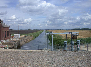
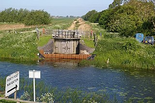
The Forty Foot or Forty Foot Drain is a name given to several of the principal channels in the drainage schemes of the Fens of Eastern England, the name being qualified when there is a need to distinguish between them. They are Vermuyden's Drain, South Forty Foot and North Forty Foot.

<span class="mw-page-title-main">Middle Level Navigations</span> Waterway network in eastern England

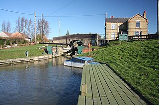
The Middle Level Navigations are a network of waterways in England, primarily used for land drainage, which lie in The Fens between the Rivers Nene and Great Ouse, and between the cities of Peterborough and Cambridge. Most of the area through which they run is at or below sea level, and attempts to protect it from inundation have been carried out since 1480. The Middle Level was given its name by the Dutch Engineer Cornelius Vermuyden in 1642, who subsequently constructed several drainage channels to make the area suitable for agriculture. Water levels were always managed to allow navigation, and Commissioners were established in 1754 to maintain the waterways and collect tolls from commercial traffic.

<span class="mw-page-title-main">Fens Waterways Link</span> Waterways project in eastern England

The Fens Waterways Link is a project to improve recreational boating opportunities in the counties of Cambridgeshire and Lincolnshire, England. By a combination of improvements to existing waterways and the construction of new links a circular route between Lincoln, Peterborough, Ely and Boston is planned. The project is being organised by the Environment Agency and financed from the Regional Development Agency and the European Union.

<span class="mw-page-title-main">Middle Level Commissioners</span>

The Middle Level Commissioners are a land drainage authority in eastern England. The body was formed in 1862, undertaking the main water level management function within the Middle Level following the breakup of the former Bedford Level Corporation.

<span class="mw-page-title-main">Downham West</span> Human settlement in England

Downham West is a civil parish in the English county of Norfolk The parish is 47.6 miles (76.6 km) west of Norwich, 16.3 miles (26.2 km) south-south-west of King's Lynn and 96.2 miles (154.8 km) north of London. The nearest town is Downham Market which is 2.5 miles (4.0 km) north east of the parish. The nearest railway station is at Downham Market for the Fen Line which runs between King's Lynn and Cambridge. The nearest airport is Norwich International Airport. The parish of Downham West, in the 2001 census, has a population of 285, rising marginally to 286 at the Census 2011. For the purposes of local government, the parish falls within the district of King's Lynn and West Norfolk.

<span class="mw-page-title-main">Welches Dam</span> Human settlement in England

Welches Dam is a hamlet and former civil parish, now in the parish of Manea, in the Fenland district, in the county of Cambridgeshire, England. It is around 5 miles (8 km) to the north west of Ely. The parish covered an area of 2,355 acres (953 ha). Within the parish boundaries were the hamlet of the same name and the settlement of Purls Bridge. In 1951 the parish had a population of 69. Welches Dam is the site of the visitor centre for the RSPB Ouse Washes reserve.

<span class="mw-page-title-main">Deeping Fen</span> Human settlement in England

Deeping Fen is a low-lying area in the South Holland district of Lincolnshire, England, which covers approximately 47 square miles (120 km2). It is bounded by the River Welland and the River Glen, and is extensively drained, but the efficient drainage of the land exercised the minds of several of the great civil engineers of the 17th and 18th centuries.

Adventurers were groups of English engineers and wealthy landowners, who funded large-scale land drainage projects in the seventeenth century, in return for rights to some of the land reclaimed.

<span class="mw-page-title-main">Cut-off Channel</span> River in England

The Cut-off Channel is a man-made waterway which runs along the eastern edge of the Fens in Norfolk and Suffolk, England. It was constructed in the 1950s and 1960s as part of flood defence measures, and carries the headwaters of the River Wissey, River Lark and River Little Ouse in times of flood, delivering them to Denver Sluice on the River Great Ouse. In the summer months, it is also used as part of a water supply scheme for drinking water in Essex.

References

  1. 1 2 "The Company of Adventurers and The Bedford Level Corporation" . Retrieved 10 January 2018.
  2. Corporation, Bedford Level. A Collection of Laws which Form the Constitution of the Bedford Level. p. 26.
  3. 1 2 Wells, Samuel. History of the Drainage of the Great Level of the Fens Called ..., Volume 1. p. 455.