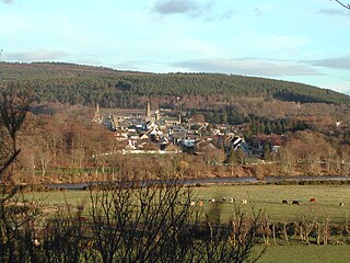
Fochabers is a village in the Parish of Bellie, in Moray, Scotland, 10 miles (16 km) east of the cathedral city of Elgin and located on the east bank of the River Spey. 1,728 people live in the village, which enjoys a rich musical and cultural history. The village is also home to Baxters, the family-run manufacturer of foodstuffs.
The Stonehenge Cursus is a large Neolithic cursus monument on Salisbury plain, near to Stonehenge in Wiltshire, England. It is roughly 3 kilometres (1.9 mi) long and between 100 metres (330 ft) and 150 metres (490 ft) wide. Excavations in 2007 dated the construction of the earthwork to between 3630 and 3375 BCE, several hundred years before the earliest phase of Stonehenge in 3000 BC. The cursus, along with adjacent barrows and the nearby 'Lesser Cursus' are part of the National Trust's Stonehenge Landscape property, and is within the Stonehenge and Avebury World Heritage Site.
Pennocrucium was a Romano-British settlement and military complex located at present day Water Eaton, just south of Penkridge, Staffordshire, with evidence of occupation from the mid-1st century until the 4th century.

Cawdor (Roman Fort), located near the small village of Easter Galcantray (15 miles or 24 kilometres east of Inverness), is suspected of being one of the northernmost Roman forts in Great Britain, though this is controversial.
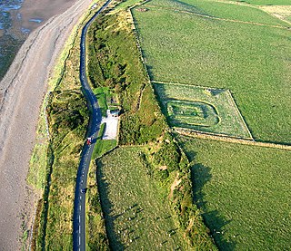
Milefortlet 21 (Swarthy Hill) was a Milefortlet of the Roman Cumbrian Coast defences. These defences were contemporary with defensive structures on Hadrian's Wall. Its remains exist as reconstructed turf ramparts (to a height of about 1 metre (3.3 ft)) and ditch, reinstated to its original profile (also around 1 metre (3.3 ft)). They are located on a low cliff on the coast, north of the village of Crosscanonby, and just inland from the coastal road. It is the only milefortlet to have been fully excavated and is open to the public.
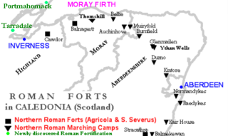
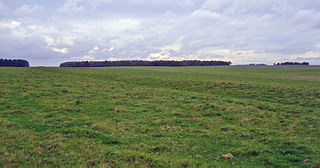
Muiryfold was one of the Roman fortifications built by Septimius Severus in northern Caledonia. The site is located 6 kilometres (3.7 mi) east of Keith in Moray.

Knowlton Circles are a complex of henges and earthworks in Knowlton, Dorset, England. The henge enclosing Knowlton Church is the best known and best preserved, but there are at least two other henges in the vicinity as well as numerous round barrows.

Milefortlet 11 was a Milefortlet of the Roman Cumbrian Coast defences. These milefortlets and intervening stone watchtowers extended from the western end of Hadrian's Wall, along the Cumbrian coast and were linked by a wooden palisade. They were contemporary with defensive structures on Hadrian's Wall. Milefortlet 11 has never been accurately located on the ground although other Roman remains have been found in the area.
Thomshill, located 6 kilometres (3.7 mi) south of Elgin in Moray, Scotland, is the site of an excavated rectilinear enclosure that has been interpreted as a possible Roman military camp or fort. The enclosure covers an area of approximately 3.25 hectares and is situated at a height of 72 metres (236 ft) above ordnance datum.
Balnageith, located on the western edge of the suburbs of Forres in Moray, Scotland, is the site of an excavated linear cropmark with a rounded corner that has been interpreted as a possible Roman military camp or fort. The enclosure may originally have been of up to 2.4 hectares in size.
Durno or Logie Durno, located 6 miles (9.7 km) north west of Inverurie in Aberdeenshire, Scotland, is the site of a Roman marching camp, first discovered by aerial photography in July 1975 and excavated in 1976 and 1977.

The Knock of Alves is a small wooded hill that lies 3 miles (4.8 km) to the west of Elgin in Moray, Scotland, rising to 335 feet (102 m) above ordnance datum. Its summit is marked by York Tower, a 3-storey octagonal folly erected in 1827 to commemorate Prince Frederick, the Duke of York; and the Forteath Mausoleum, built in 1850 as the burial place of 7 members of the Forteath family of the nearby house of Newton.
Wilsford Henge is the site of a Neolithic henge, west of the village of Wilsford, Wiltshire in the United Kingdom. The site was discovered from cropmarks in aerial photographs. The monument lies within the Vale of Pewsey, a short distance south of the large henge known as Marden Henge.

Boharm is a rural parish in the Speyside area of north Scotland, midway between Aberlour and Fochabers, and north of Dufftown. It lies on minor roads to either side of the A95. The main settlements in the parish are Maggieknockater and Mulben.

Bellie Kirk is a Georgian church of neoclassical design in Fochabers, Scotland, built in 1798 for the 4th Duke of Gordon. It has been in continuous use as a place of worship within the Church of Scotland, and is designated as a Category A listed building.
Curriestanes cursus is a large neolithic ditched enclosure on the outskirts of Dumfries, in the parish of Troqueer, Dumfries and Galloway. It is visible only from aerial photography. It is, along with Pict's Knowe, one of two scheduled monuments in Troqueer parish.
Broadlea henge is a Neolithic or Bronze Age monument in the parish of Middlebie, Dumfries and Galloway. It is one of very few henge monuments in southern Scotland. The only other well preserved site is the considerably smaller Pict's Knowe near Dumfries. While Pict's Knowe is a single entrance, Class I henge, Broadlea has two entrances, making it a Class II henge. It measures 50m by 45m inside its ditch, which is as wide as 10m. The banks have been flattened over time but still rise in parts to around four feet high.
Brandon Camp is an archaeological site, about 1 mile south of Leintwardine, in Herefordshire. England. It is a hillfort of the Iron Age, which later became a Roman fort. The site is a scheduled monument.

Oakwood Roman Fort and Camp is a British archaeological site, a Roman fort and nearby Roman camp, about 3.5 miles (5.6 km) south-west of Selkirk in the Scottish Borders. The site is a scheduled monument.
