
A castle is a type of fortified structure built during the Middle Ages predominantly by the nobility or royalty and by military orders. Scholars debate the scope of the word castle, but usually consider it to be the private fortified residence of a lord or noble. This is distinct from a palace, which is not fortified; from a fortress, which was not always a residence for royalty or nobility; and from a fortified settlement, which was a public defence – though there are many similarities among these types of construction. Usage of the term has varied over time and has been applied to structures as diverse as hill forts and country houses. Over the approximately 900 years that castles were built, they took on a great many forms with many different features, although some, such as curtain walls, arrowslits, and portcullises, were commonplace.

Harlech Castle in Harlech, Gwynedd, Wales, is a Grade I-listed medieval fortification built onto a rocky knoll close to the Irish Sea. It was built by Edward I during his invasion of Wales between 1282 and 1289 at the relatively modest cost of £8,190. Over the next few centuries, the castle played an important part in several wars, withstanding the siege of Madog ap Llywelyn between 1294–95, but falling to Owain Glyndŵr in 1404. It then became Glyndŵr's residence and military headquarters for the remainder of the uprising until being recaptured by English forces in 1409. During the 15th century Wars of the Roses, Harlech was held by the Lancastrians for seven years, before Yorkist troops forced its surrender in 1468, a siege memorialised in the song Men of Harlech. Following the outbreak of the English Civil War in 1642, the castle was held by forces loyal to Charles I, holding out until 1647 when it became the last fortification to surrender to the Parliamentary armies. In the 21st century the ruined castle is managed by Cadw, the Welsh Government's historic environment service, as a tourist attraction.

White Castle, also known historically as Llantilio Castle, is a ruined castle near the village of Llantilio Crossenny in Monmouthshire, Wales. The fortification was established by the Normans in the wake of the invasion of England in 1066, to protect the route from Wales to Hereford. Possibly commissioned by William fitz Osbern, the Earl of Hereford, it comprised three large earthworks with timber defences. In 1135, a major Welsh revolt took place and in response King Stephen brought together White Castle and its sister fortifications of Grosmont and Skenfrith to form a lordship known as the "Three Castles", which continued to play a role in defending the region from Welsh attack for several centuries.
The history of Northamptonshire spans the same period as English history.

Sandal Castle is a ruined medieval castle in Sandal Magna, a suburb of the city of Wakefield in West Yorkshire, England, overlooking the River Calder. It was the site of royal intrigue and the setting for a scene in one of William Shakespeare's plays.

Restormel Castle lies by the River Fowey near Lostwithiel in Cornwall, England, UK. It is one of the four chief Norman castles of Cornwall, the others being Launceston, Tintagel and Trematon. The castle is notable for its perfectly circular design. Although once a luxurious residence of the Earl of Cornwall, the castle was all but ruined by the 16th century. It was briefly reoccupied and fought over during the English Civil War but was subsequently abandoned. It is now under the supervision of the English Heritage and open to the public.
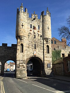
A gatehouse is a type of fortified gateway, an entry control point building, enclosing or accompanying a gateway for a town, religious house, castle, manor house, or other fortification building of importance. Gatehouses are typically the most heavily armed section of a fortification, to compensate for being structurally the weakest and the most probable attack point by an enemy. There are numerous surviving examples in France, Austria, Germany, England and Japan.

Cooling Castle is a 14th-century quadrangular castle in the village of Cooling, Kent on the Hoo Peninsula about 6 miles (9.7 km) north of Rochester. It was built in the 1380s by the Cobham family, the local lords of the manor, to guard the area against French raids into the Thames Estuary. The castle has an unusual layout, comprising two walled wards of unequal size next to each other, surrounded by moats and ditches. It was the earliest English castle designed for the use of gunpowder weapons by its defenders.

Benefield is a civil parish in North Northamptonshire, England, along the A427 road and about 6 miles (9.7 km) east of Corby and 3 miles (4.8 km) west of Oundle.

Pevensey Castle is a medieval castle and former Roman Saxon Shore fort at Pevensey in the English county of East Sussex. The site is a Scheduled Monument in the care of English Heritage and is open to visitors. Built around 290 AD and known to the Romans as Anderitum, the fort appears to have been the base for a fleet called the Classis Anderidaensis. The reasons for its construction are unclear; long thought to have been part of a Roman defensive system to guard the British and Gallic coasts against Saxon pirates, it has more recently been suggested that Anderitum and the other Saxon Shore forts were built by a usurper in an ultimately unsuccessful attempt to prevent Rome from reimposing its control over Britain.

Wadenhoe is a village and civil parish in North Northamptonshire. The population of the civil parish at the 2011 Census was 244. It is on the River Nene, approximately 4 miles from Thrapston and 10 miles from Corby. The Nene Way long-distance footpath passes through the village.
Buckton Castle was a medieval enclosure castle near Carrbrook in Stalybridge, Greater Manchester, England. It was surrounded by a 2.8-metre-wide (9 ft) stone curtain wall and a ditch 10 metres (33 ft) wide by 6 metres (20 ft) deep. Buckton is one of the earliest stone castles in North West England and only survives as buried remains overgrown with heather and peat. It was most likely built and demolished in the 12th century. The earliest surviving record of the site dates from 1360, by which time it was lying derelict. The few finds retrieved during archaeological investigations indicate that Buckton Castle may not have been completed.

Llanblethian is a village in the Vale of Glamorgan in Wales which sits upon the River Thaw. It makes up part of the community of Cowbridge with Llanblethian, which consists of the village itself, the larger market town of Cowbridge and Aberthin.

The Castles and Town Walls of King Edward in Gwynedd is a UNESCO-designated World Heritage Site located in Gwynedd, Wales. It includes the castles of Beaumaris and Harlech and the castles and town walls of Caernarfon and Conwy. UNESCO considers the sites to be the "finest examples of late 13th century and early 14th century military architecture in Europe".
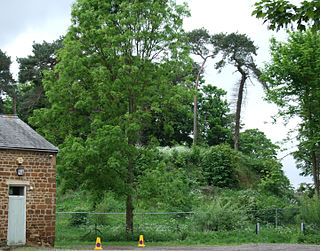
Bury Mount Motte is the remains of an earthwork motte and bailey fortification or ancient castle, and has been designated a Scheduled Ancient Monument. The Motte probably dates back to the 11th Century when it was a Norman fortification but over time was subject to neglect.

While there are many castles in South Yorkshire, the majority are manor houses and motte-and-bailey which were commonly found in England after the Norman Conquest.

Rochester Castle stands on the east bank of the River Medway in Rochester, Kent, South East England. The 12th-century keep or stone tower, which is the castle's most prominent feature, is one of the best preserved in England or France.

Fotheringhay Castle, also known as Fotheringay Castle, was a High Middle Age Norman Motte-and-bailey castle in the village of Fotheringhay 3+1⁄2 miles (5.6 km) to the north of the market town of Oundle, Northamptonshire, England. It was probably founded around 1100 by Simon de Senlis, Earl of Northampton. In 1113, possession passed to Prince David of Scotland when he married Simon's widow. The castle then descended with the Scottish princes until the early 13th century, when it was confiscated by King John of England.

Whorlton Castle is a ruined medieval castle situated near the abandoned village of Whorlton in North Yorkshire, England. It was established in the early 12th century as a Norman motte-and-bailey associated with the nearby settlement. The castle is an unusual example of a motte-and-bailey that remained in use throughout the Middle Ages and into the early modern period.
