Beverly Hills Post Office

Last updated

The old Beverly Hills Main Post Office, 469 N. Crescent Dr. at Santa Monica Boulevard in Beverly Hills, served Beverly Hills and the BHPO area of Los Angeles from 1934 to the 1990s. BeverlyHillsPostOffice03.jpg
The old Beverly Hills Main Post Office, 469 N. Crescent Dr. at Santa Monica Boulevard in Beverly Hills, served Beverly Hills and the BHPO area of Los Angeles from 1934 to the 1990s.
Warner Avenue School Warner Elem School.jpg
Warner Avenue School
Emerson Middle School Emerson Middle School.jpg
Emerson Middle School
University High School UniversityHSLosAngeles.jpg
University High School

Beverly Hills Post Office (BHPO) is the name given to a section of Los Angeles, California, that lies within the 90210 ZIP code, assigned to the Beverly Hills Post Office. Los Angeles mailing addresses with the ZIP code 90210 may be written as "Beverly Hills, CA 90210", though the properties themselves lie outside of the Beverly Hills city limits.

Contents

Description

Beverly Hills Post Office (BHPO) is a neighborhood in Los Angeles, California, that is adjacent to the city of Beverly Hills. Because the United States Postal Service in Beverly Hills serves the neighborhood, residents have a Beverly Hills mailing address with zip code 90210, while other wealthy neighborhoods Bel Air and Holmby Hills have Los Angeles mailing addresses. While the Beverly Hills connection makes BHPO—about one-third the size of the city—attractive, land is available in larger sizes, and with lower prices, better views, and more seclusion, than in Beverly Hills itself. [1]

The BHPO area itself contains a number of neighborhoods, including Benedict Canyon and Coldwater Canyon. [2] [1]

History

The Los Angeles Times wrote in 2004, "When Beverly Hills was incorporated in 1914, the northern border was roughly one mile (1.6 km) north of Sunset Boulevard, with the exception of Trousdale Estates. The remaining section stretching north to Mulholland Drive was left as part of the hills of Los Angeles, where it remained anonymous for decades". [3] In the 1920s, the federal government decided to have the Beverly Hills post office serve the area now known as BHPO, which was then a rural area, much of it part of Doheny Ranch. By the 1940s people bought BHPO homes because they were less expensive than in Beverly Hills, despite higher property taxes. [1] In 1963, the area was included within the 90210 ZIP Code, which also covers the northern part of Beverly Hills. [3] Property taxes were higher in Los Angeles than in Beverly Hills until 1978 California Proposition 13 equalized property taxes, making BHPO more attractive. [1]

Post Office

The ZIP Code 90210 is still handled by the Beverly Hills Main Post Office. The original Beverly Hills Main Post Office from 1934 to the 1990s still sits at 469 North Crescent Drive in the Beverly Hills Civic Center, and was added to the National Register of Historic Places in 1985. [4] [5] In 1990, 325 North Maple Street was rebuilt as the new Beverly Hills Main Post Office; the old Main on Crescent Drive was closed in 1999 when the building was sold back to the City of Beverly Hills. [4] [5] Beverly Hills has other Post Offices in other ZIP Codes as well.

City services

BHPO residents do not have access to Beverly Hills Police Department, Beverly Hills Fire Department or any Beverly Hills city services. [1] As citizens of the city of Los Angeles, they receive Los Angeles city services and vote in Los Angeles elections. This can cause problems with emergency response. For example, when actress Demi Moore needed an ambulance in January 2012, Beverly Hills and Los Angeles 9-1-1 operators used over two minutes to determine jurisdiction for her home. [6]

Education

Public education is provided by the Los Angeles Unified School District [3] as opposed to the Beverly Hills Unified School District, which serves students within Beverly Hills city limits. [1]

The western part of the Beverly Hills Post Office area is zoned to Warner Avenue Elementary School, while the eastern portion is zoned to West Hollywood Elementary School.

All residents are zoned to Emerson Middle School and University High School.

Related Research Articles

<span class="mw-page-title-main">Beverly Hills, California</span> Urban City in California, United States

Beverly Hills is a city located in Los Angeles County, California, United States. A notable and historic suburb of Los Angeles, it is located immediately southwest of the Hollywood Hills, approximately 12.2 miles (19.6 km) northwest of downtown Los Angeles. Beverly Hills' land area totals to 5.71 square miles (14.8 km2), and is entirely surrounded by the city of Los Angeles. According to the 2020 census, the city has a population of 32,701; marking a decrease of 1,408 from the 2010 census count of 34,109.

<span class="mw-page-title-main">Mission Hills, Los Angeles</span> Neighborhood of Los Angeles in California, United States

Mission Hills is a suburban neighborhood in the City of Los Angeles, California, located in the San Fernando Valley.

<span class="mw-page-title-main">Pacific Palisades, Los Angeles</span> Neighborhood in Los Angeles, California, United States

Pacific Palisades is a neighborhood in the Westside region of Los Angeles, California, situated about 20 miles (32 km) west of Downtown Los Angeles.

<span class="mw-page-title-main">West Hills, Los Angeles</span> Neighborhood in Los Angeles, California, United States

West Hills is a suburban / residential community in the western San Fernando Valley region of the City of Los Angeles, California. The percentage of residents aged 35 and older is among the highest in Los Angeles County.

90210 may refer to

Benedict Canyon is an area in the Westside of the city of Los Angeles, California.

<span class="mw-page-title-main">Doheny Drive</span> North-south thoroughfare in Los Angeles County, California

Doheny Drive is a north–south thoroughfare mostly through Beverly Hills and West Hollywood, in Los Angeles County, California.

Beverly Glen is a neighborhood in the Santa Monica Mountains region of Los Angeles, California, located around Beverly Glen Boulevard north of Sunset Boulevard and south of Mulholland Drive. Stone Canyon Reservoir lies in the neighborhood.

<span class="mw-page-title-main">Beverly Park, Los Angeles</span> Neighborhoods of Los Angeles, California, United States of America

Beverly Park, divided into North Beverly Park and South Beverly Park, is a gated community in Los Angeles, California primarily known for its large houses and famous residents. It is between Mulholland Drive and Sunset Boulevard and Coldwater Canyon Drive and Beverly Glen Boulevard, east of the Beverly Glen neighborhood.

<span class="mw-page-title-main">Beverly Drive</span>

Beverly Drive is a major north–south roadway in Beverly Hills and Los Angeles.

Beverly Crest is a neighborhood in the Santa Monica Mountains, in the Westside area of the city of Los Angeles, California.

<span class="mw-page-title-main">Emerson Community Charter School</span> Public secondary school

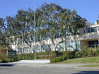
Ralph Waldo Emerson Community Charter School is a charter middle school in the Los Angeles Unified School District in Westwood, Los Angeles, California, United States. It was designed by famed architect Richard Neutra and was named in honor of Ralph Waldo Emerson, the American author, poet, and philosopher.

<span class="mw-page-title-main">Hollywood Hills West, Los Angeles</span>

Hollywood Hills West is a neighborhood within Central Los Angeles, California.

<span class="mw-page-title-main">Beverly Hills City Hall</span> City hall in Beverly Hills, California

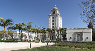
The Beverly Hills City Hall is a historic building and city hall in Beverly Hills, California, United States.

<span class="mw-page-title-main">Beverly Hills Main Post Office</span>

The old Beverly Hills Main Post Office is a Renaissance Revival building at the Beverly Hills Civic Center in Beverly Hills, California. The building has carried the addresses 469 North Crescent Drive and 470 North Canon Drive. It was built as the main post office in the 1930s, remaining a post office until the 1990s, and in the 2010s became the Paula Kent Meehan Historic Building of the Wallis Annenberg Center for the Performing Arts.

<span class="mw-page-title-main">Coldwater Canyon Avenue</span>

Coldwater Canyon Avenue is a street, primarily within the City of Los Angeles, in Los Angeles County, California. It runs 10.3 miles (16.6 km) from North Beverly Drive at Coldwater Canyon Park in Beverly Hills, north up Coldwater Canyon, including a short stretch shared with Mulholland Drive, ending at a crossroad intersection with Roscoe Boulevard in Sun Valley, where the Coldwater Canyon Avenue changes into Sheldon Street.

<span class="mw-page-title-main">Mulholland Estates</span> Guard gated community located in the Santa Monica Mountains

Mulholland Estates is a guard gated community in the Santa Monica Mountains of Southern California, US. Although properties in the estate have a 90210 ZIP code and thus a Beverly Hills address, it is actually part of the Beverly Hills Post Office area in the city of Los Angeles, with much of the land located inside the Sherman Oaks district. The community's main entrance is located at Beverly Glen Boulevard and Mulholland Drive, next to Fossil Ridge Park, and it looks out to the San Fernando Valley.

Le Palais also known as "The Crescent Palace," is a three-story French chateau-style limestone mega-mansion completed in 2012 by luxury real estate developer Mohamed Hadid just 15 months after breaking ground. It is the 4th largest private residence by square footage in the Greater Los Angeles Metropolitan Area.

References

  1. 1 2 3 4 5 6 Ryon, Ruth; Smith, Jack (October 8, 1989). "The Post Office Area: Almost Beverly Hills, for a Lot Less Money". Los Angeles Times. Retrieved May 11, 2020.
  2. Historic Resources Survey Report: Bel Air – Beverly Crest Community Plan Area, SurveyLA, November 2013.
  3. 1 2 3 Spitz, H. May. Canyon homes and that famous ZIP code." Los Angeles Times , 11 July 2004.
  4. 1 2 "1932 Crescent Drive Post Office Historic Structure Report". Los Angeles: Hardy Holzman Pfeiffer Associates. July 2002. Retrieved June 18, 2015.
  5. 1 2 Ostashay, Jan (October 3, 2012). "Re: LANDMARK ASSESSMENT CONFIRMATION REVIEW: U.S. Post Office, Beverly Hills Main Post Office, 469 North Crescent Drive (470 North Canon Drive), Beverly Hills, CA" (PDF). Long Beach, California. Retrieved June 17, 2015. Includes National Register of Historic Places Inventory - Nomination Form as attachment.
  6. "Dispatchers Taking Demi Moore's 911 Call Confused Over Who Should Respond". CBS Los Angeles News. January 27, 2012. Retrieved January 30, 2012.

34°4′20.9″N118°24′6.65″W / 34.072472°N 118.4018472°W / 34.072472; -118.4018472