Bhagamandala

Last updated

Bhagamandala
Village
Bhagmandala2.JPG
Bhagandeshwara Temple
India Karnataka location map.svg
Red pog.svg
Bhagamandala
Location in Karnataka, India
India location map.svg
Red pog.svg
Bhagamandala
Bhagamandala (India)
Coordinates: 12°25′11″N75°31′19″E / 12.4196500°N 75.5218300°E / 12.4196500; 75.5218300
CountryFlag of India.svg  India
State Karnataka
District Kodagu
Taluk Madikeri
Government
  Body Grama Panchayath
Area
  Total32.51 km2 (12.55 sq mi)
Elevation
898 m (2,946 ft)
Population
 (2011)
  Total1,917 [1]
Languages
  Official Kannada
  Other Arebhashe, Kodava, Malayalam
Time zone UTC+5:30 (IST)
PIN
571 247
Telephone code08272
Vehicle registration KA-12

Bhagamandala is a pilgrimage place in Kodagu district of the Indian state of Karnataka.

Contents

Kaveri in Bhagamandala Kaveri in Bhagamandala.jpg
Kaveri in Bhagamandala
View of Thavooru Gudde (Mt. Thavooru) and Hotel Mayura Kauvery from the winding road above Bhagmandala1.jpg
View of Thavooru Gudde (Mt. Thavooru) and Hotel Mayura Kauvery from the winding road above

Location

Bhagamandala is situated on the river Kaveri in its upstream stretches. At this place, the Kaveri is joined by two tributaries, the Kannike and the mythical Sujyothi river. It is considered sacred as a river confluence (kudala or triveni sangama , in Kannada and Sanskrit respectively). Bhagamandala is located 133 km south-east of Mangalore. It has an average elevation of 898 m (2,946 ft). [2]

Pilgrim center – Bhagandeshwara Temple

It is a common practice for pilgrims to take a dip in the triveni sangama and perform rituals to their ancestors before proceeding to Talakaveri, the birthplace of Kaveri. A temple of Lord Supremo Shiva in the name of Bhagandeshwara embellishes the place. It is the local belief that Kaveri, revered as Dakshina Ganga, comes out of the matted hair locks of Shiva here. During Tula Sankramana which falls on 17 or 18 October, pilgrims assemble here in large numbers.

Three river meet

A short distance from the triveni sangama, there is a famous temple known as Sri Bhagandeshwara Temple, where murti (sacred images) of Bhagandeshwara (Ishwara), Subramanya and Ganapati are installed. This place is also known as Bhagandeshwara Kshetra, from which the name Bhagamandala is derived. The temples in this area are built in Karavali (West Coast) style.

History

During 1785–1790, the area was occupied by Tipu Sultan. The temple was burnt and destroyed. [3] He renamed Bhagamandala to Afzalabad. [4] [5] In 1790 King Dodda Vira Rajendra took Bhagamandala back into an independent Kodagu kingdom.

Bhagamandala is located about 33 km from the district headquarters Madikeri and is connected by paved roads from Madikeri, Virajpet and nearby places in Karnataka and Kerala. Government and private buses are available on all of these routes.

Padi temple

A short distance from Bhagamandala is the temple at Padi, which houses the deity Lord Igguthappa and is one of the most sacred shrines of the Kodava people. [6] [7] [8]

Aiyangeri temple

There is one more temple at Aiyangeri, named "Chinnathappa", which houses the deity Lord Sri Krishna, considered by the people of the village to be the most sacred shrine in their home land. There is a festival once a year in the month of February or March, where the "Golden Flute" will be brought out from the temple.

Mount Thavoor

Bhagamandala temple Bhagyamandala Temple.JPG
Bhagamandala temple

Mt. Thavoor is a peak overlooking Bhagamandala and Mt. Koppatti (elevation 1,475 metres (4,839 ft); 12°24′17.6688″N75°35′40.2936″E / 12.404908000°N 75.594526000°E / 12.404908000; 75.594526000 ), which may be considered its twin peak is nearby and both these serve as trekking routes for the Shola forest range.

Kashi Math

Bhagmandala Shri Kashi Math is a branch of Shri Kashi Math Samsthan, Varansi located in Bhagmandala.

Climate

Bhagamandala experiences a Tropical monsoon climate under the Köppen climate classification.

Climate data for Bhagamandala
MonthJanFebMarAprMayJunJulAugSepOctNovDecYear
Average high °C (°F)26.5
(79.7)
28.1
(82.6)
29.6
(85.3)
29.2
(84.6)
27.9
(82.2)
23.9
(75.0)
22.4
(72.3)
22.8
(73.0)
23.9
(75.0)
25.5
(77.9)
25.6
(78.1)
25.8
(78.4)
25.9
(78.7)
Average low °C (°F)16.0
(60.8)
17.0
(62.6)
18.5
(65.3)
19.7
(67.5)
20.0
(68.0)
18.9
(66.0)
18.6
(65.5)
18.6
(65.5)
18.4
(65.1)
18.6
(65.5)
17.8
(64.0)
16.4
(61.5)
18.2
(64.8)
Average rainfall mm (inches)5
(0.2)
5
(0.2)
20
(0.8)
115
(4.5)
232
(9.1)
1,222
(48.1)
2,024
(79.7)
1,222
(48.1)
479
(18.9)
318
(12.5)
101
(4.0)
24
(0.9)
5,767
(227)
Source 1: Directorate of Economics and Statistics, Karnataka [9]
Source 2: Climate-Data.org [10]

Rainfall

Bhagamandala is the highest rainfall receiving station in the Kodagu district, every year. In 2018, it received an annual rainfall of 5,585 millimetres (219.9 in). [11]

In 2019, Bhagamandala received 4,687 millimetres (184.5 in) of annual rainfall, this time falling behind Hudikeri, which received 4,716 millimetres (185.7 in) of rainfall. [12]

In 2022, it received a total of 5,163 millimetres (203.3 in) rainfall, making it the 4th highest rainfall receiving station in Karnataka, after Kundapura (5806mm), Ajekar (5730mm) and Byndoor (5284mm). [13]

See also

Related Research Articles

<span class="mw-page-title-main">Kodagu district</span> District of Karnataka in India

Kodagu district is an administrative district in the Karnataka state of India. Before 1956, it was an administratively separate Coorg State, at which point it was merged into an enlarged Mysore State.

<span class="mw-page-title-main">Madikeri</span> City in Karnataka, India

Madikeri is a hill station town in Madikeri taluk and headquarters of Kodagu district in Karnataka, India.

<span class="mw-page-title-main">Talakaveri</span> Birth place of River Kaveri

Talakaveri or Talacauvery is the place that is generally considered to be the source of the river Kaveri and a holy place for many Hindus. It is located on Brahmagiri hills near Bhagamandala in Kodagu district, Karnataka State. It is located close to the border with Kasaragod district. Talakaveri stands at a height of 1,276 meters above sea level. However, there is not a permanent visible flow from this place to the main rivercourse except during the Monsoon.

<span class="mw-page-title-main">Malenadu</span> Region in Karnataka, India

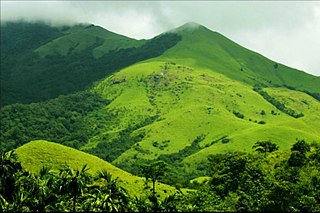
Malnad is a region in the state of Karnataka in India. Malenadu covers the western and eastern slopes of the Western Ghats or Sahyadri mountain range, and is roughly 100 kilometers in width. The region experiences heavy annual rainfall of 1000 to 3800 mm; it includes Agumbe, which receives the highest annual rainfall in Karnataka.

<span class="mw-page-title-main">Kodava people</span> Ethnic group in India

The Kodava people or Kodavas or Codavas are an ethno-linguistic group from the region of Kodagu in the southern Indian state of Karnataka, who natively speak the Kodava language. They are traditionally land-owning agriculturists and patrilineal, with martial customs. Kodavas worship ancestors and weapons. They used to worship swords, bows, arrows and later guns. Hence, Kodavas are the only ones in India permitted to carry firearms without a license.

The town of Virajpet also spelled as Virajapete is the second town of the district of Kodagu (Coorg), in Karnataka. It is the main town of the Virajpet taluka, south of the district, in the Kerala-Karnataka border. The name is an abbreviation of Virarajendrapete after the former ruler of Kodagu, Virarajendra.

<span class="mw-page-title-main">Somwarpet</span> Town in Karnataka, India

Somwarpet is a panchayat town in Coorg district in the Indian state of Karnataka. It is the main town of the Somwarpet taluk, in the north-east of the district. 2nd highest Administrative town in Karnataka in terms of elevation. The main crops grown in the area are coffee and spice crops such as cardamom, peppers, oranges, ginger and vegetables.

<span class="mw-page-title-main">Kushalanagar</span> Town in Karnataka, India


Kushalanagar or Kushalanagara is a city located in the Kodagu district of the Indian state of Karnataka. Surrounded by Kaveri river, it is the gateway to Kodagu district. It also serves as the headquarters of Kushalanagar Taluk. By population, Kushalanagar is the second largest town in Kodagu district after Madikeri and the fastest developing town in the district. Kushalnagar is an important commercial centre in Kodagu.

<span class="mw-page-title-main">Gonikoppal</span> Town in Karnataka, India

Gonikoppal is a census town in the Kodagu district of the Indian state of Karnataka.

<span class="mw-page-title-main">Triveni Sangam</span> Junction of three rivers in India

In Hindu tradition, Triveni Sangam is the confluence of three rivers that is also a sacred place, with a bath here said to flush away all of one's sins and free one from the cycle of rebirth.

<span class="mw-page-title-main">Pushpagiri (mountain)</span>

Pushpagiri, at 5,626 feet (1,715 m) ft, is the highest peak in Pushpagiri Wildlife Sanctuary in the Western Ghats of Karnataka. It is located in the Somwarpet Taluk, 20 kilometres (12 mi) from Somwarpet in the northern part of Kodagu district on the border between Dakshina Kannada and Kodagu district and hassan districts. It is 4th highest peak of Karnataka.

<span class="mw-page-title-main">Irupu Falls</span> Waterfall in Karnataka, India

The Irupu Falls are located in the Brahmagiri Range in the Kodagu district of Karnataka, India, bordering the Wayanad district of Kerala. It is a fresh water cascade and is situated at a distance of 48 km from Virajpet on the highway to Nagarhole. The Falls are also known as the Lakshmana Tirtha Falls, derived from the name of the tributary of Cauvery which starts from these falls, the Lakshmana Tirtha River.

<span class="mw-page-title-main">Honnamana Kere</span> Town in Karnataka, India

Honnamana Kere is a lake and holy place in Doddamalthe near the village of Sulimalthe, 6 km away from Somwarpet town of Coorg in the state of Karnataka, India. It is the biggest lake in Kodagu, and once a year, during the Gowri festival, a special pooja is conducted and a 'Bagina' which consists of the belongings of goddess Honamma is presented to the lake.

Appachcha Kavi was an Indian poet and playwright. He belonged to the Kodava community. He is known as the first playwright in the Kodava language.

<span class="mw-page-title-main">Siddapura, Kodagu</span> Place in Karnataka, India

Siddapur or Siddapura is a village in Kodagu district, Karnataka, in India. It is situated in a coffee growing region near the river Kaveri.

<span class="mw-page-title-main">Appayya Swamigalu</span> Indian hindu monk

Appaiah Swami or Sadguru Appayya Swami was a Hindu Indian spiritual master who lived in Virajpet town, in Kodagu, Karnataka, India.

<span class="mw-page-title-main">Igguthappa</span>

Igguthappa is a Kodava deity worshipped in Kodagu, India.

<span class="mw-page-title-main">Chettalli</span> Place in Karnataka, India

Chettalli is a small village near Siddapura, Kodagu in Karnataka state, India.

Coorg was a constituency of the Lok Sabha. It was used in the parliamentary election of 1951–1952. The constituency elected a single member of the Lok Sabha and was the sole Lok Sabha seat for the Coorg State. As of 1952, the constituency had 94,593 eligible voters.

<span class="mw-page-title-main">Attur, Virajpet</span> Village in Karnataka, India

Atthur is a small village near Gonikoppa in Virajpet Taluk of Kodagu District, Karnataka State, India. It comes under Guhya Panchayath. It belongs to Mysore Division. It is located 37 km (23 mi) towards South from District headquarters Madikeri and 240 km (150 mi) from State capital Bangalore.

References

  1. "Kodagu Census Handbook 2011" (PDF). Retrieved 31 July 2023.
  2. "Elevation of Bhagamandala". Archived from the original on 21 May 2019. Retrieved 15 October 2017.
  3. Moegling, H (1855). Coorg Memoirs: An Account of Coorg and of the Coorg Mission. p. 98. Retrieved 11 February 2014.
  4. "Bhagandeshwara temple , where is it located ? | Tourism of karnataka". tourismofkarnataka.com. Retrieved 26 August 2021.
  5. "Karnataka Kodagu Gazetteer 1965" (PDF). Archived (PDF) from the original on 2 August 2021.
  6. Belliappa, C P (7 February 2012). "At the summit of faith". Deccan Herald. Retrieved 2 November 2014.
  7. Kushalappa, Mookonda. "PADI IGGUTHAPPA TEMPLE DEDICATED TO RAIN AND HARVEST GOD OF COORG". Coorg Tourism Info. P T Bopanna. Retrieved 2 April 2019.
  8. "Padi Sri Igguthappa Temple". Padi Sri Igguthappa Temple. Chinshai Technologies. Archived from the original on 2 November 2014. Retrieved 2 November 2014.
  9. "DES" (PDF). DES. Retrieved 7 July 2016.
  10. "CLIMATE: BHAGAMANDALA" . Retrieved 18 February 2016.
  11. "Annual State Report 2018" (PDF). Retrieved 14 August 2023.
  12. "Annual State Report 2019" (PDF). Retrieved 14 August 2023.
  13. "Annual State Report 2022" (PDF). Retrieved 21 June 2023.