
Barbury Castle is a scheduled hillfort in Wiltshire, England. It is one of several such forts found along the ancient Ridgeway route. The site, which lies within the Wessex Downs Area of Outstanding Natural Beauty, has been managed as a country park by Swindon Borough Council since 1971. It is situated on Barbury Hill, a local vantage point, which, under ideal weather conditions, commands a view across to the Cotswolds and the River Severn. It has two deep defensive ditches and ramparts. The Old Ridgeway runs close by and the modern Ridgeway crosses through the castle. In the surrounding area are to be found round barrows, Celtic field systems and 18th-19th century flint workings.
Whitsbury is a village and civil parish in Hampshire, England, close to Fordingbridge. Whitsbury is a part of a group of villages on the edge of the Cranborne Chase and West Wiltshire Downs Area of Outstanding Natural Beauty.

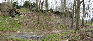
Blackbury Camp, also known as Blackbury Castle, is an Iron Age hill fort in Devon, England. It is managed by English Heritage.

Yarnbury Castle is the site of a multiphase, multivallate Iron Age hillfort near the village of Steeple Langford, Wiltshire, England. The site covers an area of 28.5 acres (11.5 ha), and was extensively surveyed and investigated by the Royal Commission on the Historical Monuments of England in 1991, with finds of Iron Age and Romano-British pottery, Iron Age and Roman coins, and burials of human remains. There is much evidence of prolonged and extensive settlement of the site, including evidence of around 130 structures of various sizes, most probably representing a mix of round houses, pits, and other features. It was designated as a scheduled monument in 1925.

Castle Neroche is a Norman motte-and-bailey castle on the site of an earlier hill fort in the parish of Curland, near Staple Fitzpaine, Somerset, England. It is a Scheduled Ancient Monument.
Vespasian's Camp is an Iron Age hillfort just west of the town of Amesbury, Wiltshire, England. The hillfort is less than 3 kilometres (2 mi) from the Neolithic and Bronze Age site of Stonehenge, and was built on a hill next to the Stonehenge Avenue; it has the River Avon on its southern side and the A303 road on its northern edge. The site is a scheduled monument and lies within the boundaries of the Stonehenge World Heritage Site.

Kenwalch's Castle is probably an Iron Age hill fort that may have been converted into a Roman fortress, near Penselwood, Somerset, England, 6.6 kilometres (4 mi) east south east of Bruton at grid reference ST747335. It is a Scheduled Ancient Monument. It is believed to be named after Cenwalh of Wessex.

The Trundle is an Iron Age hillfort on St Roche's Hill about 4 miles (6 km) north of Chichester, West Sussex, England, built on the site of a causewayed enclosure, a form of early Neolithic earthwork found in northwestern Europe. Causewayed enclosures were built in England from shortly before 3700 BC until at least 3500 BC; they are characterized by the full or partial enclosure of an area with ditches that are interrupted by gaps, or causeways. Their purpose is not known; they may have been settlements, meeting places, or ritual sites. Hillforts were built as early as 1000 BC, in the Late Bronze Age, and continued to be built through the Iron Age until shortly before the Roman occupation.

Scratchbury Camp is the site of an Iron Age univallate hillfort on Scratchbury Hill, overlooking the Wylye valley about 1 km northeast of the village of Norton Bavant in Wiltshire, England. The fort covers an area of 37 acres (15 ha) and occupies the summit of the hill on the edge of Salisbury Plain, with its four-sided shape largely following the natural contours of the hill.

Bury Camp is the site of an Iron Age multivallate hillfort in north-west Wiltshire, England. It occupies a triangular promontory of Colerne Down, in the north of Colerne parish, at the southern edge of the Cotswold Hills between two spurs of a river valley. The enclosed area of approximately 9.2ha is surrounded by a ditch 4m wide and up to 1m deep, and an outer rampart up to 1.5m high on the east and northwestern sides and up to 2m high on the southwestern side, across the neck of the promontory.

Castle Ditches is the site of an Iron Age trivallate hillfort in the south-east of Tisbury parish in Wiltshire, England.

Chiselbury is the site of an Iron Age univallate hillfort in Wiltshire, England. The hillfort is sub-circular in plan, and encloses an area of approximately 10.5 acres (460,000 sq ft). It is defined by an earthen rampart up to 3.6 metres (12 ft) in height and an external ditch, up to a maximum of 1.6 metres (5.2 ft) in depth. A gap in the south-eastern side of the rampart, and a corresponding causeway across the ditch, is thought to be the original entrance and is associated with a small 'D' shaped embanked enclosure, which is apparently visible on aerial photographs. Although the enclosure has subsequently been degraded by ploughing, it is still apparent as a series of low earthworks.
Chisenbury Camp is the site of an Iron Age univallate hillfort in Broad Chalke parish in Wiltshire, England. The site comprises a small circular 5-acre enclosure that was levelled in 1931. The site was partially excavated in the 19th century and there were finds of ceramics, worked stone, worked animal bone and remains of human burial; some are held by the Wiltshire Museum at Devizes. It is a scheduled monument.
Hillforts in Britain refers to the various hillforts within the island of Great Britain. Although the earliest such constructs fitting this description come from the Neolithic British Isles, with a few also dating to later Bronze Age Britain, British hillforts were primarily constructed during the British Iron Age. Some of these were apparently abandoned in the southern areas that were a part of Roman Britain, although at the same time, those areas of northern Britain that remained free from Roman occupation saw an increase in their construction. Some hillforts were reused in the Early Middle Ages, and in some rarer cases, into the Later Medieval period as well. By the early modern period, these had essentially all been abandoned, with many being excavated by archaeologists in the nineteenth century onward.
Membury Camp, or Membury Fort, is the site of an Iron Age hill fort located on the borders of Wiltshire and Berkshire,. The site encompasses 14 acres, and is situated in the south-western corner of a small plateau. The circular earthworks are completely shrouded in trees and inside the walls it is mostly arable farmland. To the northeast, in the Berkshire segment, the camp is totally wooded by a small copse, Walls Copse, which covers a quarter of the site. To the north and east the adjoining ground is flat, but to the south and west it falls away steeply, providing a natural defence. The camp consists of a single ditch with banks on either side and encloses and area measuring 390m by 490m. A gap in the east with inturning flanks is probably an original entrance though it is mutilated and overgrown. Other gaps in the banks appear to be more modern. A possible hut circle is visible as a cropmark situated at the south end of the hill fort. The east side of the earthwork has been partly destroyed by the construction of a wartime airfield, RAF Membury. The site has not been excavated but a number of prehistoric finds have been found in the vicinity. It is a scheduled ancient monument no. 228970 There have been several collections of pottery found, in 1977, 1980 and 1987 Other significant finds have also included for flint artefacts from the mesolithic era, and flint tools from the neolithic era, prior to the Iron Age.
Grovely Castle is the site of an Iron Age univallate hill fort in the parish of Steeple Langford, in Wiltshire, England. The remaining ramparts stand approximately 3.2 m (10 ft) high, with 1.5 m (4.9 ft) deep ditches, although ploughing has damaged the earthworks in some parts of the site. Excavations have uncovered the remains of five human skeletons within the ramparts. Entrances are in the south-west and north-east corners of the hillfort. A circular enclosure of 35 to 40 m is evident in aerial photographs of the hillfort interior. There is also a later bank and ditch which runs through the hill-fort from south-west to north-east, and is probably part of an extensive surrounding Celtic field system.

Knook Castle is the site of an Iron Age univallate hillfort on Knook Down, near the village of Knook in Wiltshire, England, but largely within the civil parish of Upton Lovell. It has also been interpreted as a defensive cattle enclosure associated with nearby Romano-British settlements. It is roughly rectangular in plan with a single entrance on the south/south-east side, but with a later break in the wall on the western side. The site is a scheduled monument.
Dudsbury Camp is one of a series of Iron Age earthworks in Dorset, starting from Hambledon Hill, and including Hod Hill, Spetisbury Rings, Buzbury Rings, Badbury Rings and Dudsbury Camp. The Iron Age port at Hengistbury Head forms a final Iron Age monument in this small chain of sites. The fort is located near the village of West Parley.

The Martin Down Enclosure is an archaeological site on Martin Down, near the village of Martin, in Hampshire, England. It is near the boundaries with Dorset and Wiltshire.

Thundersbarrow Hill is an archaeological site in West Sussex, England. It is on a chalk ridge, aligned north-west to south-east, on the South Downs north of Shoreham-by-Sea.


