Related Research Articles

Marche or the Marches is one of the twenty regions of Italy. The name of the region derives from the plural name of marca, originally referring to the medieval March of Ancona and nearby marches of Camerino and Fermo. Marche is well known for its shoemaking tradition, with the finest and most luxurious Italian footwear being manufactured in this region.

The Savio is a river in the Emilia-Romagna region of northern Italy. Its source is in the province of Forlì-Cesena near Montecoronaro on Mount Castelvecchio which is near the western side of Mount Fumaiolo. The source is at an elevation of 1,126 metres (3,694 ft) and is marked by an iron monument. A wolf and the rings of the "caveja" are on this monument. The river flows near Verghereto and Bagno di Romagna as it winds through the mountains before entering Lago di Quarto. After leaving the lake, the river flows northeast near Sarsina and Mercato Saraceno before flowing north. The river winds for 96 kilometres (60 mi) along the valley. Its natural track has been preserved relatively well and, in the territory of Cesena, it shows an environment which is one of the purest of the whole Romagna. North of Cesena, the river crossed the border into the province of Ravenna. After a total course of 126 kilometres (78 mi) the river enters the Adriatic Sea north of Cervia by Lido di Classe and Lido di Savio.

The Metauro is a river in the Marche region of central Italy. It rises in the Apennine Mountains and runs east for 110 kilometres (68 mi) or 121 kilometres (75 mi) if the Meta is included as its uppermost reach.

The province of Fermo is a province in the Marche region of central Italy. It was established in 2004 and became operational in 2009. Its administrative centre and provincial capital is the city of Fermo. Other major cities include Porto Sant'Elpidio, Porto San Giorgio, Sant'Elpidio a Mare, and Montegranaro. As of 2017, the province has a population of 174,358 inhabitants and spans an area of 862.77 square kilometres (333.12 sq mi). It contains 40 comuni.
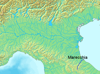
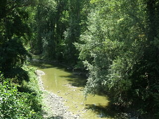
The Marecchia is a river in eastern Italy. In ancient times it was known as the Ariminus which was from the Greek Aríminos. The source of the river is near Monte dei Frati which is east of Pieve Santo Stefano and southwest of Badia Tedalda in the province of Arezzo in Tuscany. It flows northeast into the province of Pesaro and Urbino in the Marche and is the only river that runs through Montefeltro. While flowing through Montefeltro, the river flows through the exclave Santa Sofia Marecchia, which belongs to Badia Tedalda. The river then flows past Sant'Agata Feltria and Novafeltria before crossing into the province of Rimini in Emilia–Romagna. At Torello, part of the commune of San Leo, it flows 1 km west of the Sammarinese territory Acquaviva and the San Marino River flows into it, but the Marecchia does not touch the San Marino border. Finally, the river flows past Verucchio and Santarcangelo di Romagna before flowing into the Adriatic Sea near Rimini.

The Aterno-Pescara is a river system in Abruzzo, eastern central Italy. The river is known as the Aterno near its source in the mountains, but takes the name Pescara, actually a tributary, nearer the city of Pescara and the Adriatic Sea.

Piandimeleto is a comune (municipality) in the Province of Pesaro e Urbino in the Italian region Marche, located about 90 kilometres (56 mi) west of Ancona and about 45 kilometres (28 mi) southwest of Pesaro.

Sassocorvaro is a comune (municipality) in the Province of Pesaro e Urbino in the Italian region Marche, located about 80 kilometres (50 mi) west of Ancona and about 35 kilometres (22 mi) southwest of Pesaro.

The Montone is a river in the historical region of Romagna, which is in the present-day region of Emilia-Romagna in northern Italy. It is the northernmost river on the east-facing slopes of the Apennines to flow directly into the Adriatic Sea rather than entering the Po. Its Latin name was Utis or Vitis.

The Cesano is a river in the Marche region of Italy. Its source is near Monte Catria on the border between the province of Perugia and the province of Pesaro e Urbino. The river flows northeast through Pesaro e Urbino before forming the border between Pesaro e Urbino and the province of Ancona for a short distance. It continues flowing northeast through Pesaro e Urbino and flows past Pergola before becoming the border with Ancona again near San Lorenzo in Campo. The river flows northeast near Mondavio, Corinaldo and Monte Porzio before the province of Ancona extends westward beyond the bank of the river for a short distance near Mondolfo. Finally, the river flows into the Adriatic Sea north of Senigallia and south of Marotta and Fano.

The Tronto is a 115-kilometre (71 mi) long Italian river that arises at Monti della Laga and ends in the Adriatic Sea at Porto d'Ascoli, San Benedetto del Tronto. It traverses the Lazio, Marche, and Abruzzo regions of Italy.

The Foglia is the northernmost river of the Marche region of Italy. In ancient times it was known as Pisaurus, as it debouched into the Adriatic Sea at Pisaurum. It was also known as the Isaurus. The source of the river is west of Sestino in the province of Arezzo in the Appennino Umbro-Marchigiano mountains. It flows east through an extension of the province of Pesaro e Urbino and then back into Arezzo before forming the border between Arezzo and Pesaro e Urbino. The river then flows into the province of Pesaro e Urbino past Piandimeleto and curves northeast and flows past Sassocorvaro before curving east again. The river meanders south of Montecalvo in Foglia before curving northeast and flowing near Colbordolo, Saludecio, Sant'Angelo in Lizzola, Montecchio, Montelabbate and Tavullia before entering the Adriatic Sea near Pesaro.

The Conca is a river in the Marche and Emilia-Romagna regions of Italy. Its source is Monte Carpegna, which is in the Montefeltro part of the province of Pesaro e Urbino. The river flows northeast near Macerata Feltria and Mercatino Conca before crossing into the province of Rimini. The river then flows past Morciano di Romagna before entering the Adriatic Sea southeast of Misano Adriatico and northwest of Cattolica.

Monte dei Frati is a mountain in the Italian province of Arezzo near the border with Pesaro e Urbino and Perugia.
The Tavo is a river in the Abruzzo region of Italy. Its source is in the Gran Sasso d'Italia mountain range in the province of L'Aquila near the border with the province of Pescara. After crossing the border, the river loops northward and then eastward near Penne. It then flows south and then northeast and flows near Loreto Aprutino and Pianella. The river continues flowing northeast near Cappelle sul Tavo before joining the Fino and together they become the Saline.

The Tenna is a river in the Marche region of Italy. Its source is in the Sibillini Mountains in the province of Fermo near the border with the province of Macerata. It flows northeast through the mountains near Montefortino and Amandola before forming the border between the provinces of Fermo and Macerata. The river enters the province of Fermo near Servigliano and continues flowing northeast past Grottazzolina and Montegiorgio. Finally, the river enters the Adriatic Sea near Sant'Elpidio a Mare and Porto Sant'Elpidio.

The Candigliano is a river in the Marche and Umbria regions of Italy. Its source is in the Appennino Umbro-Marchigiano mountains in the province of Pesaro e Urbino near the border with the province of Perugia. The river flows east and forms the border between Pesaro e Urbino and Perugia for a short distance south of Mercatello sul Metauro before entering Pesaro e Urbino. It then continues flowing east past an exclave called Monte Ruperto belonging to Città di Castello and then past Piobbico, where it is joined by the Biscubio. The river is joined by the Burano at Acqualagna and flows northeast near the Furlo Pass until it joins the Metauro west of Fossombrone.
The Burano is a river in the Umbria and Marche regions of Italy. Its source is in the province of Perugia in the Appennino Umbro-Marchigiano mountains. The river crosses the border into the province of Pesaro e Urbino and flows north near Monte Catria, Cantiano, Monte Nerone, and Cagli before entering the Candigliano at Acqualagna.

The Idice is a river in the Tuscany and Emilia-Romagna regions of Italy. The source of the river is in the province of Florence near Monghidoro in the Appennino Tosco-Emiliano mountains. The river flows north into the province of Bologna near Monterenzio before being joined by the Savena east of Bologna. The river then curves eastward and flows near Castenaso and Budrio before flowing into the province of Ferrara. It then flows into the Reno near where the Sillaro enters the Reno southeast of Argenta.
The Savena is a river in the Tuscany and Emilia-Romagna regions of Italy. The source of the river is in the province of Florence west of Firenzuola in the Appennino Tosco-Emiliano mountains. The river flows north into the province of Bologna and flows near Monghidoro, Loiano, Pianoro and San Lazzaro di Savena before curving east and flowing into the Idice east of Bologna.
References
- ↑ Hammond World Atlas (6 ed.). Hammond World Atlas Corporation. 2010. p. 69. ISBN 9780843715606.
| This Umbria location article is a stub. You can help Wikipedia by expanding it. |
| This Marche location article is a stub. You can help Wikipedia by expanding it. |
| This article related to a river in Italy is a stub. You can help Wikipedia by expanding it. |