
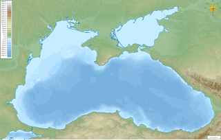
The Black Sea is a marginal mediterranean sea lying between Europe and Asia, east of the Balkans, south of the East European Plain, west of the Caucasus, and north of Anatolia. It is bounded by Bulgaria, Georgia, Romania, Russia, Turkey, and Ukraine. The Black Sea is supplied by major rivers, principally the Danube, Dnieper and Dniester. Consequently, while six countries have a coastline on the sea, its drainage basin includes parts of 24 countries in Europe.
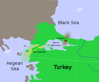
The Bosporus or Bosphorus Strait is a natural strait and an internationally significant waterway located in Istanbul, Turkey. The Bosporus connects the Black Sea to the Sea of Marmara and forms one of the continental boundaries between Asia and Europe. It also divides Turkey by separating Anatolia from Thrace. It is the world's narrowest strait used for international navigation.

The Strait of Gibraltar is a narrow strait that connects the Atlantic Ocean to the Mediterranean Sea and separates Europe from Africa. The two continents are separated by 13 kilometres of ocean at the Strait's narrowest point between Punta de Tarifa in Spain and Point Cires in Morocco. Ferries cross between the two continents every day in as little as 35 minutes. The Strait's depth ranges between 300 and 900 metres.
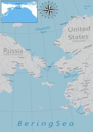
The Bering Strait is a strait between the Pacific and Arctic oceans, separating the Chukchi Peninsula of the Russian Far East from the Seward Peninsula of Alaska. The present Russia-United States maritime boundary is at 168° 58' 37" W longitude, slightly south of the Arctic Circle at about 65° 40' N latitude. The Strait is named after Vitus Bering, a Danish explorer in the service of the Russian Empire.

The Sea of Azov is an inland shelf sea in Eastern Europe connected to the Black Sea by the narrow Strait of Kerch, and is sometimes regarded as a northern extension of the Black Sea. The sea is bounded by Russia on the east, and by Ukraine on the northwest and southwest, currently under Russian occupation. It is an important access route for Central Asia, from the Caspian Sea via the Volga–Don Canal.
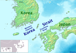
The Korea Strait is a sea passage in East Asia between Korea and Japan, connecting the East China Sea, the Yellow Sea and the Sea of Japan in the northwest Pacific Ocean. The strait is split by the Tsushima Island into the Western Channel and the Tsushima Strait or Eastern Channel. It is economically important, as many shipping lanes pass through the strait, and both Japan and Korea permit free passage through it. In ancient times, both Buddhism and Mongol invaders passed over the strait to reach Japan. More recently, it was the site of the Battle of Korea Strait in the Korean War. A tunnel running underneath the strait connecting Japan and Korea, the Japan–Korea Undersea Tunnel, has been proposed to connect the two countries.

The Labrador Sea is an arm of the North Atlantic Ocean between the Labrador Peninsula and Greenland. The sea is flanked by continental shelves to the southwest, northwest, and northeast. It connects to the north with Baffin Bay through the Davis Strait. It is a marginal sea of the Atlantic.
The Black Sea deluge is the best known of three hypothetical flood scenarios proposed for the Late Quaternary history of the Black Sea. One other flood scenario proposes a rapid, even catastrophic, rise in sea level of the Black Sea.
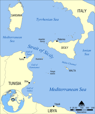
The Strait of Sicily is the strait between Sicily and Tunisia. The strait is about 145 kilometres (90 mi) wide and divides the Tyrrhenian Sea and the western Mediterranean Sea, from the eastern Mediterranean Sea. The maximum depth is 316 meters (1,037 ft). The island of Pantelleria lies in the middle of the strait.

The Aquarius Reef Base is an underwater habitat located 5.4 mi (8.7 km) off Key Largo in the Florida Keys National Marine Sanctuary, Florida, United States. It is the world's only undersea research laboratory and it is operated by Florida International University. It is deployed on the ocean floor 62 ft (19 m) below the surface and next to a deep coral reef named Conch Reef.
A Bering Strait crossing is a hypothetical bridge or tunnel that would span the relatively narrow and shallow Bering Strait between the Chukotka Peninsula in Russia and the Seward Peninsula in the U.S. state of Alaska. The crossing would provide a connection linking the Americas and Afro-Eurasia.

Kiten is a seaside resort town on the Bulgarian Black Sea Coast, part of Burgas Province. It is situated on the small Urdoviza peninsula, near the mouth of the Kiten River, and has two beaches: Atliman and Urdoviza.
Lake Manych-Gudilo is a large saltwater reservoir lake in Kalmykia, Russia. Part of the lake lies also in Rostov Oblast and Stavropol Krai. It has an area of about 344 km² and average depth of only about 0.6 m.
An underwater tunnel is a tunnel which is partly or wholly constructed under the sea or a river. They are often used where building a bridge or operating a ferry link is unviable, or to provide competition or relief for existing bridges or ferry links. While short tunnels are often road tunnels which may admit motorized traffic, unmotorized traffic or both, concerns with ventilation lead to the longest tunnels being electrified rail tunnels.
A fixed link or fixed crossing is a permanent, unbroken road or rail connection across water that uses some combination of bridges, tunnels, and causeways and does not involve intermittent connections such as drawbridges or ferries. A bridge–tunnel combination is commonly used for major fixed links.

The following outline is provided as an overview of and introduction to Oceanography.
The Bosphorus Water Tunnel or Bosporus aqueduct is an undersea aqueduct in Istanbul, Turkey, crossing the Bosphorus strait. It was constructed in 2012 to transfer water from the Melen Creek in Düzce Province to the European side of Istanbul.
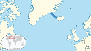
The Denmark Strait overflow is an undersea overflow located in the Denmark Strait between Greenland and Iceland. The overflow transports around 3.2 million m3 (110 million cu ft) of water per second, greatly eclipsing the discharge of the Amazon River into the Atlantic Ocean and the flow rate of the former Guaíra Falls. The descending column of water is approximately 200 m (660 ft) wide and 200 m (660 ft) thick and descends over a length of around 1,000 km (620 mi). It is formed by the density difference of the water masses either side of the Denmark Strait; the southward-flowing water originating from the Nordic Seas is colder and consequently more dense than the Irminger Sea to the south of the strait. At the Greenland–Iceland Rise – an elevated ridge forming the overflow's apex – the colder water cascades along the seafloor to a depth of around 3,000 m (10,000 ft). Due to the Coriolis effect, the downward flow of water is deflected to the right, resulting in the descending water on the Greenland side of the channel being roughly 1 km (0.62 mi) higher than the opposite side of the channel.

Juan de Fuca Channel is a submarine channel off the shore of Washington state, United States and the Strait of Juan de Fuca.
