
Brighouse is a town within the metropolitan borough of Calderdale, in West Yorkshire, England. Historically within the West Riding of Yorkshire, it is situated on the River Calder, 4 miles (6.4 km) east of Halifax. It is served by Junction 25 of the M62 motorway and Brighouse railway station on the Caldervale Line and Huddersfield Line. In the town centre is a mooring basin on the Calder and Hebble Navigation. The United Kingdom Census 2001 gave the Brighouse / Rastrick subdivision of the West Yorkshire Urban Area a population of 32,360. The Brighouse ward of Calderdale Council gave a population of 11,195 at the 2011 Census. Brighouse has a HD6 postcode.

Elland is a market town in Calderdale, in the county of West Yorkshire, England. It is situated south of Halifax, by the River Calder and the Calder and Hebble Navigation. Elland was recorded as Elant in the Domesday Book of 1086. It had a population in 2001 of 14,554, with the ward being measured at 11,676 in the 2011 Census.

Ripponden is a village and civil parish on the River Ryburn near Halifax in West Yorkshire, England. Historically it was part of the West Riding of Yorkshire. Its population was 6,412 at the time of the 2001 Census, and 7,421 in 2011.

Calderdale is a metropolitan borough of West Yorkshire, England, which had a population of 211,439. It takes its name from the River Calder, and dale, a word for valley. The name Calderdale usually refers to the borough through which the upper river flows, while the actual landform is known as the Calder Valley. Several small valleys contain tributaries of the River Calder. The main towns of the borough are Brighouse, Elland, Halifax, Hebden Bridge, Sowerby Bridge and Todmorden.

The City of Bradford is a local government district of West Yorkshire, England, with the status of a city and metropolitan borough. It is named after its largest settlement, Bradford, but covers a large area which includes the towns and villages of Keighley, Shipley, Bingley, Ilkley, Haworth, Silsden, Queensbury, Thornton and Denholme. Bradford has a population of 528,155, making it the fourth-most populous metropolitan district and the sixth-most populous local authority district in England. It forms part of the West Yorkshire Urban Area conurbation which in 2011 had a population of 1,777,934, and the city is part of the Leeds-Bradford Larger Urban Zone (LUZ), which, with a population of 2,393,300, is the fourth largest in the United Kingdom after London, Birmingham and Manchester.

Clayton is a village in the west of the Metropolitan Borough of Doncaster, South Yorkshire, England, on the border with West Yorkshire. It lies to the north of Thurnscoe at an elevation of around 80 metres above sea level.

A civil parish is a subnational entity, forming the lowest unit of local government in England. There are 101 civil parishes in the ceremonial county of West Yorkshire, most of the county being unparished. At the 2001 census, there were 557,369 people living in the parishes, accounting for 26.8 per cent of the county's population.

Fenwick is a small village and civil parish in the Metropolitan Borough of Doncaster, on the border with North Yorkshire. It was historically part of the West Riding of Yorkshire until 1974. It is located at an elevation of around 6 metres above sea level and had a population of 113, increasing slightly to 121 at the 2011 Census. The northern boundary of the parish is marked by the River Went.

Queensbury is a large village in the metropolitan borough of Bradford, West Yorkshire, England. Perched on a high vantage point above Halifax, Clayton and Thornton and overlooking Bradford itself, Queensbury is one of the highest parishes in England, with views beyond the West Yorkshire conurbation to the hills of Brontë Country and the Yorkshire Dales to the north and north west. It had a population of 8,718 in 2001 which increased to 16,273 in the 2011 Census.

Badsworth is a village and civil parish in the City of Wakefield metropolitan borough in West Yorkshire, England. According to the 2001 census it had a population of 583, increasing to 682 at the 2011 Census. The village is located 6 miles (9.7 km) south of Pontefract.
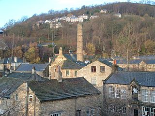
Hebden Royd is a civil parish in the Metropolitan Borough of Calderdale in West Yorkshire, England. According to the 2001 census it had a population of 9,092, rising to 9,558 at the 2011 census. It includes market town of Hebden Bridge and the villages of Mytholmroyd and Cragg Vale. The parish was an urban district before 1974, created in 1937 by the merger of Hebden Bridge and Mytholmroyd urban districts.
Billingley is a village and civil parish in the Metropolitan Borough of Barnsley, in South Yorkshire, England, 7 miles (11 km) east of Barnsley. At the 2001 census it had a population of 177, increasing to 210 at the 2011 Census.
Steeton with Eastburn is a civil parish within the City of Bradford Metropolitan District, West Yorkshire, England. Historically part of the West Riding of Yorkshire, it has, according to the 2001 census, a population of 4,277, increasing to 4,375 at the 2011 Census. The parish includes the villages of Steeton and Eastburn.
Hepton was a rural district in the West Riding of Yorkshire, England, from 1894 to 1974.

Shelf is a village in Calderdale in West Yorkshire, England. The village is situated approximately 3 miles (4.8 km) north-east of Halifax and 5 miles (8 km) south-west of Bradford, on the A6036 road. In 2001 it had a population of 4,496. At the 2011 Census Shelf was measured as part of the Calderdale ward of Northowram and Shelf.
Dunford is a civil parish in the Metropolitan Borough of Barnsley, 14.5 miles (23.3 km) northwest of Sheffield in South Yorkshire, England. It lies in the Peak District and within the Metropolitan Borough of Barnsley. The population of the civil parish as of the 2011 census was 568. The parish is centred on Dunford Bridge to the west and Lower Cumberworth to the east with Crow Edge virtually central between them.

Wadsworth is a civil parish in the Metropolitan Borough of Calderdale in West Yorkshire, England. It has a population of 1,456, increasing to 1,603 at the 2011 Census, and was, until 1974, part of Hepton Rural District.

Erringden is a civil parish in the Metropolitan Borough of Calderdale in West Yorkshire, England. Previously it was a township within the chapelry of Heptonstall.

The City of Leeds is a city and metropolitan borough in West Yorkshire, England. The metropolitan borough includes the administrative centre of Leeds and the towns of Farsley, Garforth, Guiseley, Horsforth, Morley, Otley, Pudsey, Rothwell, Wetherby and Yeadon. It has a population of 811,956 (2021), making it technically the second largest city in England by population behind Birmingham, since London is not a single local government entity. Local governance sits with Leeds City Council and the city's 32 Parish Councils.

Lotherton cum Aberford is a civil parish in the metropolitan borough of Leeds in West Yorkshire, England. The population of the civil parish at the 2011 Census was 323. Until 1974 it was in the Tadcaster Rural District in the West Riding of Yorkshire.

