
Pinellas County is a county located on the west central coast of the U.S. state of Florida. As of the 2020 census, the population was 959,107. It is the most densely populated county in Florida. The county is part of the Tampa–St. Petersburg–Clearwater, Florida Metropolitan Statistical Area. Clearwater is the county seat. St. Petersburg is the largest city as well as the largest city in Florida that is not a county seat.
Gulfport is a city in Pinellas County, Florida, United States, bordering St. Petersburg, South Pasadena, and Boca Ciega Bay. The population of Gulfport was 12,029 at the 2010 census. Gulfport is part of the Tampa–St. Petersburg–Clearwater metropolitan statistical area.

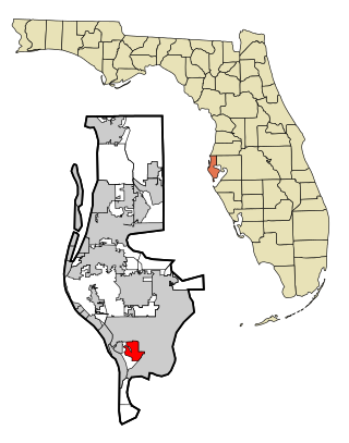
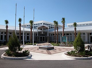
Seminole is a city in Pinellas County, Florida, United States. The population was 19,364 at the 2020 census.
St. Pete Beach is a coastal city in Pinellas County, Florida. Known as a tourist destination, St. Pete Beach was formed from the towns of Pass-a-Grille, Belle Vista, St. Petersburg Beach and unincorporated Pinellas County.The population was 9,346 at the 2010 census.

Biscayne National Park is an American national park located south of Miami, Florida in Miami-Dade County. The park preserves Biscayne Bay and its offshore barrier reefs. Ninety-five percent of the park is water, and the shore of the bay is the location of an extensive mangrove forest. The park covers 172,971 acres and includes Elliott Key, the park's largest island and northernmost of the true Florida Keys, formed from fossilized coral reef. The islands farther north in the park are transitional islands of coral and sand. The offshore portion of the park includes the northernmost region of the Florida Reef, one of the largest coral reefs in the world.

Pine Island Sound is located in Lee County, Florida, lying between Pine Island and the barrier islands of Sanibel Island, Captiva Island, North Captiva Island and Cayo Costa, which separate the Sound from the Gulf of Mexico. The Sound connects to Gasparilla Sound and Charlotte Harbor to the north, and to San Carlos Bay and the Caloosahatchee River to the south. The Sound is conterminous with the Pine Island Sound Aquatic Preserve, which was established in 1970 and consists of 54,000 acres (220 km2) of submerged land. Important habitats in the Sound include mangroves, seagrasses, salt marshes, oyster communities, tidal flats and sponge beds. All animals in and around Pine Island sound, including mollusks, fish, birds and mammals, are affected by periodic outbreaks of red tide. The Sound is relatively shallow in many locations, and boaters are cautioned to utilize up-to-date charts and tide tables.
The Pinellas Bayway System is a series of bridges on two state roads in Pinellas County, Florida. It is a toll road complex maintained and operated by the Florida Department of Transportation. It also is compatible with the SunPass ETC system currently in use on all other FDOT-owned toll roads. The Pinellas Bayway consists of:

Treasure Island Causeway is a series of three bridges crossing Boca Ciega Bay between Treasure Island and St. Petersburg in Pinellas County, Florida. The bridge, which carries County Road 150 (CR 150), is owned and maintained by the City of Treasure Island, which used to charge all motorists $1.00 toll, until June, 2006, when the first span of the bridge was reopened with no toll booth. Residents of two St. Petersburg waterfront communities used to pay a $10 annual road tax to the City of Treasure Island to help support road and median maintenance. That tax was eliminated in the spring of 2007. Treasure Island's ownership of the causeway in St. Petersburg was part of a land agreement entered into when these two cities were born: St. Petersburg's founding fathers purchased the Municipal Beach on the shores of the neighboring Gulf of Mexico community, Treasure Island, outside its own city limits to ensure that residents would have direct access to the Gulf of Mexico for generations to come. The western terminus is an intersection with Gulf of Mexico Boulevard in Treasure Island.

The Jungle Prada Site is an archaeological site featuring Indigenous Tocobaga mounds and the location of the historical Narváez expedition landing. The Jungle Prada site spans public and private property, including the Jungle Prada de Narvaez city park, in St. Petersburg of Pinellas County, western coastal Florida, in the Southern United States.

The Weedon Island Preserve is a 3,190 acre natural area situated along the western shore of Tampa Bay, and located on 1800 Weedon Drive NE. St. Petersburg, Florida, United States. It is predominately an estuarine preserve composed of upland and aquatic ecosystems such as mangrove forests, pine/scrubby flatwoods, and maritime hammock, and is home to a variety of native wildlife. The preserve is also a designated archaeological area with several shell mounds identified on the property that provide evidence of early peoples who inhabited the land for thousands of years.
Rookery Bay Reserve protects 110,000 acres of coastal lands and waters at the northern end of the Ten Thousand Islands on the gulf coast of Florida, Rookery Bay National Estuarine Research Reserve represents one of the few remaining undisturbed mangrove estuaries in North America.
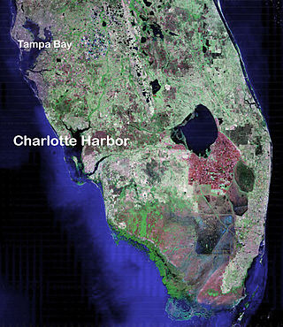
Charlotte Harbor Estuary, the second largest bay in Florida, is located on the Gulf of Mexico coast of west Florida with two thirds lying in Charlotte County, Florida and one in Lee County. The harbor's mouth is located behind Gasparilla Island, one of the many coastal barrier islands on the southwest coast of Florida, with access from the Gulf of Mexico through the Boca Grande Pass between Gasparilla Island on the north and Lacosta Island on the south. Charlotte Harbor covers about 270 sq mi (700 km2)
In 1999, the Guana Tolomato Matanzas National Estuarine Research Reserve was designated in St. Johns and Flagler counties, Florida as a part of the National Oceanic and Atmospheric Administration (NOAA) National Estuarine Research Reserve (NERR) system. The GTM Research Reserve represents the east Florida sub-region of the Carolinian bioregion. It is one of 29 NERRs in 23 states and one territory. GTM is one of three NERRs in Florida, and is administered on behalf of the state by the Florida Department of Environmental Protection's Florida Coastal Office as part of a network that includes forty-one aquatic preserves, three NERRs, a National Marine Sanctuary, the Coral Reef Conservation Program and the Florida Oceans and Coastal Council. Additional interests are held in the research and management of the GTM and connected preserved or conserved lands including:

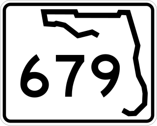
State Road 666 (SR 666) is a short state road in Pinellas County. Locally known as Tom Stuart Causeway, Welch Causeway, or Madeira Beach Causeway, the route crosses Boca Ciega Bay from Seminole to Madeira Beach. The bridge crossing Boca Ciega Bay is a bascule bridge with 11 spans, built in 1962. The route ends with an interchange with U.S. Route 19 Alternate in Bay Pines. The southwestern terminus of the route is at State Road 699 in Madeira Beach, in front of the Ocean Sands hotel.
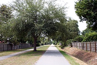
The Fred Marquis Pinellas Trail is a rail trail in Pinellas County, Florida. It stretches from Tarpon Springs in the north to St. Petersburg in the south, passing through the towns of Palm Harbor, Dunedin, Belleair, Clearwater, Largo, Seminole, South Pasadena, and Gulfport. It is utilized for walking, jogging, and cycling. Some trail users are able to commute to work using the Pinellas Trail instead of a motor vehicle.

Bayway Isles is a residential neighborhood consisting of two islands in the southwestern part of the city of St. Petersburg, Florida. The islands are home to almost 200 families. The community extends southward from the Pinellas Bayway causeway into the waters of southern Boca Ciega Bay. Bayway Isles is a guarded, deed-restricted community.

Bear Creek is an unincorporated community and census-designated place (CDP) in Pinellas County, Florida, United States. The population was 1,948 at the 2010 census.
Lemon Bay is a long, narrow and shallow body of water covering 8,000 acres in Charlotte County, Florida and Sarasota County, Florida. It is protected as the Lemon Bay Aquatic Preserve, designated in 1986. It is one of five Charlotte Harbor Aquatic Preserves. The bay is fed by one Gulf pass, Stump Pass, and seven tributaries and includes areas of mangrove, marsh grass, and seagrass. It provides habitat for bird, invertebrate and fish species and offers fishing, kayaking, birding, wading and beachcombing opportunities.

Clam Bayou is a 170-acre estuary between Gulfport, Florida, St. Petersburg, Florida, and Boca Ciega Bay. The neighborhood around the estuary is also known as Clam Bayou. The area is popular with kayakers. It is also home to the 10-acre Clam Bayou Nature Park that includes a canoe and kayak launch point.

Weedon Island is located in Pinellas County, Florida, United States. It is located within the Weedon Island Preserve, in the northern portion of the city of St. Petersburg, on the western coast of Old Tampa Bay. Weedon Island is archaeologically significant as it serves as a type-site for the Weeden Island Culture. Weedon Island is named for its early owner Dr. Leslie Weedon.

