Bonita Springs, Florida

Last updated

Bonita Springs, Florida
Bonita Beach.JPG
Bonita Beach
Seal of Bonita Springs, Florida.png
Etymology: Spanish: bonita (beautiful), English: beautiful springs
Nickname: 
Gateway to the Gulf
Motto(s): 
"Small Town Charm, Big Bright Future"
Lee County Florida Incorporated and Unincorporated areas Bonita Springs Highlighted.svg
Location in Lee County and the U.S. state of Florida
Coordinates: 26°20′59″N81°47′27″W / 26.34972°N 81.79083°W / 26.34972; -81.79083
CountryUnited States
State Florida
County Lee
Settled
(Town of Survey)
Late 1800s-1912 [1] [2]
Incorporated (city) 1925-1932 [1] [2]
Reincorporated (city) December 31, 1999 (1999-12-31) [1] [2] [3]
Government
  Type Council-Manager
   Mayor Rick Steinmeyer
   Councilors Jamie Bogacz,
Jesse Purdon,
Laura Carr, Chris Corrie,
Nigel P. Fullick, and
Fred Forbes
   City Manager Arleen Hunter
   City Clerk Mike Sheffield
   City Attorney Derek Rooney
Area
[4]
   City 46.51 sq mi (120.47 km2)
  Land38.42 sq mi (99.50 km2)
  Water8.09 sq mi (20.96 km2)  13.95%
Elevation
10 ft (3 m)
Population
 (2020)
   City 53,644
  Density1,396.32/sq mi (539.12/km2)
   Urban
425,675 (US: 97th) [5]
  Urban density1,752.0/sq mi (676.5/km2)
Time zone UTC-5 (Eastern (EST))
  Summer (DST) UTC-4 (EDT)
ZIP codes
34133-34136
Area code 239
FIPS code 12-07525 [6]
GNIS feature ID0279207 [7]
Website www.cityofbonitasprings.org

Bonita Springs is a city in Lee County, Florida, United States. The population was 53,644 at the 2020 census, [8] up from 43,914 at the 2010 census. It is part of the Cape Coral-Fort Myers, Florida Metropolitan Statistical Area, on the state's southwest coast.

Contents

History

Bonita Springs' history dates back approximately 8,000 years, with evidence of early inhabitants including the Calusa Indians. [9] In the 1870s, the US Army Corps of Engineers surveyed the area, establishing a camp along what is now the Imperial River. This site became known as Survey, and the river was called Surveyor's Creek. [10] [11]

In the 1880s, Braxton Comer bought 6,000 acres around Survey and brought indentured families to work on his plantation. [12] By the early 20th century, developers decided to rename the area Bonita Springs to make it more appealing to settlers and investors. [13] By 1912, streets and avenues were laid out, and the names Survey and Surveyor's Creek were changed to Bonita Springs and the Imperial River, respectively. [14]

The completion of a road to Fort Myers in 1917 and the extension of the Fort Myers-Southern Railroad to Bonita Springs in the 1920s spurred significant growth. [15] [16] The Tamiami Trail, completed in 1928, further contributed to this development. [17] During this time, Bonita Springs experienced a land boom, leading to the establishment of citrus groves and various tourist attractions, including the Everglades Wonder Gardens and the Shell Factory. [18] [19] [20]

The advent of air conditioning, the construction of Interstate 75, and the opening of Southwest Florida International Airport in the late 20th century brought more tourists and retirees to Bonita Springs. Today, it is known for its beautiful beaches, luxury golf courses, and a thriving community, attracting both residents and businesses. [21] [22]

Geography

Bonita Springs's approximate coordinates are 26°20′59″N81°47′27″W / 26.34972°N 81.79083°W / 26.34972; -81.79083 .

According to the United States Census Bureau, the city has an area of 41.0 square miles (106 km2), of which 35.3 square miles (91 km2) is land and 5.7 square miles (15 km2) (13.95%) is water.

The city is on both Estero Bay and the Gulf of Mexico. The area called Bonita Beach is on Little Hickory Island, a road-accessible barrier island that lies between the Gulf of Mexico and Estero Bay. The Imperial River flows through the city's downtown district and empties into Estero Bay.

Climate

The city lies in the tropical climate zone, more specifically a tropical monsoon climate (Köppen climate classification: Am), having a mean January temperature of 65 °F (18 °C).

Hurricane Charley made landfall north of Bonita Springs on August 13, 2004. Hurricane Wilma made landfall south of Bonita Springs on October 24, 2005. On September 9–10, 2017, Hurricane Irma, at the time a slow-moving Category 3 storm, passed over Florida's southwest coast. The eyewall/eye passed overhead in Bonita Springs. Many structures were damaged or destroyed and the city experienced significant flooding.

Demographics

Historical population
CensusPop.Note
1940 356
1970 1,932
1980 5,435181.3%
1990 13,600150.2%
2000 32,797141.2%
2010 43,91433.9%
2020 53,64422.2%
source: [23] [24]

2010 and 2020 census

Bonita Springs racial composition
(Hispanics excluded from racial categories)
(NH = Non-Hispanic)
RacePop 2010 [25] Pop 2020 [26] % 2010% 2020
White (NH)32,98039,70375.10%74.01%
Black or African American (NH)2894700.66%0.88%
Native American or Alaska Native (NH)58530.13%0.09%
Asian (NH)4337540.99%1.41%
Pacific Islander or Native Hawaiian (NH)14300.03%0.06%
Some other race (NH)361990.08%0.37%
Two or more races/Multiracial (NH)2271,0630.52%1.98%
Hispanic or Latino (any race)9,87711,37222.49%21.20%
Total43,91453,644100.00%100.00%

As of the 2020 United States census, there were 53,644 people, 24,377 households, and 16,267 families residing in the city. [27]

As of the 2010 United States census, there were 43,914 people, 19,137 households, and 12,917 families residing in the city. [28]

2000 census

The 2009 estimated median income for a household in the city was $53,452, and the median income for a family was $53,436. Males had a median income of $31,227 versus $25,358 for females. The per capita income for the city was $37,958. About 6.2% of families and 10% of the population were below the poverty line, including 20.2% of those under age 18 and 5.2% of those aged 65 or over.

In 2009, 16.7% of households had children under the age of 18 living with them, 61.2% were married couples living together, 4.1% had a female householder with no husband present, and 32.5% were non-families. 27.1% of all households were made up of individuals, and 11.6% had someone living alone who was 65 years of age or older. The average household size was 2.15 and the average family size was 2.55.

As of 2000, the population density was 929.4 inhabitants per square mile (358.8/km2). There were 31,716 housing units at an average density of 661.1 per square mile (255.3/km2).

In 2000, the city the population was spread out, with 13.9% under the age of 18, 5.9% from 18 to 24, 19.8% from 25 to 44, 28.8% from 45 to 64, and 31.7% who were 65 years of age or older. The median age was 54 years. For every 100 females, there were 104.6 males. For every 100 females aged 18 and over, there were 103.9 males.

Arts and Culture

Bonita Springs boasts a rich cultural scene with institutions like the Centers for the Arts Bonita Springs, which offers art classes, exhibitions, and performances. The city hosts several annual events, including the Celebrate Bonita festival and various arts and craft fairs. [29]

The Bonita Springs Historical Society offers walking tours that highlight the city’s historical sites, such as the Liles Hotel and the Bonita Springs Elementary School. These tours provide insights into the area's past and its development over the years. [30] [31]

Public art is an integral part of the city’s cultural landscape, with numerous sculptures and murals adorning public spaces. The Everglades Wonder Gardens, a historic attraction, continues to draw visitors with its botanical garden and wildlife exhibits. [32] [33]

Education

Bonita Springs is served by the Lee County School District.

Elementary schools

Middle school

High school

Charter schools

Private schools

Higher learning

Transportation

Airports

Major highways

Mass transportation

Fixed-route bus and trolley service is provided by the Lee County Transit Department, operated as LeeTran.

Rail

Seminole Gulf Railway owns and operates a line that passes through the city. The company offers freight service and local, daytime excursions.

Media

Newspapers

Bonita Springs is served by local editions of the Fort Myers News-Press and Naples Daily News .

Radio

The metropolitan area is home to 36 radio stations. With an Arbitron-assigned 879,600 listening area population, the metropolitan area of which Bonita Springs is one part ranks 61/274 for the fall of 2013. Arbitron Standard Radio Market: Ft. Myers-Naples-Marco Island. [34]

Television

Nielsen Media Research designated market area: Ft. Myers-Naples. [35]

2013 - 2014 estimate U.S. rank: 62/210 (517,920 TV Homes)

Points of interest

Barefoot Beach, a former recipient of a top beach award, is located within the community. BarefootBeachFL.jpg
Barefoot Beach, a former recipient of a top beach award, is located within the community.
Bonita Beach, as seen from the Gulf of Mexico Bonita Beachfront.JPG
Bonita Beach, as seen from the Gulf of Mexico

Related Research Articles

<span class="mw-page-title-main">Broward County, Florida</span> County in Florida, United States

Broward County is a county in the southeastern part of Florida, located in the Miami metropolitan area. It is Florida's second-most populous county after Miami-Dade County and the 17th-most populous in the United States, with 1,944,375 residents as of the 2020 census. Its county seat and most populous city is Fort Lauderdale, which had a population of 182,760 as of 2020.

<span class="mw-page-title-main">Collier County, Florida</span> County in Florida, United States

Collier County is a county in the U.S. state of Florida. As of the 2020 census, its population was 375,752; an increase of 16.9% since the 2010 United States Census. Its county seat is East Naples, where the county offices were moved from Everglades City in 1962.

<span class="mw-page-title-main">Glades County, Florida</span> County in Florida, United States

Glades County is a county located in the Florida Heartland region of the U.S. state of Florida. As of the 2020 census, the population was 12,126, making it the fourth-least populous county in Florida. Its county seat is Moore Haven.

<span class="mw-page-title-main">Hendry County, Florida</span> County in Florida, United States

Hendry County is a county in the Florida Heartland region of the U.S. state of Florida. As of the 2020 census, the population was 39,619, down from 42,022 at the 2010 census. Its county seat is LaBelle.

<span class="mw-page-title-main">Lee County, Florida</span> County in Florida, United States

Lee County is located in southwestern Florida, United States, on the Gulf Coast. As of the 2020 census, its population was 760,822. In 2022, the population was 822,453, making it the eighth-most populous county in the state. The county seat is Fort Myers, with a population of 86,395 as of the 2020 census, and the largest city is Cape Coral, with an estimated 2020 population of 194,016.

<span class="mw-page-title-main">Chokoloskee, Florida</span> Census-designated place in Florida

Chokoloskee is an unincorporated community and census-designated place (CDP) located at the edge of the Ten Thousand Islands in Collier County, Florida, United States. The population was 345 at the 2020 census, down from 359 at the 2010 census. It is part of the Naples–Marco Island Metropolitan Statistical Area.

<span class="mw-page-title-main">Everglades City, Florida</span> City in Florida

Everglades City is a city in Collier County, Florida, United States, of which it was once the county seat. The City of Everglades City is part of the Naples–Marco Island Metropolitan Statistical Area, which is included in the Cape Coral-Fort Myers-Naples Combined Statistical Area. The Gulf Coast Visitor Center for Everglades National Park is located in Everglades City. As of the 2020 US census, the population was 352, down from 400 in the 2010 US census.

<span class="mw-page-title-main">Marco Island, Florida</span> City in Florida, United States

Marco Island is a city and barrier island in Collier County, Florida, 20 miles (32 km) south of Naples on the Gulf Coast of the United States. It is the largest barrier island in Southwest Florida's Ten Thousand Islands area, which extends southerly to Cape Sable. Marco Island is home to an affluent beach community with resort amenities.

<span class="mw-page-title-main">Naples, Florida</span> City in Florida, United States

Naples is a city in Collier County, Florida, United States. As of the 2020 census, the population was 19,115, down from 19,539 at the 2010 census. Naples is a principal city of the Naples–Marco Island metropolitan area, which had a population of about 375,752 as of 2020. Naples' USPS City population includes most of the communities in Collier County with the notable exceptions of Immokalee, Marco Island, Ave Maria, Everglades City, and a few others, and thus Naples' USPS City population is approximately 333,083.

<span class="mw-page-title-main">Avon Park, Florida</span> City in Florida, United States

Avon Park is a city in Highlands County, Florida, United States. As of the 2020 census, the population was 9,658, up from 8,836 at the 2010 census but down from the 2018 estimated population of 10,695. It is part of the Sebring, Florida Metropolitan Statistical Area. It is the oldest city in Highlands County, and was named after Stratford-upon-Avon, England.

<span class="mw-page-title-main">Sebring, Florida</span> City in Florida, United States of America

Sebring is a city in south-central Florida, United States, nicknamed "The City on the Circle", in reference to Circle Drive, the center of the Sebring Downtown Historic District. It is the county seat of Highlands County, and is the principal city of the Sebring, Florida Metropolitan Statistical Area. As of 2022 United States Census estimates, the population is 11,379, up from 10,729 at the 2020 census. The broader Sebring metropolitan area had a population estimate of 105,618 in 2022, making it the least populous metropolitan statistical area in the state of Florida. The disparity in population between the city proper and the metropolitan area is due to the relatively small size of the annexed area of the city, with most all of the landmass west of Lake Jackson technically in unincorporated Highlands County

<span class="mw-page-title-main">Estero, Florida</span> Village in Florida, United States

Estero is an incorporated village in Lee County, Florida, United States, located directly beside the first aquatic nature preserve established in Florida: The Estero Bay Aquatic Preserve, otherwise referred to as Estero Bay Preserve State Park which is within Estero Bay, Florida. At the time of the 2010 census, Estero was an unincorporated community and census-designated place, but incorporated as a village on the last calendar date of 2014. It is part of the Cape Coral-Fort Myers, Florida Metropolitan Statistical Area. As of the 2020 census, the population was 36,939.

<span class="mw-page-title-main">Fort Myers, Florida</span> City in Florida, United States

Fort Myers is a city in and the county seat of Lee County, Florida, United States. The Census Bureau's Population Estimates Program calculated that the city's population was 95,949 in 2022, ranking the city the 370th-most-populous in the country. Together with the larger and more residential city of Cape Coral, the smaller cities of Fort Myers Beach, Sanibel, and Bonita Springs, the village of Estero, and the unincorporated districts of Lehigh Acres and North Fort Myers, it anchors the Cape Coral-Fort Myers, FL metropolitan statistical area (MSA) which comprises Lee County and has a population of 834,573 as of 2023.

<span class="mw-page-title-main">San Carlos Park, Florida</span> Census-designated place in Florida, United States

San Carlos Park is a census-designated place (CDP) in Lee County, Florida, United States. The population was 18,563 at the 2020 census, up from 16,824 at the 2010 census. It is part of the Cape Coral-Fort Myers, Florida Metropolitan Statistical Area.

<span class="mw-page-title-main">Greenacres, Florida</span> City in Florida, United States

Greenacres is a city in Palm Beach County, Florida, United States. It is part of the Miami metropolitan area in South Florida. As of the 2020 census, the city had a population of 43,990 residents.

<span class="mw-page-title-main">Siesta Key, Florida</span> Census-designated place in Florida, United States

Siesta Key is a barrier island off the southwest coast of the U.S. state of Florida, located between Roberts Bay and the Gulf of Mexico. A portion of it lies within the city boundary of Sarasota, but the majority of the key is a census-designated place (CDP) in Sarasota County. Siesta Key is part of the North Port–Bradenton–Sarasota, Florida Metropolitan Statistical Area.

<span class="mw-page-title-main">Miami metropolitan area</span> Metropolis in the U.S. state of Florida

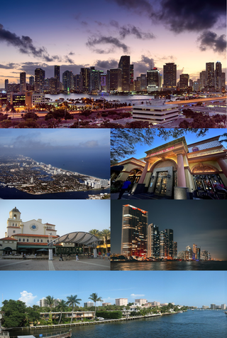
The Miami metropolitan area, also known as South Florida, SoFlo, SoFla, the Gold Coast, the Tri-County Area, or Greater Miami, and officially the Miami–Fort Lauderdale–West Palm Beach Metropolitan Statistical Area, is a coastal metropolitan area in southeastern Florida. It is the ninth-largest metropolitan statistical area (MSA) in the United States, the fifth-largest metropolitan area in the Southern United States, and the largest metropolitan area in Florida. With a population of 6.18 million, its population exceeds 31 of the nation's 50 states as of 2023. It comprises the three most populated counties in the state, Miami-Dade County, Broward County, and Palm Beach County, which rank as the first, second, and third-most populous counties in the state, respectively. Miami-Dade County, with 2,701,767 people in 2020, is the seventh-most populous county in the United States.

<span class="mw-page-title-main">Florida Gulf Coast University</span> Public university in Fort Myers, Florida, U.S.

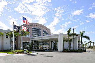
Florida Gulf Coast University (FGCU) is a public university in Lee County, Florida near Fort Myers. It is part of the State University System of Florida and is its second youngest member. The university was established on May 3, 1991, and is accredited by the Southern Association of Colleges and Schools (SACS). It offers 58 bachelor's degree programs, 25 master's degree programs, 6 doctoral degree programs, and 12 graduate certificates.

<span class="mw-page-title-main">Southwest Florida</span> Region in Florida

Southwest Florida is the region along the southwest Gulf coast of the U.S. state of Florida. The area is known for its beaches, subtropical landscape, and winter resort economy.

<span class="mw-page-title-main">Area code 239</span> Area code for southwestern Florida

Area code 239 is a telephone area code in the North American Numbering Plan (NANP) for a part of Southwestern Florida. The numbering plan area (NPA) includes Lee and Collier counties, small parts of Hendry and Charlotte counties and the Everglades National Park in Mainland Monroe County. The area code was activated for service on March 11, 2002, in an area code split in which the southern half of NPA 941, from North Fort Myers, was renumbered with 239. A permissive dialing period ended on March 10, 2003.

References

  1. 1 2 3 "Lighthouse Project - History: Bonita Springs began as town of Survey, evolved into city it is today". naplesnews.com.
  2. 1 2 3 "A Tale of Three Cities: Bonita Springs: Second Time's the Charm". www.yourobserver.com.
  3. "FLORIDA CITIES BY INCORPORATION YEAR WITH INCORPORATION & DISSOLUTION INFO" (PDF). www.flcities.com.
  4. "2020 U.S. Gazetteer Files". United States Census Bureau. Retrieved October 31, 2021.
  5. United States Census Bureau (December 29, 2022). "2020 Census Qualifying Urban Areas and Final Criteria Clarifications". Federal Register.
  6. "U.S. Census website". United States Census Bureau. Retrieved January 31, 2008.
  7. "US Board on Geographic Names". United States Geological Survey. October 25, 2007. Retrieved January 31, 2008.
  8. "Explore Census Data". data.census.gov. Retrieved September 29, 2022.
  9. "The History Of Bonita Springs". Bonita National Golf And Country Club. Retrieved May 15, 2024.
  10. "History - City of Bonita Springs". City of Bonita Springs. Retrieved May 15, 2024.
  11. "History of Bonita Springs". Bonita Springs Historical Society. Retrieved May 15, 2024.
  12. "History of Bonita Springs". Bonita Springs Historical Society. Retrieved May 15, 2024.
  13. "The History Of Bonita Springs". Bonita National Golf And Country Club. Retrieved May 15, 2024.
  14. "History - City of Bonita Springs". City of Bonita Springs. Retrieved May 15, 2024.
  15. "History of Bonita Springs". Bonita Springs Historical Society. Retrieved May 15, 2024.
  16. "History of Bonita Springs, Florida". Best Bonita Springs Vacation Rental. Retrieved May 15, 2024.
  17. "Bonita Springs, Florida". Advisory Council on Historic Preservation. Retrieved May 15, 2024.
  18. "History - City of Bonita Springs". City of Bonita Springs. Retrieved May 15, 2024.
  19. "History of Bonita Springs". Bonita Springs Historical Society. Retrieved May 15, 2024.
  20. "The History Of Bonita Springs". Bonita National Golf And Country Club. Retrieved May 15, 2024.
  21. "Bonita Springs, Florida". Advisory Council on Historic Preservation. Retrieved May 15, 2024.
  22. "The History Of Bonita Springs". Bonita National Golf And Country Club. Retrieved May 15, 2024.
  23. "CENSUS OF POPULATION AND HOUSING (1790-2000)". U.S. Census Bureau. Retrieved July 31, 2010.
  24. Census figures enumerated from 1970 to 1990 were prior to incorporation as Bonita Springs CDP .
  25. "P2 HISPANIC OR LATINO, AND NOT HISPANIC OR LATINO BY RACE - 2010: DEC Redistricting Data (PL 94-171) - Bonita Springs city, Florida". United States Census Bureau .
  26. "P2 HISPANIC OR LATINO, AND NOT HISPANIC OR LATINO BY RACE - 2020: DEC Redistricting Data (PL 94-171) - Bonita Springs city, Florida". United States Census Bureau .
  27. "S1101 HOUSEHOLDS AND FAMILIES - 2020: Bonita Springs city, Florida". United States Census Bureau .
  28. "S1101 HOUSEHOLDS AND FAMILIES - 2010: Bonita Springs city, Florida". United States Census Bureau .
  29. "Bonita Springs, Florida". Advisory Council on Historic Preservation. Retrieved May 15, 2024.
  30. "History of Bonita Springs". Bonita Springs Historical Society. Retrieved May 15, 2024.
  31. "History of Bonita Springs, Florida". Best Bonita Springs Vacation Rental. Retrieved May 15, 2024.
  32. "History - City of Bonita Springs". City of Bonita Springs. Retrieved May 15, 2024.
  33. "History of Bonita Springs, Florida". Best Bonita Springs Vacation Rental. Retrieved May 15, 2024.
  34. "Market Survey Schedule & Population Rankings" (PDF). Wargod.arbitron.com. Retrieved November 3, 2015.
  35. "Local Television Market Universe Estimates : Comparisons of 2012-13 and 2013-14 Market Ranks" (PDF). Nielsen.com. Retrieved November 3, 2015.
  36. "Bonita Springs TV 98 Government Access Channel". BTV98. City of Bonita Springs. Archived from the original on March 16, 2016. Retrieved January 3, 2019.
  37. Bender, Andrew (May 24, 2013). "America's Top 10 Beaches of 2013". Forbes.
  38. "DEP confirmation that Lover's Key lies in city limits" (PDF). Dep. state.fl.us. Retrieved November 3, 2015.
  39. "Everglades Wonder Gardens". Everglades Wonder Gardens. Retrieved May 15, 2024.

Sister cities

Notable people

References

  1. "City Council Mieeting Agenda" (PDF). www.cityofbonitasprings.org. July 5, 2000. Archived from the original (PDF) on December 28, 2018. Retrieved December 27, 2018.
  2. "Bonita Springs to become sister city with Isla Mujeres, Mexico". bonitasprings.floridaweekly.com. March 15, 2018. Retrieved December 27, 2018.
  3. "Glenn Steil obituary". Grand Rapids Press. May 11, 2010. Archived from the original on August 1, 2020.