Border irregularities of the United States

Last updated

Border irregularities of the United States, particularly panhandles and highway incursions into other jurisdictions, are shown here. Often they are a result of borders which do not conform to geological features such as changes in the course of a river that previously marked a border.

Contents

International

Canada

The Northwest Angle in Minnesota, bordering Manitoba, Ontario, and Lake of the Woods NORTHWEST Angle.png
The Northwest Angle in Minnesota, bordering Manitoba, Ontario, and Lake of the Woods

There are several exclaves between the United States and Canada, including the entire state of Alaska (though the state can still be accessed by sea from the United States, except the small settlement of Hyder which is only accessible by road from British Columbia). Other exclaves include Akwesasne, the Northwest Angle, Point Roberts, and Seaway Island.

The status of the waters around Nunez Rocks is disputed. Nunez Rocks is a low-tide elevation ("bare at half-tide" [1] ) area (LTE) that is south of a line known as the "A-B" Line, [2] which was defined in a 1903 arbitration decision on the Alaska–Canada boundary. [3] The court specified the initial boundary point (Point "A") at the northern end of Dixon Entrance [4] and Point "B" 72 nautical miles (83 mi; 133 km) to the east. [5] Canada relies on the "A-B" Line as rendering nearly all of Dixon Entrance as Canadian internal waters. The U.S. does not recognize the "A-B" Line as an official boundary, instead regarding it as allocating sovereignty over the land masses within the Dixon Entrance, [2] with Canada's land south of the line. The U.S. regards the waters as subject to international marine law, and in 1977 it defined an equidistant territorial sea throughout Dixon Entrance. [2] This territory, which surrounds Nunez Rocks, extends south of the "A-B" line for the most part. [2] The United States has not ratified the Law of the Sea Treaty, although it adheres to most of its principles as customary international law. Under the treaty, LTEs may be used as basepoints for a territorial sea, and the U.S. uses Nunez Rocks as a basepoint. As a non-signatory, however, there is nothing preventing the U.S. from claiming areas beyond the scope of the Law of the Sea Treaty. The fact remains that, for about half of each day, above-water territory that is Canadian is surrounded by sea territory that the U.S. has declared to be American.

Another disputed area is the Grey Zone, including Machias Seal Island, in the Gulf of Maine.

The Aroostook Valley Country Club is a golf course which straddles the Canada–US border, between the U.S. state of Maine and the Canadian province of New Brunswick. The club, located near Perth-Andover, New Brunswick and Fort Fairfield, Maine, has its course (except part of the tee area for the ninth hole, and possibly part of a sand trap on the first hole) and clubhouse on the Canadian side of the border and its parking lot and pro shop on the American side. [6]

East Richford Slide Road in the U.S. state of Vermont crosses into the Canadian province of Québec for a distance of approximately 330 feet (100 m) before returning to the United States. [7]

The Piney Pinecreek Border Airport runway straddles the Canada–U.S. border, between the U.S. state of Minnesota and the Canadian province of Manitoba. [8] When flying to this airport, travelers must inform customs officials at least one hour prior to landing.[ citation needed ]

Mexico

In Texas and Mexico, shifts in the course of the lower Rio Grande have created numerous bancos. Under the Boundary Treaty of 1970 and earlier treaties, the United States and Mexico have maintained the actual course of the river as the international boundary, but both must approve proposed changes. From 1989 to 2009, there were 128 locations where the river changed course, causing land that had been on one side of the river to then occupy the opposite bank. Until the boundary is officially changed, there are 60 small exclaves of the state of Texas now lying on the southern side of the river, as well as 68 such exclaves of Mexico on the northern side of the river.

Russia

The legal status of the U.S.-Russian border is unclear. The United States Senate ratified a treaty setting the boundary with the Soviet Union in 1991. However, shortly after, the Soviet Union collapsed, and the Russian parliament never voted on the treaty.

States and territories

Separated by water

Separated by the Mississippi River

These border irregularities were caused by changes in the Mississippi River during the 1812 New Madrid earthquake or other river changes:

  • Over a period of about 24 hours on 7 March 1876, the Mississippi River abandoned its former channel that defined the Tennessee-Arkansas border, and established a new channel east of Tennessee's Reverie and Corona, located in Tipton County north-northwest of Memphis. [10]

Other irregularities involving the Mississippi River:

  • Arkansas has territory at 35°39′N89°52′W / 35.65°N 89.87°W / 35.65; -89.87 across the Mississippi River on the northwest edge of Tennessee's Fort Pillow State Park, north of the Corona/Reverie, Tennessee irregularity (mentioned in the previous section).
  • Illinois's Kaskaskia, Missouri's Grand Tower Island and other Illinois and Missouri territory on each other's side of the Mississippi River.
Kentucky Bend and surrounding area
.mw-parser-output .legend{page-break-inside:avoid;break-inside:avoid-column}.mw-parser-output .legend-color{display:inline-block;min-width:1.25em;height:1.25em;line-height:1.25;margin:1px 0;text-align:center;border:1px solid black;background-color:transparent;color:black}.mw-parser-output .legend-text{}
Missouri (MO)
Tennessee (TN)
Kentucky (KY) Kentucky Bend map.png
Kentucky Bend and surrounding area
   Missouri (MO)
   Tennessee (TN)
   Kentucky (KY)

Other irregularities

State border of Ellis Island after New Jersey vs. New York, 1998. Green is the area of the original natural island, part of New York City, New York, while the man-made rest of the island is part of Jersey City, New Jersey Ellis Island 1890 - 1935 NPS map.jpg
State border of Ellis Island after New Jersey vs. New York, 1998. Green is the area of the original natural island, part of New York City, New York, while the man-made rest of the island is part of Jersey City, New Jersey

Related Research Articles

<span class="mw-page-title-main">Fulton County, Kentucky</span> County in Kentucky, United States

Fulton County is the westernmost county in the U.S. state of Kentucky, with the Mississippi River forming its western boundary. As of the 2020 census, the population was 6,515. Its county seat is Hickman and its largest city is Fulton. The county was formed in 1845 from Hickman County, Kentucky and named for Robert Fulton, the inventor of the steamboat.

<span class="mw-page-title-main">Mississippi County, Arkansas</span> County in Arkansas, United States

Mississippi County is the easternmost county in the U.S. state of Arkansas. As of the 2020 census, the population was 40,685. There are two county seats, Blytheville and Osceola. The county was formed on November 1, 1833, and named for the Mississippi River which borders the county to the east. Mississippi County is part of the First Congressional District in Arkansas.

<span class="mw-page-title-main">Craighead County, Arkansas</span> County in Arkansas, United States

Craighead County is a county located in the U.S. state of Arkansas. As of the 2020 census, the population was 111,231. The county has two county seats — Jonesboro and Lake City. Craighead County is Arkansas's 58th county, formed on February 19, 1859, and named for state Senator Thomas Craighead. It is one of several dry counties within the state of Arkansas, in which the sale of alcoholic beverages is largely prohibited.

<span class="mw-page-title-main">Adams–Onís Treaty</span> Treaty ceding Spanish Florida to the U.S. (1819)

The Adams–Onís Treaty of 1819, also known as the Transcontinental Treaty, the Spanish Cession, the Florida Purchase Treaty, or the Florida Treaty, was a treaty between the United States and Spain in 1819 that ceded Florida to the U.S. and defined the boundary between the U.S. and Mexico. It settled a standing border dispute between the two countries and was considered a triumph of American diplomacy. It came during the successful Latin American wars of independence against Spain.

<span class="mw-page-title-main">Canada–United States border</span> International border

The Canada–United States border is the longest international border in the world. The terrestrial boundary is 8,891 km (5,525 mi) long. The land border has two sections: Canada's border with the contiguous United States to its south, and with the U.S. state of Alaska to its west. The bi-national International Boundary Commission deals with matters relating to marking and maintaining the boundary, and the International Joint Commission deals with issues concerning boundary waters. The agencies currently responsible for facilitating legal passage through the international boundary are the Canada Border Services Agency (CBSA) and U.S. Customs and Border Protection (CBP).

<span class="mw-page-title-main">Mississippi Alluvial Plain</span> Plain created by the Mississippi River in the United States

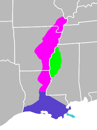
The Mississippi River Alluvial Plain is an alluvial plain created by the Mississippi River on which lie parts of seven U.S. states, from southern Louisiana to southern Illinois.

<span class="mw-page-title-main">Kentucky Bend</span> Peninsula in Fulton County, Kentucky

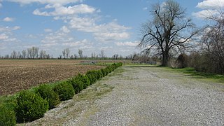
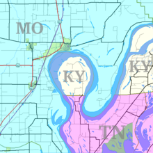
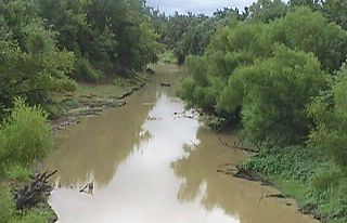
The Kentucky Bend, variously called the New Madrid Bend, Madrid Bend, Bessie Bend, or Bubbleland, is an exclave of Fulton County, Kentucky, encircled by the states of Tennessee and Missouri. It is a portion of a peninsula defined by an oxbow loop meander of the Mississippi River, and its inclusion in the state of Kentucky stems from uncertainties of the course of the Mississippi River when the boundary between Tennessee and Kentucky was established.

<span class="mw-page-title-main">Honey War</span> 1839 territorial dispute

<span class="mw-page-title-main">United States National Register of Historic Places listings</span> Register for landmarks in the United States

The National Register of Historic Places in the United States is a register including buildings, sites, structures, districts, and objects. The Register automatically includes all National Historic Landmarks as well as all historic areas administered by the U.S. National Park Service. Since its introduction in 1966, more than 90,000 separate listings have been added to the register.

<span class="mw-page-title-main">Poteau River</span> River in Oklahoma, United States

The Poteau River is a 141-mile (227 km) long river located in the U.S. states of Arkansas and Oklahoma. It is the only river in Oklahoma that flows north and is the seventh largest river in the state. It is a tributary of the Arkansas River, which itself is a tributary of the Mississippi River. During the Indian Territory period prior to Oklahoma's statehood (1838-1906), the stream served as the boundary between Skullyville County and Sugar Loaf County, two of the counties making up the Moshulatubbee District of the Choctaw Nation.

<span class="mw-page-title-main">Enclave and exclave</span> Territory (or part of one) entirely surrounded by the territory of one other state

An enclave is a territory that is entirely surrounded by the territory of one other state or entity. Enclaves may also exist within territorial waters. Enclave is sometimes used improperly to denote a territory that is only partly surrounded by another state. Vatican City and San Marino, both enclaved by Italy, and Lesotho, enclaved by South Africa, are completely enclaved sovereign states.

<span class="mw-page-title-main">Territorial evolution of the United States</span> Changes and expansion of the territory of the United States

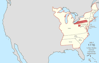
The United States of America was formed after thirteen British colonies in North America declared independence from the British Empire on July 4, 1776. In the Lee Resolution, passed by the Second Continental Congress two days prior, the colonies resolved that they were free and independent states. The union was formalized in the Articles of Confederation, which came into force on March 1, 1781, after being ratified by all 13 states. Their independence was recognized by Great Britain in the Treaty of Paris of 1783, which concluded the American Revolutionary War. This effectively doubled the size of the colonies, now able to stretch west past the Proclamation Line to the Mississippi River. This land was organized into territories and then states, though there remained some conflict with the sea-to-sea grants claimed by some of the original colonies. In time, these grants were ceded to the federal government.

<span class="mw-page-title-main">Parallel 36°30′ north</span> Historically significant latitude

The parallel 36°30′ north is a circle of latitude that is 36 and one-half degrees north of the equator of the Earth. This parallel of latitude is particularly significant in the history of the United States as the line of the Missouri Compromise, which was used to divide the prospective slave and free states west of the Mississippi River, with the exception of Missouri, which is mostly north of this parallel.

Corona is an unincorporated community in Tipton County, Tennessee, United States.

Artificial Island is a U.S. island located along the eastern shore of the Delaware River, mostly in southwestern New Jersey with a tiny portion inside Delaware's boundaries. It is part of both Lower Alloways Creek Township, Salem County, New Jersey and New Castle County, Delaware. The island is separated from mainland New Jersey by Alloway Creek and Hope Creek. It is called "artificial" since portions of the island are composed of land reclaimed from Delaware Bay.

References

  1. U.S. National Geodetic Survey. "NOAA Shoreline Data Explorer" . Retrieved 2015-04-10.
  2. 1 2 3 4 Gray, David H. (Autumn 1997). "Canada's Unresolved Maritime Boundaries" (PDF). IBRU Boundary and Security Bulletin. p. 61. Retrieved 2015-03-21.
  3. "International Boundary Commission definition of the Canada/US boundary in the NAD83 CSRS reference frame". Archived from the original on 2021-08-01. Retrieved 2015-03-21.
  4. White, James (1914). Boundary Disputes and Treaties. Toronto: Glasgow, Brook & Company. pp.  936–958.
  5. Davidson, George (1903). The Alaska Boundary. San Francisco: Alaska Packers Association. pp.  79–81, 129–134, 177–179, 229.
  6. "Chapter 1: Eastern Maine". United Divide: A Linear Portrait of the USA/Canada Border. The Center for Land Use Interpretation. Winter 2015. Archived from the original on 2018-12-10. Retrieved 2018-10-01.
  7. Google Maps
  8. Google Maps
  9. Lewis and Clark and Julia Butler Hansen National Wildlife Refuges Draft CCP/EIS Chapter 2. Alternatives, Goals, Objectives, and Strategies (PDF). Washington, DC: United States Fish and Wildlife Service. pp. 2–27. Retrieved 2016-04-20.
  10. "Tipton". Tennessee History for Kids. Nashville, Tennessee. 2010-01-18. Archived from the original on 2010-07-06. Retrieved 2010-04-20.
  11. .Whong, Christopher M. (2000-12-11). "The Boundary Disputes of Colonial Maryland". Baltimore, Maryland . Retrieved 2010-04-20.
  12. "A little piece of Delaware is actually hidden in N.J. How did that happen?". 17 February 2019.