Bosso, Niger

Last updated
Bosso
Commune and village
Life goes on in Bosso 19 April 2017 - Prefecture.png
Bosso
Niger location map.svg
Red pog.svg
Bosso
Location in Niger
Coordinates: 13°41′49″N13°18′37″E / 13.6969°N 13.3103°E / 13.6969; 13.3103
CountryFlag of Niger.svg  Niger
Region Diffa Region
Department Diffa Department
Elevation
909 ft (277 m)
Population
 (2012)
  Total65.022
Time zone UTC+1 (WAT)

Bosso is a village and rural commune in the southeastern part of Niger. [1] As of 2011, the commune had a total population of 52,177 people. [2] It lies on the Nigerian border.

In June 2013, between 5,000 and 10,000 refugees arrived here, fleeing fighting between Boko Haram and the Nigerian Armed Forces in Borno State of Nigeria. Most blamed the military for the excessive violence and human rights violations. [3]

Climate

Köppen-Geiger climate classification system classifies its climate as hot desert (BWh).

Climate data for Bosso, Niger
MonthJanFebMarAprMayJunJulAugSepOctNovDecYear
Mean daily maximum °C (°F)29.4
(84.9)
32.4
(90.3)
36.2
(97.2)
38.8
(101.8)
39.5
(103.1)
38.2
(100.8)
35
(95)
33.1
(91.6)
35.1
(95.2)
36.5
(97.7)
33.4
(92.1)
30.1
(86.2)
34.8
(94.7)
Daily mean °C (°F)21
(70)
23.5
(74.3)
27.6
(81.7)
30.5
(86.9)
31.8
(89.2)
31.3
(88.3)
29.3
(84.7)
27.8
(82.0)
28.8
(83.8)
28.6
(83.5)
25
(77)
21.6
(70.9)
27.2
(81.0)
Mean daily minimum °C (°F)12.7
(54.9)
14.7
(58.5)
19.1
(66.4)
22.3
(72.1)
24.2
(75.6)
24.4
(75.9)
23.7
(74.7)
22.6
(72.7)
22.6
(72.7)
20.8
(69.4)
16.6
(61.9)
13.1
(55.6)
19.7
(67.5)
Average precipitation mm (inches)0
(0)
0
(0)
0
(0)
1
(0.0)
6
(0.2)
15
(0.6)
70
(2.8)
119
(4.7)
30
(1.2)
4
(0.2)
0
(0)
0
(0)
245
(9.7)
Source: Climate-Data.org (altitude: 287m) [4]

Related Research Articles

<span class="mw-page-title-main">Geography of Niger</span> Geographic feature of Niger

Niger is a landlocked nation in West Africa located along the border between the Sahara and Sub-Saharan regions. Its geographic coordinates are longitude 16°N and latitude 8°E

Diffa is a city and Urban Commune in the extreme southeast of Niger, near the border with Nigeria. It is the administrative seat of both Diffa Region, and the smaller Diffa Department. As of 2012, the commune had a total population of 56,437 people.

<span class="mw-page-title-main">Diffa Region</span> Region of Niger

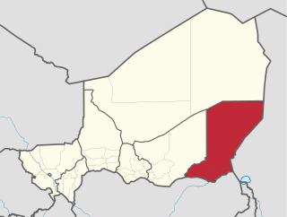
Diffa is one of the seven Regions of Niger, located in the southeast of the country. The capital of the region is Diffa.

<span class="mw-page-title-main">Dosso Region</span> Region of Niger

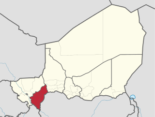
Dosso is one of the eight Regions of Niger. The region has an area of 31,002 square kilometres (11,970 sq mi), with a population of 2,754,500 as of 2020.

<span class="mw-page-title-main">Dakoro</span> Commune in Maradi, Niger

Dakoro is a town and commune located in the Maradi Region of Niger. As of 2012, it had a population of 71,201. It is the capital of the Dakoro Department.

<span class="mw-page-title-main">Kénadsa</span> Commune and town in Béchar Province, Algeria

Kénadsa is a town and commune in the Sahara Desert of south-western Algeria, and is the capital of Kénadsa District, Béchar Province. As of 2008, Kénadsa had a population of 13,492, up from 11,667 in 1998, and an annual growth rate of 1.5%. The commune covers an area of 2,770 square kilometres (1,070 sq mi).

<span class="mw-page-title-main">Aguie Department</span> Department in Maradi Region, Niger

Aguie is a department of the Maradi Region in Niger. Its capital lies at the city of Aguie.

Magaria is a town and urban commune in the magaria bande of the Zinder Region of Niger.

Tchirozerine is a town and urban commune in Niger. As of 2012, the commune's population was 63,503.

Abala, Niger is a village and rural commune in Niger.

Garhanga is a village and rural commune in Niger. It is located in the Keita Department of the Tahoua region. As of 2012, it has a population of 69,712.

<span class="mw-page-title-main">Harikanassou</span> Commune and village in Dosso, Niger

Harikanassou is a large village and rural commune in the Boboye Department of the Dosso Region of southwest Niger, 90.7 kilometres (56.4 mi) by road southeast of the capital of Niamey. At the time of the 2012 census, the rural community had 23,567 residents living in 3,340 households. Onion cultivation is a chief source of income for many, along with the cultivation of lettuce, beans, squashes, and tomatoes.

Sanam is a village and rural commune in Niger.

Tabelot is a village and rural commune in central Niger. As of 2011, the commune had a total population of 32,431 people.

Tamaske is a city and rural commune in Niger. It is located in the Keita Department, in the Tahoua Region.

<span class="mw-page-title-main">Tassara</span> Commune and village in Niger

Tassara is a village and rural commune in Niger.

Tondikandia is a rural commune in Filingué Department, Tillabéri Region, Niger. Its chief place and administrative center is the town of Damana.

Toumour is a village and rural commune in Niger located near the Niger–Nigeria border. As of 2012, the commune had a total population of 11,713 people.

Yaouri is a village and rural commune in Matameye Department in Niger.

<span class="mw-page-title-main">2015 Niger raid</span> ISIL raid on two Nigerien towns

The 2015 Niger raid was an unsuccessful assault on the Nigerien towns Bosso and Diffa, perpetrated by Boko Haram. The incident occurred on 6 February 2015, marking the first major Boko Haram incursion into Niger.

References

  1. Loi n° 2002-014 du 11 JUIN 2002 portant création des communes et fixant le nom de leurs chefs-lieux [ permanent dead link ]. Includes list of 213 communes rurales and seats, 52 Communes urbaines and seats
  2. "Annuaires_Statistiques" (PDF). Institut National de la Statistique . Retrieved 2 May 2013.
  3. Nossiter, Adam (5 June 2013). "In Nigeria, 'Killing People Without Asking Who They Are'". The New York Times . Retrieved 6 June 2013.
  4. "Climate: Bosso - Climate graph, Temperature graph, Climate table". Climate-Data.org. Retrieved 2014-02-20.

13°41′49″N13°18′37″E / 13.6969°N 13.3103°E / 13.6969; 13.3103