
Ghana is a West African country in Africa, along the Gulf of Guinea.
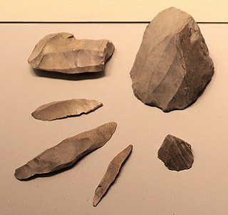
A microlith is a small stone tool usually made of flint or chert and typically a centimetre or so in length and half a centimetre wide. They were made by humans from around 35,000 to 3,000 years ago, across Europe, Africa, Asia and Australia. The microliths were used in spear points and arrowheads.
The 10th millennium BC spanned the years 10,000 BC to 9001 BC. It marks the beginning of the transition from the Palaeolithic to the Neolithic via the interim Mesolithic and Epipaleolithic periods, which together form the first part of the Holocene epoch that is generally believed to have begun c. 9700 BC and is the current geological epoch. It is impossible to precisely date events that happened around the time of this millennium, and all dates mentioned here are estimates mostly based on geological analysis, anthropological analysis, and radiometric dating.

Kintampo complex is the period in prehistory that saw the transition to sedentism in West Africa, specifically in the Bono East region of Ghana and parts of eastern Côte d'Ivoire that began sometime between 2500-1400 BCE. Besides being a classic example of early forest dwellers in West Africa, Kintampo is significant because there is evidence of a drastic change in food production techniques due to the transition from nomadic hunter-gather lifestyles to life in stationary settlements. This change is known as sedentism and is typical of societies who have access to, or are developing systems of agriculture. Ceramic sculptures of humans and animals indicate that the Kintampo settlements were inhabited by practitioners of both pastoralism and horticulture.
Kwahu refers to an area and group of people that live in Ghana and are part of the Twi-speaking Akan group. The area has been dubbed Asaase Aban, or the Natural Fortress, in view of its position as the highest habitable elevation in the country. Kwahu lies in the Eastern Region of Ghana, on the west shore of Lake Volta. The Kwahus share the Eastern Region with their fellow Akans: the Akyem and Akuapem, as well as the Adangbe-Krobos. A significant migrant population from the Northern and Volta Regions and some indigenous Guans from the bordering Oti and Brong East Regions live in the Afram Plains area. They work as traders, farm-hands, fisherfolk, and caretakers in the fertile waterfront 'melting pot'.

The Tsodilo Hills are a UNESCO World Heritage Site (WHS), consisting of rock art, rock shelters, depressions, and caves in southern Africa. It gained its WHS listing in 2001 because of its unique religious and spiritual significance to local peoples, as well as its unique record of human settlement over many millennia. UNESCO estimates there are over 4500 rock paintings at the site. The site consists of a few main hills known as the Child Hill, Female Hill, and Male Hill.
Mumba Cave, located near the highly alkaline Lake Eyasi in Karatu District, Arusha Region, Tanzania. The cave is a rich archaeological site noted for deposits spanning the transition between the Middle Stone Age and Late Stone Age in Eastern Africa. The transitional nature of the site has been attributed to the large presence of its large assemblage of ostrich eggshell beads and more importantly, the abundance of microlith technology. Because these type artifacts were found within the site it has led archaeologists to believe that the site could provide insight into the origins of modern human behavior. The cave was originally tested by Ludwig Kohl-Larsen and his wife Margit in their 1934 to 1936 expedition. They found abundant artifacts, rock art, and burials. However, only brief descriptions of these findings were ever published. That being said, work of the Kohl-Larsens has been seen as very accomplished due to their attention to detail, especially when one considers that neither was versed in proper archaeological techniques at the time of excavation. The site has since been reexamined in an effort to reanalyze and complement the work that has already been done, but the ramifications of improper excavations of the past are still being felt today, specifically in the unreliable collection of C-14 data and confusing stratigraphy.
Balangoda Man refers to hominins from Sri Lanka's late Quaternary period. The term was initially coined to refer to anatomically modern Homo sapiens from sites near Balangoda that were responsible for the island's Mesolithic 'Balangoda Culture'. The earliest evidence of Balangoda Man from archaeological sequences at caves and other sites dates back to 38,000 BP, and from excavated skeletal remains to 30,000 BP, which is also the earliest reliably dated record of anatomically modern humans in South Asia. Cultural remains discovered alongside the skeletal fragments include geometric microliths dating to 28,500 BP, which together with some sites in Africa is the earliest record of such stone tools.

Franktown Cave is located 25 miles south of Denver, Colorado on the north edge of the Palmer Divide. It is the largest rock shelter documented on the Palmer Divide, which contains artifacts from many prehistoric cultures. Prehistoric hunter-gatherers occupied Franktown Cave intermittently for 8000 years beginning about 6400 B.C. The site held remarkable lithic and ceramic artifacts, but it is better known for its perishable artifacts, including animal hides, wood, fiber and corn. Material goods were produced for their comfort, task-simplification and religious celebration. There is evidence of the site being a campsite or dwelling as recent as AD 1725.
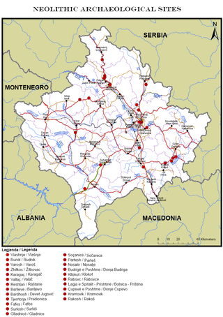
This is a description of Neolithic sites in Kosovo. The warm, humid climate of the Holocene which came soon after the ice melting of the last glacial period brought changes in nature which were reflected in humans, flora and fauna. This climatic stabilization influenced human life and activities; human society is characterized by changes in community organization and the establishment of permanent settlements in dry places, near riverbanks and on fertile plateaus.
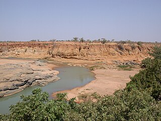
Ounjougou is the name of a lieu-dit found in the middle of an important complex of archaeological sites in the Upper Yamé Valley on the Bandiagara Plateau, in Dogon Country, Mali. The Ounjougou archaeological complex consists of over a hundred sites. The analysis of many layers rich in archaeological and botanical remains has enabled establishment of a major chronological, cultural and environmental sequence crucial to understand settlement patterns in the Inland Niger Delta and West Africa. Ounjougou has yielded the earliest pottery found in Africa, and is believed to be one of the earliest regions in which the independent development of pottery occurred.
Wadi Debayan is the oldest Neolithic archaeological site in Qatar. It was occupied over a stretch of 3000 years before being abandoned in the Bronze Age. Remnants of marine life, plant material and structural components were among the artifacts excavated. Fragments of pottery originating from the early Ubaid period were also recovered.
The Kalemba Rockshelter is an archaeology site located in eastern Zambia, at coordinates 14°7 S and 32°3 E. Local tradition recalls the use of the rock shelter as a refuge during the time of Ngoni raiding in the 19th century. The site is known for various rock paintings as well as advanced microlithic use.
Taforalt or Grotte des Pigeons is a cave in the province of Berkane, Aït Iznasen region, Morocco, possibly the oldest cemetery in North Africa. It contained at least 34 Iberomaurusian adolescent and adult human skeletons, as well as younger ones, from the Upper Palaeolithic between 15,100 and 14,000 calendar years ago. There is archaeological evidence for Iberomaurusian occupation at the site between 23,200 and 12,600 calendar years ago, as well as evidence for Aterian occupation as old as 85,000 years.
Trialetian is the name for an Upper Paleolithic-Epipaleolithic stone tool industry from the South Caucasus. It is tentatively dated to the period between 16,000 / 13,000 BP and 8,000 BP.

Sang-i Chakmak is a Neolithic archaeological site located about 1 km (0.62 mi) north of the village of Bastam in the northern Semnan Province of Iran, on the southeastern flank of the Elburs Mountains. The site represents quite well the transition from the aceramic Neolithic phase in the general area; this was taking place during the 7th millennium BC.
Kharaysin is a Pre-Pottery Neolithic site (PPN) located in the village of Quneya, at the Zarqa River valley, Jordan. This site was discovered in 1984 by Hanbury-Tenison and colleagues during the Jerash Region Survey. The site was allocated to the Pre-Pottery Neolithic B because of the analysis of archaeological artefacts recovered on the surface.

The Mlambalasi Rock Shelter is a historic site located in Iringa District of Iringa Region in southern Tanzania, 50 km away from Iringa City. Excavations in 2006 and 2010 by the Iringa Region Archaeological Project uncovered artifactual deposits from the Later Stone Age (LSA), the Iron Age, and the historic periods, as well as external artifacts from the Middle Stone Age (MSA). Direct dating on Achatina shell and ostrich eggshell beads indicates that the oldest human burials at Mlambalasi are from the terminal Pleistocene. Mlambalasi is characterized by interment LSA and Iron Age periods, as well as by cycles of use and abandonment.
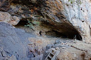
Ghana was initially referred to as the Gold Coast. After attaining independence, the country's first sovereign government named the state after the Ghana Empire in modern Mauritania and Mali. Gold Coast was initially inhabited by different states, empires and ethnic groups before its colonization by the British Empire. The earliest known physical remains of the earliest man in Ghana were first discovered by archaeologists in a rock shelter at Kintampo during the 1960s. The remains were dated to be 5000 years old and it marked the period of transition to sedentism in Ghana. Early Ghanaians used Acheulean stone tools as hunter gatherers during the Early stone age. These stone tools evolved throughout the Middle and Late Stone Ages, during which some early Ghanaians inhabited caves.
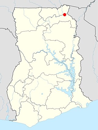
The Birimi site is an archaeological site in Northern Ghana, Africa, between the towns of Gambaga and Nalerigu. It’s most notable for its history of occupation during the Middle Stone Age, Late Stone Age and Iron Age. It’s connection to the Kintampo Complex makes this a notable archaeological site.

