
The Calder Valley line is a railway route in Northern England between the cities of Leeds and Manchester as well as the seaside resort of Blackpool. It is the slower of the two main rail routes between Leeds and Manchester, and the northernmost of the three main trans-Pennine routes.

The Huddersfield line is the main railway line between the English cities of Leeds and Manchester via Huddersfield. It is one of the busiest MetroTrain lines. The route travels south-south west from Leeds through Dewsbury. After a short westward stretch through Mirfield, it continues south west through Huddersfield, using the Colne Valley to its headwaters. The long Standedge Tunnel just after Marsden crosses under the watershed and the majority of the run down to Manchester is in the Tame valley. From Manchester, some services continue to Manchester Airport and others to Liverpool.

The Manchester and Leeds Railway was a British railway company that built a line from Manchester to Normanton where it made a junction with the North Midland Railway, over which it relied on running powers to access Leeds. The line followed the valley of the River Calder for much of the way, making for easier gradients but by-passing many important manufacturing towns. Crossing the watershed between Lancashire and Yorkshire required a long tunnel. The line opened throughout in 1841.
New Pudsey railway station is in Farsley, West Yorkshire, England, on the Calder Valley line from Leeds to Bradford Interchange, Halifax, Huddersfield, Manchester Victoria, and Blackpool North. Lying 5.75 miles (9.25 km) west of Leeds, it serves as a commuter station for the western edge of the Leeds conurbation.
Bramley railway station serves the suburb of Bramley, Leeds, England. It lies on the Calder Valley line 4 miles (6 km) west from Leeds.

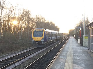
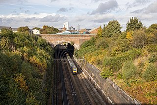
Mirfield railway station serves the town of Mirfield in West Yorkshire, England. It lies on the Huddersfield Line managed by Northern and by Grand Central and recently it has been served by TransPennine Express. The station is 4 miles (6 km) north east from Huddersfield.

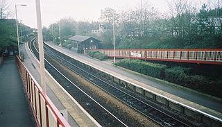
Sowerby Bridge railway station serves the town of Sowerby Bridge in West Yorkshire, England. It lies on the Caldervale Line 4.5 miles (7 km) west of Halifax and 21 miles (34 km) west of Leeds.
The Queensbury lines was the name given to a number of railway lines in West Yorkshire, England, that linked Bradford, Halifax and Keighley via Queensbury. All the lines were either solely owned by the Great Northern Railway (GNR) or jointly by the GNR and the Lancashire and Yorkshire Railway (L&YR). The terrain was extremely challenging for railway construction, and the lines were very expensive to build. The lines were
Low Moor railway station serves the villages of Low Moor and Oakenshaw in the south of Bradford, West Yorkshire, England. The station is situated on the Calder Valley Line between Bradford Interchange and Halifax.

Queensbury railway station was a station on the Queensbury lines serving the village of Queensbury, West Yorkshire, England. The station was unusual due to its triangular shape, and at its opening the only other examples of this arrangement were Ambergate station in Derbyshire and Earlestown in Lancashire; since then Shipley station, also in West Yorkshire, has gained platforms on all three sides. Of the stations on the Queensbury lines, this was the most ambitious.
Bowling railway station is a closed station in the city of Bradford, West Yorkshire, England. It was on the line connecting the Bradford Exchange - Low Moor line of the Lancashire and Yorkshire Railway with the line of the Great Northern Railway (GNR) at Laisterdyke. It was opened by the GNR on 1 August 1854 and closed to passengers on 1 February 1895. The line remained open to freight until 4 May 1964. No trace remains of the station which was located northeast of the bridge crossing Wakefield Road.

St Dunstans railway station is a closed station in the city of Bradford, West Yorkshire, England. The station was the location of a three-way junction with platforms on two of the lines.

Bradford Exchange railway station served the city of Bradford, West Riding of Yorkshire, England, from 1850 to 1973, before being replaced by a smaller, new-build station, which was later called Bradford Interchange. Railway lines from Halifax, Queensbury, Wakefield and Leeds met south of the city centre with services terminating in the station. In the British Rail era, many services did not terminate at Exchange station but became through services which reversed in the station to carry on their journey. Exchange station was originally opened in 1850 by the Lancashire & Yorkshire Railway (L&YR) as Drake Street, becoming Exchange in April 1867 with the arrival of services from the Great Northern Railway (GNR).

Morley Tunnel is a railway tunnel in West Yorkshire, England, situated between Morley and Batley railway stations on the Huddersfield line. From its northern end, it extends 3,369 yards (3,081 m), passing beneath Morley town centre, to its southern end.

Lees Moor Tunnel is an abandoned tunnel on the former Great Northern Railway line between Queensbury and Keighley in West Yorkshire, England. The former dual track tunnel is just north of the village of Cullingworth in West Yorkshire and when built was 1,533 yards (1,402 m) long. Due to the pitch black inside and the squealing of the wheels on the 1 in 50 radius curve, drivers nicknamed it the 'Hell Hole'. After closure to passengers, the tunnel was used in experiments involving the effects of smoke inhalation and cancer.

The Leeds, Bradford and Halifax Junction Railway (LB&HJR) was an English railway company. It built a line between Bradford and Leeds, and had running powers over the Lancashire and Yorkshire Railway to Halifax. It opened its main line in 1854 and later built a number of branch lines.
Heckmondwike Spen was a railway station opened by the London & North Western Railway (LNWR) in Heckmondwike, West Yorkshire, England. The station was one of two in the town of Heckmondwike, the other being Heckmondwike Central which was opened by the Lancashire & Yorkshire Railway (L&Y). Both stations have been closed and the lines they served have closed too although the formations that they occupied have both been converted into greenways.

The Spen Valley Line was a railway that connected Mirfield with Low Moor through the Spen Valley in West Yorkshire, England. Opened up by the Lancashire and Yorkshire Railway in 1847, with full opening to Low Moor in 1848, the line served a busy industrial and textile area and allowed a connection for trains between Huddersfield and Bradford. The line was absorbed by the London & North Western Railway, the London Midland and Scottish Railway (LMS) and British Railways on Nationalisation. A separate link between Heckmondwike Central and Thornhill that opened later and was known as the Ravensthorpe Branch, allowed through running to Wakefield and beyond. The line was closed down to passengers in 1965 with freight continuing sporadically until 1981. A Spur onto the former Leeds New Line from the Ravensthorpe Branch kept the very southern end open until the late 1980s. The majority of the route is now the Spen Valley Greenway cycle path.
Richmond Hill Tunnel is a railway tunnel to the east of Leeds city centre, in West Yorkshire, England. The tunnel is known to be the first in the world specifically designed to carry passengers to be worked by steam trains rather than a stationary engine. One of the innovative methods employed to reassure passengers going through the lightless tunnel, was to place copper sheets underneath the air shafts which were intended to reflect the light around the tunnel. The original Richmond Hill Tunnel was 700 yards (640 m) long, but in 1894, it was widened into a cutting with a shorter tunnel, which is the existing structure in use today. The present Richmond Hill Tunnel is 118 yards (108 m) long, and is part of the longer Marsh Lane Cutting, which connects the eastward entrance and exit into Leeds railway station to the lines going towards Selby and York.
Gascoigne Wood Junction railway station was a railway station near Sherburn-in-Elmet in North Yorkshire, England. It was originally opened as a junction station, enabling transfers for passengers between trains. It was later a private halt station for the staff who worked at the Gascoigne Wood marshalling yard. It opened in 1839, and was closed, renamed and re-opened several times before closing completely in 1959. The station was 14 miles (23 km) from Leeds New Station, and 6 miles (9.7 km) from Selby.
