Boxworth

Last updated

Boxworth
Boxworth, St Peter - geograph.org.uk - 3275.jpg
St Peter's Church
Cambridgeshire UK location map.svg
Red pog.svg
Boxworth
Location within Cambridgeshire
Population218 (2011 Census) [1]
OS grid reference TL348642
District
Shire county
Region
Country England
Sovereign state United Kingdom
Post town CAMBRIDGE
Postcode district CB23
Dialling code 01954
Police Cambridgeshire
Fire Cambridgeshire
Ambulance East of England
UK Parliament
List of places
UK
England
Cambridgeshire
52°15′34″N0°01′35″W / 52.25946°N 0.02637°W / 52.25946; -0.02637 Coordinates: 52°15′34″N0°01′35″W / 52.25946°N 0.02637°W / 52.25946; -0.02637

Boxworth is a village in South Cambridgeshire, situated about eight miles to the north-west of Cambridge. [2] It falls under the Papworth Everard and Caxton ward and lies within the diocese of Ely. The village covers an area of 1,053 ha. (2,602 a.) [3] Boxworth is a relatively small village, with around 100 houses.

Contents

History

The place-name 'Boxworth' is first attested in the Domesday Book of 1086, where it appears as Bochesuuorde. It appears as Bukeswrth in 1228 in the Feet of Fines. The name means 'Bucc's enclosure or homestead'. [4]

In the 1664 Hearth Tax, a large house belonging to a gentleman, Mr Killingworth, accounted for eight hearths at Boxworth. [5]

Boxworth's population, once considerable, shrank severely after the Middle Ages before recovering to reach a peak of c350 in the mid-19th century.

In 1870–72, John Marius Wilson's Imperial Gazetteer of England and Wales described Boxworth like this: "BOXWORTH, a parish in the district of St. Ives and county of Cambridge; 3 miles WSW of Long-Stanton r. station, and 5 SSE of St. Ives. Post Town, Long-Stanton, under Cambridge. Acres, 2,521. Real property, £2,946 Pop., 347. Houses, 64. The property is divided among a few. The living is a rectory in the diocese of Ely. Value, £459.* Patron, G. Thornhill, Esq. The church has a monument of Sanderson, the blind professor of mathematics; and is good."

Village life

Boxworth today has one public house, the Golden Ball. The pub dates from at least the 1760s, but took its current name in 1820.

Church

Recorded from the mid-12th century, when relics of St. 'Inicius' were said to be deposited there, the church of St Peter is an ancient edifice of flint and stone in the Decorated style, consisting of a chancel, a nave of four bays, a south aisle, north and south porches and a lofty, embattled tower containing a clock and one bell: in the church is a monument to Nicholas Saunderson LLD, FRS, the celebrated blind professor of mathematics at the University of Cambridge, who died on 19 April 1739. Poet Mary Rolls' husband Henry Rolls served his curacy at Boxworth from 1813 to 1816. [6] The church was thoroughly restored in 1868–9, and provides seating for 150 worshippers. There are some pictures and a description of the church at the Cambridgeshire Churches website. [7] There is a more comprehensive history at www.british-history.ac.uk. [8]

The grave of the Rev. Arnold Kirke Smith, who was vicar for 38 years until his death in 1927; he had in his early years been a notable footballer Memorial for Revd Arnold Kirke Smith - geograph.org.uk - 388926.jpg
The grave of the Rev. Arnold Kirke Smith, who was vicar for 38 years until his death in 1927; he had in his early years been a notable footballer

Road

The Road is designed to be a small access road to the rural outlying villages of Cambridge surrounding it, including Elsworth, Conington and Knapwell, and is usually quiet. However, as the village lies between two major roads – the A428 and the notorious A14 (previously A604) – it is occasionally used more heavily, especially when one of the major roads is blocked. In 2004–05, traffic calming measures in the form of chicanes were introduced at both ends of the village. This is considerably less traffic-calming than is found in surrounding villages, which make heavy use of road humps and speed-reduction signs. The traffic-calming measures are often a controversial issue.[ citation needed ]

Development

The village hall Boxworth village hall and phone box - geograph.org.uk - 1038417.jpg
The village hall

Between 2003 and 2005, plans were drawn up to build a wind farm on arable land in the north of Boxworth. A total of 16 turbines were planned, and a number of residents of the village started a campaign [9] called "Stop Cambridge Wind Farm", with the aim of blocking the windfarm's construction. In early 2005 the application was rejected by Cambridgeshire County Council, and a subsequent appeal was also rejected.

Record temperature

The highest temperature ever recorded in Boxworth was 35.2 °C, on 1 August 1995. [10]

Related Research Articles

<span class="mw-page-title-main">Whittlesey</span> Town in Cambridgeshire, England

Whittlesey is a market town and civil parish in the Fenland district of Cambridgeshire, England. Whittlesey is 6 miles (10 km) east of Peterborough. The population of the parish was 16,058 at the 2011 Census.

<span class="mw-page-title-main">Little Gransden</span> Human settlement in England

Little Gransden is a civil parish and village in South Cambridgeshire, England. In 2001 the population was 262 people, including Waresley and increasing to 296 at the 2011 Census. It is 11 miles (18 km) from Cambridge, on the border with the district of Huntingdonshire. Little Gransden has two airfields, one of which was used in World War II.

<span class="mw-page-title-main">Swavesey</span> Human settlement in England

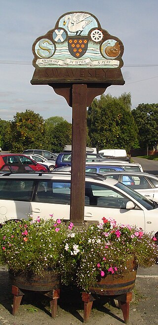
Swavesey is a village lying on the Prime Meridian in Cambridgeshire, England, with a population of 2,463. The village is situated 9 miles to the north west of Cambridge and 3 miles south east of St Ives.

<span class="mw-page-title-main">Caxton, Cambridgeshire</span> Human settlement in England

Caxton is a small rural village and civil parish in the South Cambridgeshire district of Cambridgeshire, England. It is 9 miles west of the county town of Cambridge. In 2001, the population of Caxton parish was 480 people, increasing to 572 at the 2011 Census. Caxton is most famous for the Caxton Gibbet.

<span class="mw-page-title-main">Abbots Ripton</span> Human settlement in England

Abbots Ripton is a village and civil parish in Cambridgeshire, England. Abbots Ripton is situated within Huntingdonshire which is a non-metropolitan district of Cambridgeshire as well as being an historic county of England. Abbots Ripton lies approximately 4 miles (6 km) north of Huntingdon on the B1090.

<span class="mw-page-title-main">Abbotsley</span> Human settlement in England

Abbotsley is a village and civil parish within the Huntingdonshire district of Cambridgeshire, England. It is three miles from St Neots and 14 miles from the county town of Cambridge. At the time of the 2001 census, the resident population was 425 people living in 164 households. increasing to a population of 446 at the 2011 Census.

<span class="mw-page-title-main">Buckworth</span> Human settlement in England

Buckworth is a village and civil parish in Cambridgeshire, England. Buckworth lies approximately 7 miles (11 km) northwest of Huntingdon and covers an area of 2,023 acres. It is also a part of the hundred called Leightonstone. Buckworth is situated within Huntingdonshire which is a non-metropolitan district of Cambridgeshire as well as being a historic county of England.

<span class="mw-page-title-main">Great Gransden</span> Village in Huntingdonshire, England

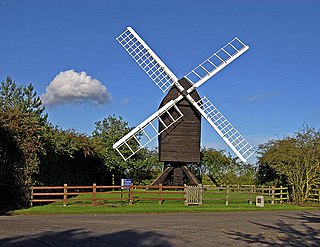
Great Gransden is a civil parish and village in the Huntingdonshire district of Cambridgeshire, England. In 2001, the parish population was 969, which rose to 1,023 at the 2011 Census. It lies 16 miles (25 km) west of Cambridge and 13 miles (21 km) south of Huntingdon. It contains the oldest post mill in England.

<span class="mw-page-title-main">Covington, Cambridgeshire</span> Human settlement in England

Covington is a village and civil parish in Cambridgeshire, England. Covington lies approximately 10 miles (16 km) west of Huntingdon near to Catworth and close to the county borders with both Bedfordshire and Northamptonshire. Covington is situated within Huntingdonshire which is a non-metropolitan district of Cambridgeshire as well as being a historic county of England. Covington. The civil parish covers an area of 1,294 acres. At the 2011 Census the population of the village was found to be less than 100 and was included in the civil parish of Tilbrook.

<span class="mw-page-title-main">Arrington, Cambridgeshire</span> Human settlement in England

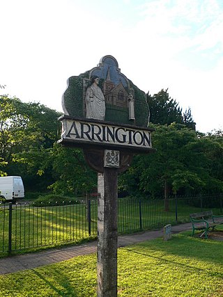
Arrington is a small village and civil parish in the South Cambridgeshire district of Cambridgeshire, England, with a population of 415 at the time of 2011 census. The village is 6 miles (10 km) north of Royston, Hertfordshire, and 9 miles (14 km) south-west of the county city of Cambridge.

<span class="mw-page-title-main">Thorney, Cambridgeshire</span> Human settlement in England

Thorney is a village in the Peterborough unitary authority in the ceremonial county of Cambridgeshire, England. Located around eight miles (13 km) east of Peterborough city centre, on the A47.

<span class="mw-page-title-main">Stretham</span> Village located in East Cambridgeshire, England

Stretham is a village and civil parish 4 miles (6 km) south-south-west of Ely in Cambridgeshire, England, about 74 miles (119 km) by road from London. Its main attraction is Stretham Old Engine, a steam-powered pump used to drain the fens. The pump is still in use today although converted to electric power. It has open days throughout the year.

<span class="mw-page-title-main">Diocese of Ely</span> Diocese of the Church of England

The Diocese of Ely is a Church of England diocese in the Province of Canterbury. It is headed by the Bishop of Ely, who sits at Ely Cathedral in Ely. There is one suffragan (subordinate) bishop, the Bishop of Huntingdon. The diocese now covers the modern ceremonial county of Cambridgeshire and western Norfolk. The diocese was created in 1109 out of part of the Diocese of Lincoln.

<span class="mw-page-title-main">Cherry Hinton</span> Human settlement in England

Cherry Hinton is a suburban area of the city of Cambridge, in the Cambridge district, in the county of Cambridgeshire, England. It is around 3 miles (4.8 km) southeast of the Cambridge city centre.

<span class="mw-page-title-main">Longstanton</span> Human settlement in England

Longstanton is a village and civil parish in South Cambridgeshire, England, 6 miles (9.7 km) north-west of Cambridge city centre. Longstanton occupies 2,775 acres (1,123 ha). Longstanton was created in 1953 from the two parishes of Long Stanton All Saints and Long Stanton St Michael. While the village is called Longstanton, the alternative form Long Stanton is still in use, for example when referring to the separate pre-1953 parishes, or to the current ecclesiastical parish.

<span class="mw-page-title-main">Tadlow</span> Human settlement in England

Tadlow is a small village and civil parish in South Cambridgeshire, England on the River Cam. It is 20 kilometres (12 mi) south-west of Cambridge and 9 kilometres (6 mi) north-east of Biggleswade, Bedfordshire. In 2001 the population was 181 and the area of the village is 681 hectares.

Bourn is a small village and civil parish in South Cambridgeshire, England. Surrounding villages include Caxton, Eltisley and Cambourne. It is 8 miles (12 km) from the county town of Cambridge. The population of the parish was 1,015 people at the time of the 2011 census.

<span class="mw-page-title-main">Hatley, Cambridgeshire</span> Human settlement in England

Hatley is a civil parish in South Cambridgeshire, England. It lies between the villages of Gamlingay and Croydon, 12 miles south-west of the city of Cambridge and eight miles south-east of the town of St Neots. In 2001, the population of Hatley parish was 205 people living in 77 households, reducing at the 2011 Census to a population of 181 in 78 households.

Pondersbridge is a village in Whittlesey civil parish, part of the Fenland district of Cambridgeshire, England. Pondersbridge is essentially a settlement which has built up around the river crossing, situated on an artificial drainage cutting called Bevill's Leam. The banks of Bevill's Leam form a strong visual boundary. The older settlement has been extended on the Main Road, north-wards by the local authority housing. The settlement has very limited services and a sporadic development pattern. The main part of Pondersbridge is contained within a triangle of roads - the B1040, the B1095 and The Drove.

References

  1. "Census Maps | Cambridgeshire Insight". Archived from the original on 28 July 2014. Retrieved 25 July 2014.
  2. "Genuki information on Boxworth". Genuki. 20 March 2003. Retrieved 11 December 2007.
  3. "British History Online guide to Boxworth". British History Online. 1989. Retrieved 14 December 2007.
  4. Eilert Ekwall, The Concise Oxford Dictionary of English Place-names, p.57.
  5. Evans, N. and Rose, S., editors, Cambridgeshire Hearth Tax Returns, Michaelmas 1664, British Record Society, London, 2000, p.73.
  6. Plaskitt, Emma. "Rolls, Mary". Oxford Dictionary of National Biography (online ed.). Oxford University Press. doi:10.1093/ref:odnb/63271.(Subscription or UK public library membership required.)
  7. "Cambridgeshire Churches". www.druidic.org.
  8. "Boxworth: Church - British History Online". www.british-history.ac.uk.
  9. "Wind Farm stirs local opposition". BBC News. 12 May 2004. Retrieved 11 December 2007.
  10. "Trevor Harley Home Page". www.trevorharley.com.