Totnes Castle is one of the best preserved examples of a Norman motte and bailey castle in England. It is situated in the town of Totnes on the River Dart in Devon. The surviving stone keep and curtain wall date from around the 14th century. From after the Norman Conquest of 1066 it was the caput of the Feudal barony of Totnes.

The Adur is a river in Sussex, England; it gives its name to the Adur district of West Sussex. The river, which is 20 miles (32 km) long, was once navigable for large vessels up as far as Steyning, where there was a large Saxon port, but by the 11th century the lower river became silted up and the port moved down to the deeper waters at the mouth of the river in Shoreham-by-Sea.

Dudley Castle is a ruined fortification in the town of Dudley, West Midlands, England. Originally a wooden motte and bailey castle built soon after the Norman Conquest, it was rebuilt as a stone fortification during the twelfth century but subsequently demolished on the orders of Henry II of England. Rebuilding of the castle took place from the second half of the thirteenth century and culminated in the construction of a range of buildings within the fortifications by John Dudley. The fortifications were slighted by order of the Parliament of England during the English Civil War and the residential buildings destroyed by fire in 1750. In the nineteenth and early twentieth century the site was used for fêtes and pageants. Today Dudley Zoo is located on its grounds.

A rape is a traditional territorial sub-division of the county of Sussex in England, formerly used for various administrative purposes. Their origin is unknown, but they appear to predate the Norman Conquest. Historically the rapes formed the basis of local government in Sussex.

Oxford Castle is a large, partly ruined medieval castle on the western side of central Oxford in Oxfordshire, England. Most of the original moated, wooden motte and bailey castle was replaced in stone in the late 12th or early 13th century and the castle played an important role in the conflict of the Anarchy. In the 14th century the military value of the castle diminished and the site became used primarily for county administration and as a prison. The surviving rectangular St George's Tower is now believed to pre-date the remainder of the castle and be a watch tower associated with the original Saxon west gate of the city.
Dial Post is a village in the Horsham District of West Sussex, England. The civil parish, where the lowest level political meetings are held, is West Grinstead in the north-east - its biggest settlement is 2 miles (3.2 km) east at Partridge Green. It has a population of around 100 based on the average headcount per inhabited dwelling. In 2001 the population of the civil parish as a whole was 2,934

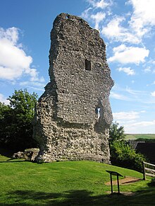
Bramber is a former manor, village and civil parish in the Horsham District of West Sussex, England. It has a ruined mediaeval castle which was the caput of a large feudal barony. Bramber is located on the northern edge of the South Downs and on the west side of the River Adur. Nearby are the communities of Steyning to the west and Upper Beeding to the east, and the other side of the river. The closest historical connection, however, is with the village of Botolphs to the south.

Abergavenny Castle is a ruined castle in the market town of Abergavenny, Monmouthshire, Wales, established by the Norman lord Hamelin de Balun c. 1087. It was the site of a massacre of Welsh noblemen in 1175, and was attacked during the early 15th-century Glyndŵr Rising. William Camden, the 16th-century antiquary, said that the castle "has been oftner stain'd with the infamy of treachery, than any other castle in Wales."

Botolphs, formerly known as Annington, is a tiny village and former civil parish, now in the parish of Bramber, in the Horsham District of West Sussex, England. It is in the Adur Valley 1.5 miles (2.4 km) southeast of Steyning on the road between Steyning and Coombes. Botolphs lies on the South Downs Way long-distance footpath. In 1931 the parish had a population of 64. On 1 April 1933 the parish was abolished and merged with Bramber.

Loughor Castle is a ruined, medieval fortification located in the town of Loughor, Wales. The castle was built around 1106 by the Anglo-Norman lord Henry de Beaumont, during the Norman invasion of Wales. The site overlooked the River Loughor and controlled a strategic road and ford running across the Gower Peninsula. The castle was designed as an oval ringwork, probably topped by wicker fence defences, and reused the remains of the former Roman fort of Leucarum.

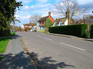
West Grinstead is a village and civil parish in the Horsham District of West Sussex, England. It lies just off the B2135 road four miles (6.3 km) northwest from Henfield. It is within the ancient division of the Rape of Bramber. The western River Adur flows through the village.
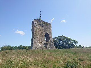
The medieval Knepp Castle is to the west of the village of West Grinstead, West Sussex, England near the River Adur and the A24.
Farnham Castle is a 12th-century castle in Farnham, Surrey, England. It was formerly the residence of the Bishops of Winchester.

Marlipins Museum, is a 12th to early-13th century Grade II* listed building on the High Street in Shoreham-by-Sea, a town in Adur district in West Sussex, England. It is distinguished by the chequerboard pattern of limestone and flint on its front façade.

The Rape of Bramber is one of the rapes, the traditional sub-divisions unique to the historic county of Sussex in England. It is the smallest Sussex rape by area. Bramber is a former barony whose original seat was the castle of Bramber and its village, overlooking the river Adur.

Erringham chapel is a former place of worship in the deserted medieval village of Old Erringham, north of Shoreham-by-Sea in the district of Adur, one of seven local government districts in the English county of West Sussex. Founded in the 11th century as a chapel of ease to St Nicolas' Church in the Saxon riverside village of Old Shoreham, it was in use for several centuries until depopulation caused Old Erringham to become unviable as a settlement. The chapel fell into ruin, and its remains have been incorporated into a barn on the farm which now occupies the site of the village. English Heritage has listed the remaining structure at Grade II for its architectural and historical importance.
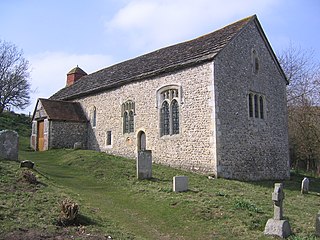
Coombes Church is a Church of England parish church in the rural hamlet of Coombes in the Adur District of West Sussex, England. It has served the rural parish, northwest of Shoreham-by-Sea and next to the River Adur, since the 11th century. Despite several re-buildings, some structural elements remain from that period. An important series of wall paintings, dating from the 12th to the 18th century, were uncovered in 1949. English Heritage has listed the church at Grade I for its architectural and historical importance.

Pennard Castle is a ruined castle, near the modern village of Pennard on the Gower Peninsula, in south Wales. The castle was built in the early 12th century as a timber ringwork following the Norman invasion of Wales. The walls were rebuilt in stone by the Braose family at the turn of the 13th and 14th centuries, including a stone gatehouse. Soon afterwards, however, encroaching sand dunes caused the site to be abandoned and it fell into ruin. Restoration work was carried out during the course of the 20th century and the remains of the castle are now protected under UK law as a Grade II* listed building.

St George's Church is an Anglican church in West Grinstead, West Sussex, England. It is in the Diocese of Chichester, occupying a rural position in the Sussex Weald by the River Adur. The oldest extant part of church dates from the early 11th century with additions in the 12th and 13th centuries. A south chapel was added in the 14th century.

The Battle of Bramber Bridge was a minor skirmish that took place on 13 December 1643, during the First English Civil War. A Royalist detachment from Arundel attempted to secure the bridge over the River Adur at Bramber in West Sussex, but found a Parliamentarian force already in possession.