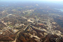
Branson has long been a popular destination for vacationers from Missouri and around the country. The collection of entertainment theaters along 76 Country Boulevard (and to a lesser extent along Shepherd of the Hills Expressway), including Dolly Parton's Stampede, has increased Branson's popularity as a tourist destination.
History
In 1882, Reuben Branson opened a general store and post office in the area.[9] Branson was formally incorporated on April 1, 1912, and construction of the Powersite Dam nearby on the White River which would form Lake Taneycomo was completed.
In 1894, William Henry Lynch bought Marble Cave (renamed "Marvel Cave") and began charging visitors to tour it. Hugo and Mary Herschend leased the cave for 99 years in 1950 and began hosting square dances in it. The Herschend Family modernized the cave with electricity and concrete staircases, and in 1960 the Herschends opened Silver Dollar City, a re-creation of a frontier town that featured five shops, a church, and a log cabin, with actors that played out the feud between the Hatfields and the McCoys.
Harold Bell Wright published his novel about the Ozarks, The Shepherd of the Hills, in 1907. The novel became an international best seller, making Wright the first millionaire author and established Branson and Southwest Missouri as a tourist destination. The Old Mill Theater began its first outdoor production based on the novel in 1960. The show, known as The Shepherd of the Hills Outdoor Drama, continued in its 61st season for 2021. The historic farm is also the home of Inspiration Tower, the Shepherd of the Hills Adventure Park as well as numerous other shows and attractions.
The Harold Bell Wright Museum is located within The World's Largest Toy Museum complex. Mayor of Branson for 12 years and entrepreneur Jim Owen built the first theater in 1934 on Commercial Street, originally called "The Hillbilly Theater", which began to attract people from far and wide to tour the area. 1959 saw the completion of Table Rock Dam on the White River, which created Table Rock Lake. In 1959, the Mabe Brothers started a band that, in 1961, would become the first music show in Branson. Taking their name from the parts they played in the Shepherd of the Hills Outdoor Drama, they became known as the Baldknobber Hillbilly Jamboree.
In 1962, Paul Henning, inspired by a Boy Scout camping trip to the Ozarks, created The Beverly Hillbillies, which ran on first-run television until 1971. Henning later donated 1,534 acres (6.21km2) for the Ruth and Paul Henning Conservation Area near Branson. He also donated the modified 1921 Oldsmobile truck used as the vehicle in the series to the College of the Ozarks, where it is on display in the Ralph Foster Museum.
The Presley family became the first to move their show (Presleys' Country Jubilee) to Highway 76 in 1967, followed a year later by the Baldknobbers. Eventually Branson would have more than 50 theaters, most of them located on Highway 76.
Also in 1983, the 7,500-seat Swiss Villa Amphitheatre opened in Lampe, southwest of Branson. The outdoor amphitheater brought in acts like Def Leppard, Lynyrd Skynyrd, REO Speedwagon, Steppenwolf, and Ozzy Osbourne. Closing in the early 2000s, it reopened in 2010 as the Black Oak Mountain Amphitheater. Closing suddenly in 2013, it went unused until relaunching live music events in 2021.
In 1987, Boxcar Willie became the first internationally known entertainer to purchase a theater in Branson and have a permanent performance schedule there.
In 1989, Shoji Tabuchi opened his first theater in Branson (converting the Ozarks Auto Museum on West 76 Highway into a theater). He then built a new theater on Shepherd of the Hills Expressway in 1990, while Mel Tillis moved into Shoji's old theater. In 1990-1991 several nationally known stars such as Jim Stafford, Ray Stevens, Mickey Gilley, and Moe Bandy opened their own theaters. Along with these national stars, many home-grown shows also had theaters. The Lowe Family featured their show and hosted nationally known stars like Conway Twitty, Loretta Lynn, Vern Gosdin, Waylon Jennings, and others. 76 Music Hall (now known as the Grand Country Music Hall) became the first theater to have three different shows a day performing in different time slots. In 1991, local producer and entertainer Bob Nichols opened the first morning show and the following year, Buck Trent became the first nationally known star to star in a morning show.
The increasing number of theaters and other attractions opening in Branson drew the attention of 60 Minutes, which aired an episode about Branson on December 8, 1991, and called it the "live music capital of the entire universe".[10]
Andy Williams built his theater in Branson, opening on May 1, 1992, calling it the Moon River Theatre. The Glen Campbell Goodtime Theatre opened in 1994, starring Glen along with his "Goodtime Band", daughter Debbie Campbell, the Matthew Dickens Dancers, and comedian ventriloquist Jim Barber. Also headlining their own theaters were Tony Orlando (Yellow Ribbon Theater) and Bobby Vinton (Blue Velvet Theater). In 1998, the Acrobats of China arrived in Branson, making them one of the first international shows to call Branson home. They opened their theatre, the New Shanghai Theatre, in 2005. In 2006, Dick Clark's American Bandstand Theatre opened and is the most recent new theater to be built on Route 76. Branson has continued to add theaters (the most recent being the Sight & Sound Theatres) and shows; it refers to itself as "the live music show capital of the world".[11]
Use of social media is now an important factor in putting the spotlight on Branson. For example, the Petersens, a family bluegrass band, forced by COVID-19 to quit touring or performing live at Branson's Little Opry Theatre for much of 2020, found that YouTube was an alternative, with their videos generating more than 70 million views. In addition, 65% of their nearly 600,000 subscribers live outside the United States. (Figures as of October 2021 are as found on YouTube or cited by the Petersens). Thus this "American roots" band is generating a wide range of interest in Branson as a tourist destination.[12][13]
2012 tornado
Just after 1 a.m. on February 29, 2012, the city of Branson sustained damage from an EF-2 tornado in the 2012 Leap Day tornado outbreak. At least 37 injuries were reported, most being cuts and bruises, with the most serious injury being an 80-year-old woman with a head injury.[14][15] Most of the tourist attractions and businesses were undamaged and remained open after the storm, although at least 11 buildings suffered more than $3 million in total damage. As of November 2012, most of the damage was repaired.[16] Mary Jane Rice, a spokeswoman for Branson Area Chamber of Commerce, told the AP that February is generally a slow time for business and most of the damage would be cleaned up in the next few days.[17] The tornado followed a 22-mile-long (35km) path from Kimberling City, Missouri, across Table Rock Lake and along the entertainment strip Missouri Route 76 (now 76 country boulevard) before hitting the downtown area where it blew out or cracked windows in 219 of the hotel rooms in the 12-story/295 room Hilton Branson Convention Center. The tornado extensively damaged three of Branson's 50-plus theatres— (Americana Theater, Branson Variety Theater and Dick Clark's American Bandstand Theater) and there was damage to portions of Branson Landing on Lake Taneycomo and the Veterans Memorial Museum. Vehicles at the Ride the Ducks water/land attraction were flipped over, but officials said they were not damaged enough to be put out of service.[18][19][20]
Entertainment and performing arts
Branson is famous for its numerous entertainment theaters, which host residency shows in music, dance, magic, and other performing arts.
One prominent theater in Branson is the Andy Williams Performing Arts Center and Theatre. It hosts annual shows year round, but most prominent are the Christmas shows hosted by The Osmonds and The Lennon Sisters.[21]
Branson Landing opened in the summer of 2006[23] on the Lake Taneycomo waterfront in downtown Branson. The lakefront project includes retail space with Bass Pro Shops and Belk as anchors in an outdoor shopping mall of stores and restaurants. It also features a scenic boardwalk along the lakefront with the Branson Landing Fountains at the heart of the property as well as a Hilton Hotel. Branson Landing has been known to host summer concerts and other special events throughout the year. The convention center, situated between Branson Landing and Historic Downtown Branson, opened September 7, 2007. The Branson Scenic Railway is located in the old depot, across from Branson Landing.
Due to Branson being known for family-oriented tourism, casino gambling is frowned upon and it does not exist in this area. However, Branson's neighboring cities do offer those types of entertainments for those who enjoy gambling.[24]
Finally, Branson's ferris wheel, moved from Chicago's Navy Pier in 2016, provides a scenic view of the Ozarks from 150 feet.[25]
According to the United States Census Bureau, the city has a total area of 20.80 square miles (53.87km2), of which 20.63 square miles (53.43km2) is land and 0.17 square miles (0.44km2) is water.[27]
The 2020 United States census[30] counted 12,638 people, 4,857 households, and 2,809 families in Branson. The population density was 591.9 per square mile (228.6/km2). There were 8,347 housing units at an average density of 391.0 per square mile (151.0/km2). The racial makeup was 80.57% (10,182) white, 2.46% (311) black or African-American, 0.9% (114) Native American, 2.68% (339) Asian, 0.09% (12) Pacific Islander, 4.69% (593) from other races, and 8.6% (1,087) from two or more races. Hispanic or Latino of any race was 12.9% (1,489) of the population.
Of the 4,857 households, 22.5% had children under the age of 18; 42.4% were married couples living together; 38.9% had a female householder with no husband present. Of all households, 33.1% consisted of individuals and 15.3% had someone living alone who was 65 years of age or older. The average household size was 2.3 and the average family size was 2.9.
19.3% of the population was under the age of 18, 10.5% from 18 to 24, 21.3% from 25 to 44, 19.8% from 45 to 64, and 20.3% who were 65 years of age or older. The median age was 38.9 years. For every 100 females, the population had 73.2 males. For every 100 females ages 18 and older, there were 70.6 males.
The 2016-2020 5-year American Community Survey[31] estimates show that the median household income was $44,184 (with a margin of error of +/- $6,551) and the median family income was $50,216 (+/- $10,990). Males had a median income of $23,413 (+/- $3,429) versus $22,091 (+/- $3,304) for females. The median income for those above 16 years old was $22,771 (+/- $2,713). Approximately, 15.9% of families and 22.3% of the population were below the poverty line, including 40.2% of those under the age of 18 and 10.3% of those ages 65 or over.
2010 census
As of the census[32] of 2010, there were 10,520 people, 4,688 households, and 2,695 families living in the city. The population density was 509.9 inhabitants per square mile (196.9/km2). There were 8,599 housing units at an average density of 416.8 per square mile (160.9/km2). The racial makeup of the city was 89.0% White, 2.0% African American, 0.9% Native American, 1.5% Asian, 0.1% Pacific Islander, 3.9% from other races, and 2.6% from two or more races. Hispanic or Latino of any race were 8.8% of the population.
There were 4,688 households, of which 23.2% had children under the age of 18 living with them, 42.8% were married couples living together, 10.7% had a female householder with no husband present, 3.9% had a male householder with no wife present, and 42.5% were non-families. 32.8% of all households were made up of individuals, and 13.5% had someone living alone who was 65 years of age or older. The average household size was 2.20 and the average family size was 2.77.
The median age in the city was 41.2 years. 18.8% of residents were under the age of 18; 10.2% were between the ages of 18 and 24; 25.7% were from 25 to 44; 25.6% were from 45 to 64; and 19.6% were 65 years of age or older. The gender makeup of the city was 47.9% male and 52.1% female.
2000 census
As of the census[6] of 2000, there were 6,050 people, 2,701 households, and 1,661 families living in the city. The population density was 374.0 inhabitants per square mile (144.4/km2). There were 3,366 housing units at an average density of 208.1 per square mile (80.3/km2). The racial makeup of the city was 94.50% White, 0.84% African American, 0.86% Native American, 0.71% Asian, 0.03% Pacific Islander, 1.47% from other races, and 1.59% from two or more races. Hispanic or Latino of any race were 4.26% of the population.
There were 2,701 households, out of which 24.3% had children under the age of 18 living with them, 48.9% were married couples living together, 9.4% had a female householder with no husband present, and 38.5% were non-families. 31.9% of all households were made up of individuals, and 14.1% had someone living alone who was 65 years of age or older. The average household size was 2.21 and the average family size was 2.76.
In the city, the population was spread out, with 20.3% under the age of 18, 8.2% from 18 to 24, 24.4% from 25 to 44, 27.0% from 45 to 64, and 20.2% who were 65 years of age or older. The median age was 43 years. For every 100 females, there were 86.7 males. For every 100 females age 18 and over, there were 83.2 males.
The median income for a household in the city was $31,997, and the median income for a family was $43,145. Males had a median income of $31,769 versus $21,223 for females. The per capita income for the city was $20,461. 12.1% of the population and 9.7% of families were below the poverty line. 15.6% of those under the age of 18 and 17.0% of those 65 and older were living below the poverty line.
Education
Branson R-IV School District operates four elementary schools, Branson Jr. High School and Branson High School.[33] The town has a lending library, the Taneyhills Community Library.[33]
U.S. Route 65 runs north and south, connecting Branson to Springfield to the north, and Little Rock to the south. Missouri Route 76 ran through Branson. In 2020, Route 76 was rerouted onto the existing Ozark Mountain Highroad replacing Route 465. The old alignment now forms 76 Country Boulevard.[citation needed]
Air
Branson is served primarily by Branson Airport, the closest commercial airport, which opened in May 2009. It is the largest privately owned commercial airport in the United States. Over the years, the airport has had on-again off-again service from carriers such as AirTran, Sun Country, and Frontier.
Taney County is a county in the southwestern portion of the U.S. state of Missouri. As of the 2020 census, the population was 56,066. Its county seat is Forsyth. It is included in the Branson, Missouri, Micropolitan Statistical Area.
Camdenton is a city in and the county seat of Camden County, Missouri, United States. Its population was 3,718 at the 2010 census. The city is enveloped by the Lower Niangua arm of the Lake of the Ozarks, and serves as a popular trade point for visitors to the area.
Ozark is a city in and the county seat of Christian County, Missouri. Its population was 21,284 as of the 2020 census. Ozark is also the third largest city in the Springfield, Missouri Metropolitan Area, and is centered along a business loop of U.S. Route 65, where it intersects with Missouri Route 14.
Buffalo is a city in and the county seat of Dallas County, Missouri, United States. The population was 3,290 at the 2020 census.
West Plains is a city in and the county seat of Howell County, Missouri, United States. The population was 12,184 at the 2020 census.
Annapolis is a city located in southern Iron County, Missouri, United States. The population was 250 at the 2020 census.
Pierce City, formerly Peirce City, is a city in southwest Lawrence and northwest Barry counties, in southwest Missouri, United States. The population was 1,292 at the 2010 census. In 2010, the town annexed property along Route 97 into Barry County to a point just north of U.S. Route 60. It was estimated to be 1,309 by the City of Pierce City as of July 1, 2019.
Eldon is a city in Miller County, Missouri, United States, located 30 miles (48 km) southwest of Jefferson City. The population was 4,416 as of the 2020 census.
Northmoor is a city in Platte County, Missouri, and is part of the Kansas City metropolitan area. The population was 325 at the 2010 census.
Bull Creek is a village in northwest Taney County, Missouri, United States. The population was 426 at the 2020 census. It is part of the Branson, Missouri Micropolitan Statistical Area.
Merriam Woods is a city in Taney County, Missouri, United States. The population was 2,006 at the 2020 census. It is part of the Branson, Missouri Micropolitan Statistical Area.
Rockaway Beach is a city in Taney County, Missouri, United States. The population was 829 at the 2020 census. It lies on the shoreline of the White River.
Poplar Bluff is a city in Butler County in southeastern Missouri, United States. It is the county seat of Butler County and is known as "The Gateway to the Ozarks" among other names. The population was 16,225 at the 2020 census. The Poplar Bluff Micropolitan Statistical Area consists of all of Butler County. The city is at the crossroads of U.S. Route 60 and U.S. Route 67.
De Soto is a city in Jefferson County, Missouri, United States. The population was 6,449 at the 2020 census and the city is part of the St. Louis metropolitan area. The Van Metre family were first to settle in 1803. The town was organized in 1857 and is named for the explorer Hernando De Soto, who claimed the Louisiana Territory for Spain. De Soto was the city closest to the mean center of U.S. population in 1980. The city celebrated its Bicentennial in 2003. The city made national news on and after May 6, 2003, when straight-line winds and a tornado struck.
Branson West is a city in Stone County, Missouri, United States. The population was 484 at the 2020 census.
Indian Point is a village in Stone County, Missouri, United States. The population was 550 at the 2020 census. It is part of the Branson, Missouri Micropolitan Statistical Area.
Lake Ozark is a city in Camden and Miller counties in the U.S. state of Missouri, near its namesake, the Lake of the Ozarks. The population was 2,077 at the 2020 census.
Osage Beach is a city in Camden and Miller counties in the U.S. state of Missouri, near the Lake of the Ozarks. Most of the city is in Camden County, while a small eastern sliver is in Miller County. The population was 4,792 at the 2020 census.
Oak Grove is a city in Jackson and Lafayette counties in the U.S. state of Missouri. The population was 8,157 at the 2020 census. It is part of the Kansas City metropolitan area.
Kirbyville is a village in Taney County, Missouri, United States. The population was 195 at the 2020 census. It is part of the Branson, Missouri Micropolitan Statistical Area.
↑ Coulter, Ronald L.; Hermans, Charles M.; Parker, R. Stephen (September 1, 2013). "Religiosity and generational effects on gambling: Support for and opposition to introducing casino gambling in a non-gambling tourist entertainment environment". Journal of Business Research. 66 (9): 1682–1688. doi:10.1016/j.jbusres.2012.12.015.
This page is based on this Wikipedia article Text is available under the CC BY-SA 4.0 license; additional terms may apply. Images, videos and audio are available under their respective licenses.


