
Hampden County is a non-governmental county located in the Pioneer Valley of the state of Massachusetts, in the United States. As of the 2010 census, Hampden County's population was 463,490. As of 2019, Hampden County's estimated population was 466,372. Its traditional county seat is Springfield, the Connecticut River Valley's largest city, and economic and cultural capital; with an estimated population of 154,758, approximately 1 in 3 residents of Hampden County live in Springfield. Hampden County was split from Hampshire County in 1812, because Northampton, Massachusetts, was made Hampshire County's "shire town" in 1794; however, Springfield—theretofore Hampshire County's traditional shire town, dating back to its founding in 1636—grew at a pace far quicker than Northampton and was granted shire town-status over its own, southerly jurisdiction. It was named for parliamentarian John Hampden. To the north of Hampden County is modern-day Hampshire County; to the west is Berkshire County; to the east is Worcester County; to the south are Litchfield County, Hartford County, and Tolland County in Connecticut.
Interstate 91 (I-91) is an Interstate Highway in the New England region of the United States. It provides the primary north–south thoroughfare in the western part of the region. The Interstate generally follows the course of the Connecticut River. Its southern end is in New Haven, Connecticut, at Interstate 95. The northern end of the American-maintained road is in the village of Derby Line, Vermont, at the Canadian border. I-91 then continues past the Derby Line–Rock Island Border Crossing, where the road's official name changes to Autoroute 55. I-91 is the longest of three Interstate highways whose entire route is located within the New England states and is also the only primary (two-digit) Interstate Highway in New England to intersect all five of the others that run through the region. The largest cities along its route are New Haven, Connecticut, Hartford, Connecticut, Springfield, Massachusetts, Northampton, Massachusetts, Greenfield, Massachusetts, Brattleboro, Vermont, White River Junction, Vermont, and St. Johnsbury, Vermont in order from south to north.

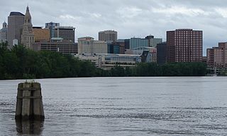
Springfield is a city in the state of Massachusetts, United States, and the seat of Hampden County. Springfield sits on the eastern bank of the Connecticut River near its confluence with three rivers: the western Westfield River, the eastern Chicopee River, and the eastern Mill River. As of the 2010 Census, the city's population was 153,060. As of 2019, the estimated population was 153,606, making it the third-largest city in Massachusetts, the fourth-most populous city in New England after Boston, Worcester, and Providence, and the 12th-most populous in the Northeastern United States. Metropolitan Springfield, as one of two metropolitan areas in Massachusetts, had a population of 692,942 as of 2010.

Rowe is a town in Franklin County, Massachusetts, United States. The population was 393 at the 2010 census. It is part of the Springfield, Massachusetts Metropolitan Statistical Area.

Holyoke is a city in Hampden County, Massachusetts, United States, that lies between the western bank of the Connecticut River and the Mount Tom Range. As of the 2010 census, the city had a population of 39,880. As of 2019, the estimated population was 40,117. Located 8 miles (13 km) north of Springfield, Holyoke is part of the Springfield Metropolitan Area, one of the two distinct metropolitan areas in Massachusetts.

Westfield is a city in Hampden County, in the Pioneer Valley of western Massachusetts, United States. Westfield was first settled in 1660. It is part of the Springfield, Massachusetts Metropolitan Statistical Area. The population was 41,094 at the 2010 census.

The city of Northampton is the county seat of Hampshire County, Massachusetts, United States. As of the 2010 census, the population of Northampton was 28,549.

The Pioneer Valley is the colloquial and promotional name for the portion of the Connecticut River Valley that is in Massachusetts in the United States. It is generally taken to comprise the three counties of Hampden, Hampshire, and Franklin. The lower Pioneer Valley corresponds to the Springfield, Massachusetts metropolitan area, the region's urban center, and the seat of Hampden County. The upper Pioneer Valley region includes the smaller cities of Northampton and Greenfield, the county seats of Hampshire and Franklin counties, respectively.

West Springfield is a city in Hampden County, Massachusetts, United States. It is part of the Springfield, Massachusetts Metropolitan Statistical Area. The population was 28,391 at the 2010 census. The city is also known as "West Side", in reference to the fact that it is on the western side of the Connecticut River from Springfield, a fact which played a major part in the town's early history.
U.S. Route 5 is a north–south United States highway running through the New England states of Connecticut, Massachusetts, and Vermont. Significant cities along the route include New Haven, Connecticut; Hartford, Connecticut; and Springfield, Massachusetts. From Hartford northward to St. Johnsbury, Vermont, the road closely follows the route of the Connecticut River.
The greater Hartford–Springfield area is an urban region and surrounding suburban areas that encompasses both north-central Connecticut and the southern Connecticut River Valley in western Massachusetts; its major city centers are Springfield, Massachusetts and Hartford, Connecticut.
Metro Center is the original colonial settlement of Springfield, Massachusetts, located beside a bend in the Connecticut River. As of 2019, Metro Center features a majority of Western Massachusetts' most important cultural, business, and civic venues. Metro Center includes Springfield's Central Business District, its Club Quarter, its government center, its convention headquarters, and in recent years, it has become an increasingly popular residential district, especially among young professionals, empty-nesters, and creative types, with a population of approximately 7,000 (2010.)

The North End of Springfield, Massachusetts is a name that describes three distinct Springfield neighborhoods: Brightwood, Memorial Square, and Liberty Heights. For more than a century, Springfield's North End neighborhood has served as a first home for some of the city's various immigrant communities, from Greeks in Memorial Square to Russians in Liberty Heights. As of 2011, the contemporary Puerto Rican flavor of the North End is evident in numerous banners depicting traditional Carnival masks and the coquí, Puerto Rico's unofficial mascot.
South End is a neighborhood in the city of Springfield, Massachusetts. Interstate 91 separates it from the Connecticut River and the Basketball Hall of Fame museum and entertainment complex.
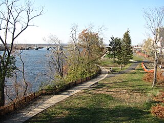
The Connecticut River Walk is partially constructed park and bikeway in Springfield, Massachusetts, United States, along the banks of New England's largest river, the Connecticut River. Currently, Springfield's section of this park is 3.7 miles (6 km) long, running from Chicopee, Massachusetts to the South End Bridge in Springfield, Massachusetts. Unusual features of the trail include its path alongside an active train line, making it a "rail-with-trail," and its passing in very close proximity to the Naismith Memorial Basketball Hall of Fame. The longest river in New England, the Connecticut River is the Knowledge Corridor's most prominent natural asset. For centuries it has been a source of regional identity and pride; however, currently most residents are cut off from it by Interstate 91 - a 1960s-era elevated highway, which has become a major inhibitor to Springfield's economic and recreational riverfront growth, especially in recent years.

The City of Springfield, Massachusetts, has 19 distinct neighborhoods. Many feature subdivisions known by other names, such as The X, Hungry Hill, and Mason Square. Springfield's neighborhoods fan out north, south, and east, from its original, colonial settlement in what is now Metro Center.
The Mill River is a 1.25-mile (2.01 km) long tributary of the Connecticut River in Springfield, Massachusetts. It flows from Watershops Pond to its confluence with the Connecticut River. It is referred to as "The Miracle Mile" in a 2009 master's thesis that outlines possibilities for reclaiming the river's mouth as a recreational area. As of 2011, the final 350 feet (110 m) of the river, including its mouth, is confined in a pipe underneath Interstate 91, railroad tracks and a car dealership. Many Springfield residents bemoan the loss of the Mill River as a recreational area, and hope to gain greater access to both it and Connecticut Rivers in upcoming years. As it has for over a century, today the Mill River serves as a barrier between Springfield neighborhoods. Surrounding it are some of the most densely urbanized locations in Springfield.

Springfield, Massachusetts, was founded in 1636 as Agawam Plantation, after a nearby village of Algonkian-speaking Native Americans. It was the northernmost settlement of the Connecticut Colony. The settlement defected from Connecticut after four years, however, later joining forces with the coastal Massachusetts Bay Colony. The town changed its name to Springfield, and changed the political boundaries among what later became New England states. The history of Springfield, Massachusetts springs in large part from its favorable geography, situated on a steep bluff overlooking the Connecticut River's confluence with three tributaries. It was a Native American crossroad for two major trade routes: Boston-to-Albany and New York City-to-Montreal. Springfield also sits on some of the northeastern United States' most fertile soil.

Ingleside is a neighborhood in Holyoke, Massachusetts located to the south of the city center, approximately 2 miles from downtown. The neighborhood features access to the Connecticut River through the Sue Ellen Panitch River Center and the Land of Providence reservation. Ingleside is also home to the Holyoke Mall, the Nuestras Raices farm, the Sisters of Providence of Holyoke, the Providence Behavioral Health Hospital, and several recreational and historical venues.

Springdale is a neighborhood in Holyoke, Massachusetts located to the south of the city center, approximately 1 mile (1.6 km) from downtown, on the banks of the Connecticut River. The neighborhood features Springdale Park, originally known as Riverside Park, which was designed by the influential Olmsted Brothers landscape architecture firm, as well as light industry and machine shops, residential housing, and the central supply warehouse of Holyoke Public Schools. The mixed zoning neighborhood was developed as a streetcar suburb by brickmaker John J. Prew, who gave the area its name and devised the first street plans and building lots for the area in 1887 as housing for millworkers of South Holyoke. Since 1984, Springdale Park has hosted the city's annual Western Massachusetts Puerto Rican Parade, a three-day annual event in June celebrating the city's Latin culture and music.

