Bristol Bridge

Last updated

Bristol Bridge
Bristol Bridge (April 2011).jpg
Bristol Bridge from Welsh Back
Coordinates 51°27′13″N2°35′29″W / 51.4536°N 2.5913°W / 51.4536; -2.5913
CarriesMotor vehicles, pedestrians
Crosses Bristol Harbour / River Avon
Locale Bristol
Maintained by Bristol City Council
History
Opened1768
Location
Bristol Bridge
Bristol Bridge from Castle Park Bristol bridge.jpg
Bristol Bridge from Castle Park

Bristol Bridge is a bridge over the floating harbour in Bristol, England. The floating harbour was constructed on the original course of the River Avon, and there has been a bridge on the site since long before the harbour was created by impounding the river in 1809. The current bridge was completed in 1768 and is a Grade II listed building. [1]

Contents

Bristol Bridge is the furthest downstream of the fixed bridges across the harbour, and marks the limit of navigation for any vessel that is unable to pass beneath its arches. Downstream from the bridge the harbour is lined by wharves and warehouses, with Welsh Back to the west and Redcliffe Back to the east. Upstream, the land to the west is occupied by Castle Park, created on an area destroyed by bombing during the Second World War, whilst the opposite bank is occupied by the former Georges Bristol Brewery, now redeveloped as Finzels Reach. [2]

History

Bristol's name is derived from the Saxon Brycgstow or 'Brigstowe', meaning the 'place of the bridge'. [3] However, it is unclear when the first bridge over the Avon was built. The Avon has a high tidal range, so the river could have been forded twice a day. The name may therefore refer to the many smaller bridges over the Avon's tributary, the River Frome, constructed in the marshy surrounding area, which is now largely built over.

The first stone bridge was built in 1247, and houses with shopfronts were built on it. [4] [5] A 17th-century illustration shows that these bridge houses were five stories high, including the attic rooms, and that they overhung the river much as Tudor houses would overhang the street. [6] The bridge was regarded as a place where the wealthy would live, hosting a community of goldsmiths. [5] Houses on the bridge were attractive and charged high rents as they had so much passing traffic, and had plenty of fresh air while waste could be dropped into the river. [6] Its population was also perceived to be strongly parliamentarian. [6] During the Civil War in 1647, the bridge was struck by fire, with 24 houses being burnt. [5]

Original caption: 'Bristoll Bridg over Avon flu' Millerd1728dbridge.jpg
Original caption: 'Bristoll Bridg over Avon flu'

In 1760 a bill to replace the bridge was carried through parliament by the Bristol MP Sir Jarrit Smyth. [7] By the early 18th century, increase in traffic and the encroachment of shops on the roadway made the bridge fatally dangerous for many pedestrians, but despite a campaign by Felix Farley in his Journal, no action was taken until a shopkeeper on the bridge employed James Bridges to provide designs. The commission accepted the design of James Bridges after many long drawn out disputes which are still unclear. Bridges fled to the West Indies in 1763 leaving Thomas Paty to complete it between 1763 and 1768. The bridge that was completed by 1768 largely resembles the present structure. [5] Resentment at the tolls exacted to cross the new bridge occasioned the Bristol Bridge Riot of 1793. The toll houses were turned into shops before they were removed. In the 19th century, the roadway was again congested, so walkways were added on either side, the supporting columns disguising the classical Georgian design. The current metal railings date from the 1960s.

Before the Second World War, Bristol Bridge was an important transport hub. It was the terminus of tram routes to Knowle, Bedminster and Ashton Gate, and other trams also stopped here. [8] It lost importance when Temple Way was built further upstream in the 1930s, [9] and when the tram system closed in 1941.

Bristol Bridge was closed to private motor cars and goods vehicles under 7.5 tonnes in 2020 as part of Bristol City Council's initiative to improve air quality, accelerated in response to the COVID-19 pandemic. [10]

Bristolharbourmap.png

  1. Prince's Wharf, including M Shed, Pyronaut and Mayflower adjoining Prince Street Bridge
  2. Dry docks: SS Great Britain, the Matthew
  3. St Augustine's Reach, Pero's Bridge
  4. Bathurst Basin
  5. Queen Square
  6. Bristol Temple Meads railway station
  7. Castle Park
  8. Redcliffe Quay and Redcliffe Caves
  9. Baltic Wharf marina
  10. Cumberland Basin & Brunel Locks
  11. The New Cut
  12. Netham Lock, entrance to the Feeder Canal
  13. Totterdown Basin
  14. Temple Quay
  15. The Centre
  16. Canons Marsh, including Millennium Square and We The Curious
  17. Underfall Yard
  18. Bristol Bridge and Welsh Back

See also

Related Research Articles

<span class="mw-page-title-main">Bristol Temple Meads railway station</span> Major railway station for the city of Bristol, England

Bristol Temple Meads is the oldest and largest railway station in Bristol, England. It is located 118 miles 31 chains away from London Paddington. It is an important transport hub for public transport in the city; there are bus services to many parts of the city and surrounding districts, with a ferry to the city centre. Bristol's other major station, Bristol Parkway, is a more recent station on the northern outskirts of the conurbation. It is the busiest station in South West England.

<span class="mw-page-title-main">Bristol Harbour</span> Harbour in Bristol, England

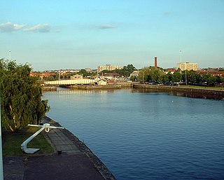
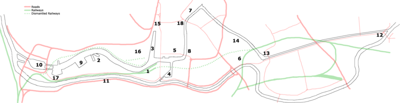
Bristol Harbour is the harbour in the city of Bristol, England. The harbour covers an area of 70 acres. It is the former natural tidal river Avon through the city but was made into its current form in 1809 when the tide was prevented from going out permanently. A tidal by-pass was dug for 2 miles through the fields of Bedminster for the river, known as the "River Avon New Cut", "New Cut", or simply "The Cut". It is often called the Floating Harbour as the water level remains constant and it is not affected by the state of the tide on the river in the Avon Gorge, The New Cut or the natural river southeast of Temple Meads to its source.

<span class="mw-page-title-main">Bristol Harbour Railway</span>

The Bristol Harbour Railway was a standard-gauge industrial railway that served the wharves and docks of Bristol, England. The line, which had a network of approximately 5 mi (8.0 km) of track, connected the Floating Harbour to the GWR mainline at Bristol Temple Meads. Freight could be transported directly by waggons to Paddington Station in London. The railway officially closed in 1964.

<span class="mw-page-title-main">Spike Island, Bristol</span> Human settlement in England

Spike Island is an inner city and harbour area of the English port city of Bristol, adjoining the city centre. It comprises the strip of land between the Floating Harbour to the north and the tidal New Cut of the River Avon to the south, from the dock entrance to the west to Bathurst Basin in the east. The island forms part of Cabot ward. The area between the Docks and New cut to the east of Bathurst Basin is in the neighbourhoods of Redcliffe and St Philip's Marsh.

<span class="mw-page-title-main">Buildings and architecture of Bristol</span>

Bristol, the largest city in South West England, has an eclectic combination of architectural styles, ranging from the medieval to 20th century brutalism and beyond. During the mid-19th century, Bristol Byzantine, an architectural style unique to the city, was developed, and several examples have survived.

<span class="mw-page-title-main">Cabot, Bristol (former ward)</span> Human settlement in England

Cabot was a council ward that covered the centre of Bristol, England. It took its name from the Cabot Tower, a memorial tower on Brandon Hill that was built to commemorate John Cabot's voyage and "discovery" of North America. The ward was abolished in 2016.

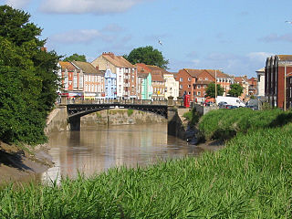
Redcliffe, also known as Redcliff, is a district of the English port city of Bristol, lying south-east of the city centre. It is bounded by the loop of the Floating Harbour to the west, north and east, together with the New Cut of the River Avon to the south. Most of Redcliffe lies within the city ward of Lawrence Hill, although the westernmost section, including the cliffs and hill from which the area takes its name, is in Cabot ward. Bristol Temple Meads station is located in Redcliffe.

<span class="mw-page-title-main">Netham Lock</span>

Netham Lock is the point at Netham in Bristol at which boats from the River Avon, acting as part of the Kennet and Avon Canal, gain access to Bristol's Floating Harbour.

<span class="mw-page-title-main">Cumberland Basin (Bristol)</span> Place in Bristol, England

The Cumberland Basin is the main entrance to the docks of the city of Bristol, England. It separates the areas of Hotwells from the tip of Spike Island.

<span class="mw-page-title-main">Underfall Yard</span> Boatyard in Bristol with mechanism for maintaining water and silt levels in the harbour

The Underfall Yard is a historic boatyard on Spike Island serving Bristol Harbour in England.

<span class="mw-page-title-main">Bathurst Basin</span>

Bathurst Basin is a small triangular basin adjoining the main harbour of the city of Bristol, England. The basin takes its name from Charles Bathurst, who was a Bristol MP in the early 19th century.

<span class="mw-page-title-main">New Cut, Bristol</span> River in Bristol, England

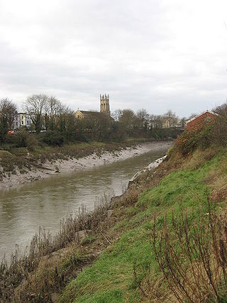
The New Cut is an artificial waterway which was constructed between 1804 and 1809 to divert the tidal river Avon through south and east Bristol, England. This was part of the process of constructing Bristol's Floating Harbour, under the supervision of engineer William Jessop. The cut runs from Totterdown Basin at the eastern end of St Phillip's Marsh, near Temple Meads, to the Underfall sluices at Rownham in Hotwells and rejoining the original course of the tidal Avon.

<span class="mw-page-title-main">The Centre, Bristol</span> Open space in Bristol, England, UK

The Centre is a public open space in the central area of Bristol, England, created by covering over the River Frome. The northern end of The Centre, known as Magpie Park, is skirted on its western edge by Colston Avenue; the southern end is a larger paved area bounded by St Augustine's Parade to the west, Broad Quay the east, and St Augustine's Reach to the south, and bisected by the 2016 extension of Baldwin Street. The Centre is managed by Bristol City Council.

<span class="mw-page-title-main">Port of Bridgwater</span> Port in England

The Port of Bridgwater is a port, originally located in the town of Bridgwater, Somerset, England. Created under the Bridgwater Navigation and Quays Act 1845 it extends from Brean Down to Hinkley Point in Bridgwater Bay, and parts of the rivers Parrett, River Brue and River Axe. Although no ships now dock in the town, in 2001 103,613 (metric) tonnes of cargo were handled within the area of the Port Authority, most of which were stone products through the wharf at Dunball.

<span class="mw-page-title-main">Ashton Avenue Bridge</span> Bridge in Bristol, England

The Ashton Avenue Bridge is a pedestrian, cycling and busway bridge in Bristol, England. Grade II listed, it was constructed as a road-rail bridge as part of the Bristol Harbour Railway. It now carries a Bristol MetroBus guided busway route and National Cycle Network cycle routes.

<span class="mw-page-title-main">Temple Quay</span>

Temple Quay is an area of mixed-use development in central Bristol, England. The project was initiated by Bristol Development Corporation in 1989, under the name Quay Point until 1995. In that year it was handed over to English Partnerships, under whom development eventually started in 1998. It is bounded by Temple Way to the west and Bristol Temple Meads railway station to the southeast; to the northeast the development was bounded by Bristol Floating Harbour until 2002, when development of Temple Quay North started on the harbour's other side. In 2012 the whole area became part of Bristol Temple Quarter Enterprise Zone.

<span class="mw-page-title-main">Bristol Feeder Canal</span>

The Bristol Feeder Canal is a body of water in Bristol, England, that connects the Floating Harbour with the River Avon.

<span class="mw-page-title-main">Redcliffe Caves</span> Tunnels in Bristol, England

Redcliffe Caves are a series of man made tunnels beneath the Redcliffe area of Bristol, England.

<span class="mw-page-title-main">20th century road schemes in Bristol</span>

Road building was central to planning policy for much of the 20th century in Bristol, England. The planned road network evolved over time but at its core was a network of concentric ring roads and high-capacity radial roads.

<span class="mw-page-title-main">Welsh Back, Bristol</span> Wharf and street in the city of Bristol, England

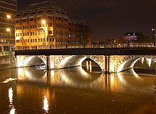
Welsh Back is a wharf and street alongside the floating harbour in the centre of the city of Bristol, England. The wharf and street extend some 450 metres (1,480 ft) along the west side of the harbour between Bristol Bridge and Redcliffe Bridge. At the northern end, the street and wharf are immediately adjacent, but to the south they are separated by a range of single story transit sheds. The wharf is a grade II listed structure and takes its name because it was freqented by vessels from Welsh ports.

References

  1. Historic England. "Bristol Bridge (1204252)". National Heritage List for England . Retrieved 5 January 2022.
  2. "The Inner Harbour". Bristol Floating Harbour. Archived from the original on 4 January 2022. Retrieved 4 January 2022.
  3. Fells, Maurice (19 March 2021). "Chapter 2". The Little History of Bristol. The History Press. ISBN   978-0-7509-9587-0.
  4. Barb Drummond (2005). Death and the Bridge: The Georgian Rebuilding of Bristol Bridge. p. 1. ISBN   978-0-9551010-1-4.
  5. 1 2 3 4 Fells, Maurice (19 March 2021). "Chapter 3". The Little History of Bristol. The History Press. ISBN   978-0-7509-9587-0.
  6. 1 2 3 Lynch, John (1999) For King & Parliament, ISBN   0-7509-2021-1, p. 10
  7. Bantock, Anton (2004) Ashton Court, ISBN   0-7524-3213-3, p. 29
  8. "BT&CC tram map, 1911". Bristol Vintage Bus Group. Archived from the original on 23 July 2012. Retrieved 4 March 2011.
  9. Sabre roads website: A4044
  10. "NEW TRAFFIC RULES AND POP-UP CYCLE LANES FOR ROADS ACROSS BRISTOL". Bristol 24/7. Retrieved 5 August 2020.

Bibliography