Buck Grove, Iowa

Last updated

Buck Grove, Iowa
Buck Grove, IA.jpg
Crawford County Iowa Incorporated and Unincorporated areas Buck Grove Highlighted.svg
Location of Buck Grove, Iowa
Coordinates: 41°55′04″N95°23′43″W / 41.91778°N 95.39528°W / 41.91778; -95.39528
Country Flag of the United States.svg  United States
State Flag of Iowa.svg  Iowa
County Crawford
Area
[1]
  Total0.37 sq mi (0.96 km2)
  Land0.37 sq mi (0.96 km2)
  Water0.00 sq mi (0.00 km2)
Elevation
[2]
1,240 ft (380 m)
Population
 (2020)
  Total34
  Density92.14/sq mi (35.57/km2)
Time zone UTC-6 (Central (CST))
  Summer (DST) UTC-5 (CDT)
ZIP code
51528 [3]
Area code 712
FIPS code 19-09145
GNIS feature ID2393446 [2]

Buck Grove is a city in Crawford County, Iowa, United States. The population was 34 at the 2020 census. [4]

Contents

Geography

According to the United States Census Bureau, the city has a total area of 0.36 square miles (0.93 km2), all land. [5]

Demographics

Historical populations
YearPop.±%
1910 140    
1920 188+34.3%
1930 219+16.5%
1940 194−11.4%
1950 192−1.0%
1960 190−1.0%
1970 143−24.7%
1980 154+7.7%
1990 105−31.8%
2000 49−53.3%
2010 43−12.2%
2020 34−20.9%
Source: "U.S. Census website". United States Census Bureau . Retrieved March 29, 2020. and Iowa Data Center
Source:
U.S. Decennial Census [6] [4]
The population of Buck Grove, Iowa from US census data Buck GroveIowaPopPlot.png
The population of Buck Grove, Iowa from US census data

2010 census

As of the census [7] of 2010, there were 43 people, 18 households, and 12 families living in the city. The population density was 119.4 inhabitants per square mile (46.1/km2). There were 19 housing units at an average density of 52.8 per square mile (20.4/km2). The racial makeup of the city was 100.0% White.

There were 18 households, of which 33.3% had children under the age of 18 living with them, 61.1% were married couples living together, 5.6% had a male householder with no wife present, and 33.3% were non-families. 27.8% of all households were made up of individuals, and 5.6% had someone living alone who was 65 years of age or older. The average household size was 2.39 and the average family size was 3.00.

The median age in the city was 51.5 years. 27.9% of residents were under the age of 18; 0.0% were between the ages of 18 and 24; 18.6% were from 25 to 44; 30.2% were from 45 to 64; and 23.3% were 65 years of age or older. The gender makeup of the city was 55.8% male and 44.2% female.

2000 census

As of the census [8] of 2000, there were 49 people, 20 households, and 13 families living in the city. The population density was 133.6 inhabitants per square mile (51.6/km2). There were 21 housing units at an average density of 57.3 per square mile (22.1/km2). The racial makeup of the city was 100.00% White.

There were 20 households, out of which 25.0% had children under the age of 18 living with them, 60.0% were married couples living together, 5.0% had a female householder with no husband present, and 35.0% were non-families. 30.0% of all households were made up of individuals, and 15.0% had someone living alone who was 65 years of age or older. The average household size was 2.45 and the average family size was 2.77.

In the city, the population was spread out, with 20.4% under the age of 18, 6.1% from 18 to 24, 34.7% from 25 to 44, 28.6% from 45 to 64, and 10.2% who were 65 years of age or older. The median age was 42 years. For every 100 females, there were 122.7 males. For every 100 females age 18 and over, there were 116.7 males.

The median income for a household in the city was $25,417, and the median income for a family was $38,750. Males had a median income of $23,906 versus $18,750 for females. The per capita income for the city was $14,492. There were no families and 10.0% of the population living below the poverty line, including no under eighteens and none of those over 64.

Education

The Denison Community School District operates area public schools. [9]

Related Research Articles

<span class="mw-page-title-main">Willey, Iowa</span> City in Iowa, United States

Willey is a city in Carroll County, Iowa, United States. The population was 73 at the time of the 2020 census.

<span class="mw-page-title-main">Hayesville, Iowa</span> City in Iowa, United States

Hayesville is a city in Keokuk County, Iowa, United States. The population was 41 at the time of the 2020 census.

<span class="mw-page-title-main">Diagonal, Iowa</span> City in Iowa, United States

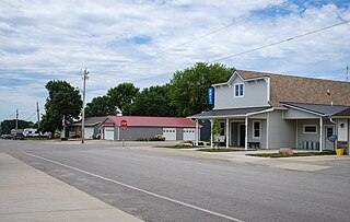
Diagonal is a city in northwest Ringgold County, Iowa, the United States. The population was 344 at the time of the 2020 census.

<span class="mw-page-title-main">Hamburg, Minnesota</span> City in Minnesota, United States

Hamburg is a city in Carver County, Minnesota, United States. The population was 513 at the 2010 census.

<span class="mw-page-title-main">Lake Shore, Minnesota</span> City in Minnesota, United States

Lake Shore is a city in Cass County, Minnesota, United States. The population was 1,056 at the 2020 census. It is part of the Brainerd Micropolitan Statistical Area.

<span class="mw-page-title-main">Erhard, Minnesota</span> City in Minnesota, United States

Erhard is a city in Otter Tail County, Minnesota, United States. The population was 132 at the 2020 census.

<span class="mw-page-title-main">Urbank, Minnesota</span> City in Minnesota, United States

Urbank is a city in Otter Tail County, Minnesota, United States. The population was 52 at the 2020 census.

<span class="mw-page-title-main">Waverly, Missouri</span> City in Missouri, United States

Waverly is a city in Lafayette County, Missouri, and part of the Kansas City metropolitan area within the United States. The population was 849 at the 2010 census.

<span class="mw-page-title-main">Stoutsville, Missouri</span> Village in Missouri, United States

Stoutsville is a village in Monroe County, Missouri, United States. The population was 37 at the 2020 census.

<span class="mw-page-title-main">Federal Dam, Minnesota</span> City in Minnesota, United States

Federal Dam is a city in Cass County, Minnesota, United States, near Leech Lake. The population was 110 at the 2010 census. It is part of the Brainerd Micropolitan Statistical Area.

<span class="mw-page-title-main">Clarkson Valley, Missouri</span> City in Missouri, United States

Clarkson Valley is a city in St. Louis County, Missouri, United States. The population was 2,609 at the 2020 census.

<span class="mw-page-title-main">Kramer, North Dakota</span> City in North Dakota, United States

Kramer is a city in Bottineau County, North Dakota, United States. The population was 24 at the 2020 census. Kramer was founded in 1905.

<span class="mw-page-title-main">Briarwood, North Dakota</span> City in North Dakota, United States

Briarwood is a city in Cass County, North Dakota, United States. The population was 57 at the 2020 census. Briarwood was founded in 1973. It is a suburb directly adjacent to the city of Fargo.

<span class="mw-page-title-main">North River, North Dakota</span> City in North Dakota, United States

North River is a city in Cass County, North Dakota, United States. The population was 55 at the 2020 census. North River was founded in 1973. It is a suburb/bedroom community directly adjacent to the city of Fargo.

<span class="mw-page-title-main">Dunes City, Oregon</span> City in Oregon, United States

Dunes City is a city in Lane County, Oregon, United States. The population was 1,303 at the 2010 census.

<span class="mw-page-title-main">Harrisburg, Oregon</span> City in Oregon, United States

Harrisburg is a city in Linn County, Oregon, United States. The population was 3,567 at the 2010 census.

<span class="mw-page-title-main">Buck Run, Pennsylvania</span> CDP in Pennsylvania, United States

Buck Run is a census-designated place (CDP) in Schuylkill County, Pennsylvania, United States. The population was 176 at the 2010 census.

<span class="mw-page-title-main">Foster Township, Schuylkill County, Pennsylvania</span> Township in Pennsylvania, United States

Foster Township is a township in Schuylkill County, Pennsylvania, United States. The population was 242 at the 2020 census.

<span class="mw-page-title-main">Crooks, South Dakota</span> City in South Dakota, United States

Crooks is a city in Minnehaha County, South Dakota, United States and is a suburb of Sioux Falls. The population was 1,362 at the 2020 census. Crooks was named New Hope until 1904. The town's present name honors W. A. Crooks, a local politician.

<span class="mw-page-title-main">Gilbert, West Virginia</span> Town in West Virginia, United States

Gilbert is a town in Mingo County, West Virginia, United States, along the Guyandotte River. The population was 333 at the 2020 census. Gilbert was incorporated in 1918 and named for Gilbert Creek, which derives its name from the name of an early traveler in the area who was killed by Native Americans. Gilbert is known nationwide for the Hatfield-McCoy ATV Trails that are located in the area. There are a number of lodges and restaurants in Gilbert.

References

  1. "2020 U.S. Gazetteer Files". United States Census Bureau. Retrieved March 16, 2022.
  2. 1 2 U.S. Geological Survey Geographic Names Information System: Buck Grove, Iowa
  3. "Buck Grove IA ZIP Code". zipdatamaps.com. 2024. Retrieved February 5, 2024.
  4. 1 2 "2020 Census State Redistricting Data". census.gov. United states Census Bureau. Retrieved August 12, 2021.
  5. "US Gazetteer files 2010". United States Census Bureau. Archived from the original on July 2, 2012. Retrieved May 11, 2012.
  6. "Census of Population and Housing". Census.gov. Retrieved June 4, 2015.
  7. "U.S. Census website". United States Census Bureau . Retrieved May 11, 2012.
  8. "U.S. Census website". United States Census Bureau . Retrieved January 31, 2008.
  9. "FY20_DENISON" (PDF). Iowa Department of Education. Archived from the original (PDF) on October 20, 2020. Retrieved July 31, 2020.