Buffer strip

Last updated
Contour buffer strips used to retain soil and reduce erosion. Contour buffer strips NRCS.jpg
Contour buffer strips used to retain soil and reduce erosion.

A buffer strip is an area of land maintained in permanent vegetation that helps to control air quality, soil quality, and water quality, along with other environmental problems, dealing primarily on land that is used in agriculture. Buffer strips trap sediment, and enhance filtration of nutrients and pesticides by slowing down surface runoff that could enter the local surface waters. The root systems of the planted vegetation in these buffers hold soil particles together which alleviate the soil of wind erosion and stabilize stream banks providing protection against substantial erosion and landslides. Farmers can also use buffer strips to square up existing crop fields to provide safety for equipment while also farming more efficiently.

Contents

Buffer strips can have several different configurations of vegetation found on them varying from simply grass to combinations of grass, trees, and shrubs. Areas with diverse vegetation provide more protection from nutrient and pesticide flow and at the same time provide better biodiversity amongst plants and animals. [1] [2]

Many country, state, and local governments provide financial incentives for conservation programs such as buffer strips because they help stabilize the environment, help reduce nitrogen emissions to water and soil loss by wind erosion, while simultaneously providing substantial environmental co-benefits, even when the land is being used. [3] Buffer strips not only stabilize the land but can also provide a visual demonstration that land is under stewardship.

Types

Buffers within fields

A grassed waterway reduces soil erosion and captures most nutrients and pesticides that would normally wash out of crop fields and into major waters. These waterways help to carry surface water at a non-erosive velocity to an area where it will have a stable outlet. [1] Outlets must be adequate enough to allow water to drain without ponding or flooding the area being protected, while also preventing erosion of the water into the outlet which can be accomplished through the use of riprap. A limitation is during large runoff events, when soil is saturated, grassed waterways will have a very concentrated flow of water making them not as effective during high rainfalls. Grassed waterways require very little maintenance once they are introduced with major upkeep being mowing of the grass and reseeding. Farm machinery and cattle can cross these waterways but it may be hazardous during wet periods. One of the major disadvantages of waterways are actually getting them established. A late summer or early fall seeding when rainfall is minimal is recommended to allow the seed to have the best chance at establishing a root system. [4]

Contour buffer strips are strips of perennial vegetation alternated with wider cultivated strips of cropland. This type of buffer strip is most effective when runoff water enters uniformly as sheetflow. [1] They are very adapted to trapping pesticides and reducing rill erosion. These buffers need to be at least 15 feet (4.6 m) wide and make up for 20 to 30 percent of slope of an area. A lot of the time contour buffers can be used as a very inexpensive substitute for terraces. Most of the time a grass is selected that can be harvested during mid-summer. These buffers are not permanent and can be moved up and down hillsides from season to season in order to re-establish vegetation. [1]

Edge of field buffers

Vegetative barriers are narrower buffer strips of hardy, native, perennial grasses or shrubs planted in parallel rows to crops. [5] They are very effective in reducing wind and water erosion which results in sediment trapping and water infiltration. They function in a similar fashion to a contour buffer strip, just much narrower. [1]

'Field borders are bands or strips of perennial vegetation that is found on the edge of a cropland field. Field borders help with runoff only when it flows over the strip. They are very effective in benefiting spraying operations because they allow for extra room between adjacent fields. They also provide room for farming equipment to turn around. Field borders are effective in reducing wind and water erosion and provide great wildlife habitat. [1]

Filter strips are areas of grass or other permanent vegetation that protect riparian areas from sediment runoff, pesticides, pathogens, organics and nutrients. These strips are very important in protecting stream banks and water quality. Filter strips work best when other conservation practices are used in order to drain water in their direction. [1] Filter strips were originally used mostly in agriculture, but now are a common practice in urban areas where water quality has become an increasingly important issue. [6]

A riparian buffer of vegetation lining a farm creek in Story County, Iowa. Riparian buffer on Bear Creek in Story County, Iowa.JPG
A riparian buffer of vegetation lining a farm creek in Story County, Iowa.

Riparian forest buffers are diverse communities of trees, shrubs and native perennial grasses. They are great for providing habitat for wildlife on land and in the water. Taller trees next to the streams help to lower water temperatures with shade which improves aquatic communities. The shrubs and grasses help to slow flooding and the larger trees can sometimes intercept nitrates before they reach the water with their deep roots. [1]

Wind buffers

The main purpose of a windbreak or a shelterbelt is to protect areas from wind causing erosion on the bare soil of croplands. Windbreaks can also serve as an area that separates fields and protects them from spray drift of pesticides. [1]

Wildlife habitat

Buffer strips are very important in helping to provide habitat for many species of wildlife in the open farm lands by causing an edge effect. With much of the land open on farms having an edge allows a safe-haven for animals to move between different ecosystems. Buffers are also helpful in conserving biodiversity especially to that of rare or endangered species through the incorporation of native grasses into their seeding by the landowner. Native grasses are especially important to pheasants, quail, chukar and songbirds because they provide the foods they need as well as the shelter from predators. Since most buffer strip areas have limited disturbance from farming it allows for a shelter to hide year round for many of the species including insects, birds, and mammals. When buffers run into and follow riparian areas along stream beds it is important to have larger vegetation like trees and shrubs that shade the water from the open sun. The water is then able to be cooler allowing for greater fish production and other aquatic plants and other biota to thrive in a less disturbed environment. [7]

This area of vegetation following a body of water is noted as a riparian zone. These buffer areas often incorporate large trees that protect stream banks from excessive erosion and shade aquatic areas. The shade provided by the larger trees reduces water temperatures and light intensity from ultraviolet light. Debris including leaves and branches that fell from trees, often contain aquatic invertebrates important to the structure of the water following the "River Continuum" concept. [8] Since the riparian zones contain a larger variety of plants the overall diversity is much greater as well. With more photosynthesis and higher amounts of available water plant primary production can increase in turn creating more potential food for the wildlife. [9]

Planted vegetation

The USDA shows that grassed waterways of less than 5% slopes for a chosen waterway will greatly reduce velocity of draining water within the land. [10] The Natural Resources Conservation Service (NRCS) offers the use of an online Soil survey to view the area of land to be planted and examine slope and soil drainage. [11] As viewed by the Natural Resources Conservation Service, soil drainage is the number one priority for location of certain grasses. Poorer drainage causes less infiltration of water into the soil as groundwater recharge causing ponding and flooding of surrounding crops. Higher drainage becomes more droughty which hinders the establishment of certain grasses good for waterways. Medium soil drainage becomes the most suitable for planting. Determining exact grasses and seed amounts to plant follows specifications of a local NRCS Field Office Technical Guide and the Contour Buffer practice standard while taking practice on land and regional environmental conditions into consideration. [12]

The NRCS has shown contour strip cropping provides the greatest effectiveness when slopes of the area are within 4-8%. [13] For greater success in lowering the erosion, contour strips on the slopes need to follow the contours of the landscape. Row crops like corn, legumes, or soybeans should alternate strips of small grains or forages to successfully limit erosion and slowing or capturing the runoff of fertilizers and pesticides. Tests from the NRCS have shown that the smaller tighter rooted grasses and hays provide more surface cover to prevent rain and wind erosion while slowing runoff, increasing infiltration, and trapping sediment from the high erosive row crops. [14] Proper planting of the contour crops is important for higher success of erosion control to protect highly fertile topsoil.

See also

Related Research Articles

<span class="mw-page-title-main">Buffer zone</span> Intermediate region, typically between belligerent entities

A buffer zone is a neutral zonal area that lies between two or more bodies of land, usually pertaining to countries. Depending on the type of buffer zone, it may serve to separate regions or conjoin them. Common types of buffer zones are demilitarized zones, border zones and certain restrictive easement zones and green belts. Such zones may be comprised by a sovereign state, forming a buffer state.

Natural Resources Conservation Service (NRCS), formerly known as the Soil Conservation Service (SCS), is an agency of the United States Department of Agriculture (USDA) that provides technical assistance to farmers and other private landowners and managers.

<span class="mw-page-title-main">Windbreak</span> Rows of trees or shrubs planted to provide shelter from the wind

A windbreak (shelterbelt) is a planting usually made up of one or more rows of trees or shrubs planted in such a manner as to provide shelter from the wind and to protect soil from erosion. They are commonly planted in hedgerows around the edges of fields on farms. If designed properly, windbreaks around a home can reduce the cost of heating and cooling and save energy. Windbreaks are also planted to help keep snow from drifting onto roadways or yards. Farmers sometimes use windbreaks to keep snow drifts on farm land that will provide water when the snow melts in the spring. Other benefits include contributing to a microclimate around crops, providing habitat for wildlife, and, in some regions, providing wood if the trees are harvested.

<span class="mw-page-title-main">Nutrient management</span> Management of nutrients in agriculture

Nutrient management is the science and practice directed to link soil, crop, weather, and hydrologic factors with cultural, irrigation, and soil and water conservation practices to achieve optimal nutrient use efficiency, crop yields, crop quality, and economic returns, while reducing off-site transport of nutrients (fertilizer) that may impact the environment. It involves matching a specific field soil, climate, and crop management conditions to rate, source, timing, and place of nutrient application.

<span class="mw-page-title-main">Agroforestry</span> Land use management system

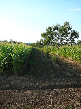
Agroforestry is a land use management system in which combinations of trees or shrubs are grown around or among crops or pastureland. Agroforestry combines agricultural and forestry technologies to create more diverse, productive, profitable, healthy, and sustainable land-use systems. There are many benefits to agroforestry such as increasing farm profitability. In addition, agroforestry helps to preserve and protect natural resources such as controlling soil erosions, creating habitat for the wildlife, and managing animal waste. Benefits also include increased biodiversity, improved soil structure and health, reduced erosion, and carbon sequestration.

<span class="mw-page-title-main">Agricultural wastewater treatment</span> Farm management for controlling pollution from confined animal operations and surface runoff

Agricultural wastewater treatment is a farm management agenda for controlling pollution from confined animal operations and from surface runoff that may be contaminated by chemicals in fertilizer, pesticides, animal slurry, crop residues or irrigation water. Agricultural wastewater treatment is required for continuous confined animal operations like milk and egg production. It may be performed in plants using mechanized treatment units similar to those used for industrial wastewater. Where land is available for ponds, settling basins and facultative lagoons may have lower operational costs for seasonal use conditions from breeding or harvest cycles. Animal slurries are usually treated by containment in anaerobic lagoons before disposal by spray or trickle application to grassland. Constructed wetlands are sometimes used to facilitate treatment of animal wastes.

<span class="mw-page-title-main">Contour plowing</span> Farming practice

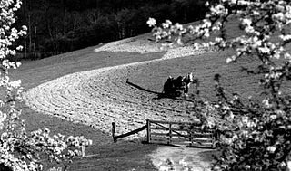
Contour bunding or contour farming or Contour ploughing is the farming practice of plowing and/or planting across a slope following its elevation contour lines. These contour lines create a water break which reduces the formation of rills and gullies during times of heavy precipitation, allowing more time for the water to settle into the soil. In contour plowing, the ruts made by the plow run perpendicular rather than parallel to the slopes, generally furrows that curve around the land and are level. This method is also known for preventing tillage erosion. Tillage erosion is the soil movement and erosion by tilling a given plot of land. A similar practice is contour bunding where stones are placed around the contours of slopes. Contour ploughing has been proved to reduce fertilizer loss, power and time consumption, and wear on machines, as well as to increase crop yields and reduces soil erosion.

<span class="mw-page-title-main">Soil conservation</span> Preservation of soil nutrients

Soil conservation is the prevention of loss of the topmost layer of the soil from erosion or prevention of reduced fertility caused by over usage, acidification, salinization or other chemical soil contamination.

<span class="mw-page-title-main">Strip farming</span>

Strip cropping is a method of farming which involves cultivating a field partitioned into long, narrow strips which are alternated in a crop rotation system. It is used when a slope is too steep or when there is no alternative method of preventing soil erosion. The most common crop choices for strip cropping are closely sown crops such as hay, wheat, or other forages which are alternated with strips of row crops, such as corn, soybeans, cotton, or sugar beets. The forages serve primarily as cover crops. In certain systems, strips in particularly eroded areas are used to grow permanent protective vegetation; in most systems, however, all strips are alternated on an annual basis.

<span class="mw-page-title-main">Living mulch</span> Cover crop grown with a main crop as mulch

In agriculture, a living mulch is a cover crop interplanted or undersown with a main crop, and intended to serve the purposes of a mulch, such as weed suppression and regulation of soil temperature. Living mulches grow for a long time with the main crops, whereas cover crops are incorporated into the soil or killed with herbicides.

<span class="mw-page-title-main">Riparian zone</span> Interface between land and a river or stream

A riparian zone or riparian area is the interface between land and a river or stream. In some regions, the terms riparian woodland, riparian forest, riparian buffer zone,riparian corridor, and riparian strip are used to characterize a riparian zone. The word riparian is derived from Latin ripa, meaning "river bank".

<span class="mw-page-title-main">Erosion control</span> Practice of preventing soil erosion in agriculture and land development

Erosion control is the practice of preventing or controlling wind or water erosion in agriculture, land development, coastal areas, river banks and construction. Effective erosion controls handle surface runoff and are important techniques in preventing water pollution, soil loss, wildlife habitat loss and human property loss.

<span class="mw-page-title-main">Nonpoint source pollution</span> Pollution resulting from multiple sources

Nonpoint source (NPS) pollution refers to diffuse contamination of water or air that does not originate from a single discrete source. This type of pollution is often the cumulative effect of small amounts of contaminants gathered from a large area. It is in contrast to point source pollution which results from a single source. Nonpoint source pollution generally results from land runoff, precipitation, atmospheric deposition, drainage, seepage, or hydrological modification where tracing pollution back to a single source is difficult. Nonpoint source water pollution affects a water body from sources such as polluted runoff from agricultural areas draining into a river, or wind-borne debris blowing out to sea. Nonpoint source air pollution affects air quality, from sources such as smokestacks or car tailpipes. Although these pollutants have originated from a point source, the long-range transport ability and multiple sources of the pollutant make it a nonpoint source of pollution; if the discharges were to occur to a body of water or into the atmosphere at a single location, the pollution would be single-point.

<span class="mw-page-title-main">Conservation Reserve Program</span> U.S. federal aid program

The Conservation Reserve Program (CRP) is a cost-share and rental payment program of the United States Department of Agriculture (USDA). Under the program, the government pays farmers to take certain agriculturally used croplands out of production and convert them to vegetative cover, such as cultivated or native bunchgrasses and grasslands, wildlife and pollinators food and shelter plantings, windbreak and shade trees, filter and buffer strips, grassed waterways, and riparian buffers. The purpose of the program is to reduce land erosion, improve water quality and effect wildlife benefits.

<span class="mw-page-title-main">Revegetation</span>

Revegetation is the process of replanting and rebuilding the soil of disturbed land. This may be a natural process produced by plant colonization and succession, manmade rewilding projects, accelerated process designed to repair damage to a landscape due to wildfire, mining, flood, or other cause. Originally the process was simply one of applying seed and fertilizer to disturbed lands, usually grasses or clover. The fibrous root network of grasses is useful for short-term erosion control, particularly on sloping ground. Establishing long-term plant communities requires forethought as to appropriate species for the climate, size of stock required, and impact of replanted vegetation on local fauna. The motivations behind revegetation are diverse, answering needs that are both technical and aesthetic, but it is usually erosion prevention that is the primary reason. Revegetation helps prevent soil erosion, enhances the ability of the soil to absorb more water in significant rain events, and in conjunction reduces turbidity dramatically in adjoining bodies of water. Revegetation also aids protection of engineered grades and other earthworks.

<span class="mw-page-title-main">Riparian buffer</span> Vegetated area near a stream, usually forested

A riparian buffer or stream buffer is a vegetated area near a stream, usually forested, which helps shade and partially protect the stream from the impact of adjacent land uses. It plays a key role in increasing water quality in associated streams, rivers, and lakes, thus providing environmental benefits. With the decline of many aquatic ecosystems due to agriculture, riparian buffers have become a very common conservation practice aimed at increasing water quality and reducing pollution.

<span class="mw-page-title-main">Grassed waterway</span>

A grassed waterway is a 2-metre (6.6 ft) to 48-metre-wide native grassland strip of green belt. It is generally installed in the thalweg, the deepest continuous line along a valley or watercourse, of a cultivated dry valley in order to control erosion. A study carried out on a grassed waterway during 8 years in Bavaria showed that it can lead to several other types of positive impacts, e.g. on biodiversity.

<span class="mw-page-title-main">Filter strip</span>

Filter strips, also referred to as buffer strips, are small, edge-of-field tracts of vegetated land that are used to reduce the contamination of surface water. They are primarily used in agriculture to control non-point source pollution, however, they may also be used to reduce sediment in storm water runoff from construction sites. There are several types of filter strips including vegetative filter strips, forested riparian buffers, and wind buffers. In agriculture, they are highly effective in reducing the concentration of nitrogen (N) and phosphorus (P) in runoff into surface water and are also effective in reducing sediment erosion and removing pesticides. This helps to prevent eutrophication and associated fishkills and loss of biodiversity. The use of filter strips is very common in developed countries and is required by law in some areas. The implementation and maintenance of filter strips is inexpensive and their use has been shown to be cost effective.

<span class="mw-page-title-main">Mississippi River Watershed Conservation Programs</span>

Conservation programs for the Mississippi River watershed have been designed to protect and preserve it by implementing practices that decrease the harmful effects of development on habitats and to overlook monitoring that helps future planning and management. A main focus is nutrient pollution from agricultural runoff of the nation's soybean, corn and food animal production, and problems relating to sediment and toxins. Conservation programs work with local farmers and producers to decrease excess nutrients because they cause major water quality problems along with hypoxia and loss of habitat. Organizations such as the Mississippi River/Gulf of Mexico Watershed Nutrient Task Force and USDA programs such as the Upper Mississippi River Forestry Partnership and the Mississippi River Basin Healthy Watersheds Initiative contribute to conserving what is left of the Mississippi River watershed.

Prairie strips are strips of native perennial vegetation that are strategically integrated into row crop fields. This technique is used in conservation farming to improve biodiversity, and protect soil and water.

References

  1. 1 2 3 4 5 6 7 8 9 U.S. Natural Resources Conservation Service (NRCS), (2000). "Conservation Buffers to Reduce Pesticide Losses." March 2000.
  2. Woodstock Conservation Commission (2000). Buffer Strips- Common Sense Conservation. Archived 2019-10-25 at the Wayback Machine Town of Woodstock, CT. Retrieved 2009-05-24.
  3. Englund, Oskar; Börjesson, Pål; Mola-Yudego, Blas; Berndes, Göran; Dimitriou, Ioannis; Cederberg, Christel; Scarlat, Nicolae (2021). "Strategic deployment of riparian buffers and windbreaks in Europe can co-deliver biomass and environmental benefits". Communications Earth & Environment. 2 (1): 176. Bibcode:2021ComEE...2..176E. doi: 10.1038/s43247-021-00247-y . S2CID   237310600.
  4. Stone, R. (1994). "Fact Sheet: Grassed Waterways." Archived August 7, 2007, at the Wayback Machine Ontario Ministry of Agriculture, Food and Rural Affairs. Order No. 94-039.
  5. Sharma, K.D. et al. (1999). "Study on the performance of contour vegetative barriers in an arid region using numerical models." [ dead link ]Agricultural Water Management, 41:1, June 1999. doi : 10.1016/S0378-3774(98)00114-0.
  6. Center for Watershed Protection (1997). "Stormwater Management Fact Sheet: Grassed Filter Strip." Stormwater Manager's Resource Center. Ellicott City, MD. Retrieved 2009-05-24.
  7. "revision5_11-7-07_buffer strips.indd" (PDF). Retrieved 2018-07-15.
  8. "Data" (PDF). www.rivercontinuum.org.
  9. "Riparian zone". Eoearth.org. Retrieved 2012-06-26.
  10. ftp://ftp-fc.sc.egov.usda.gov/WSI/UrbanBMPs/water/erosion/grassedwtrway.pdf%5B%5D
  11. "Web Soil Survey - Home". Websoilsurvey.nrcs.usda.gov. 2012-02-17. Retrieved 2012-06-26.
  12. "Info" (PDF). www.plant-materials.nrcs.usda.gov.
  13. "Archived copy" (PDF). Archived from the original (PDF) on 2011-07-25. Retrieved 2010-02-07.{{cite web}}: CS1 maint: archived copy as title (link)
  14. "Contour Stripcropping | Oregon NRCS". Or.nrcs.usda.gov. Archived from the original on 2012-02-20. Retrieved 2012-06-26.