Burngreave

Last updated

Burngreave
Sheffield outline map with UK.svg
Red pog.svg
Burngreave
Location within Sheffield
Population27,481 (Ward. 2011)
OS grid reference SK363884
Metropolitan borough
Metropolitan county
Region
Country England
Sovereign state United Kingdom
Post town SHEFFIELD
Postcode district S3, S4
Dialling code 0114
Police South Yorkshire
Fire South Yorkshire
Ambulance Yorkshire
UK Parliament
List of places
UK
England
Yorkshire
53°23′28″N1°27′11″W / 53.391°N 1.453°W / 53.391; -1.453

Burngreave is an inner city district of Sheffield, South Yorkshire, England lying north of the city centre. The population of the ward taken at the 2011 census was 27,481. [1] It started to develop in the second half of the 19th century. Prior to this, this area was mostly covered by Burnt Greave wood. Most of the area of the wood is covered by Burngreave Cemetery which was built in 1860 (consecrated 1861) and extended in the early 1900s. [2] Grimesthorpe Lane, which runs through Burngreave, is a very old road that follows the course of the Roman Rig, a man-made defensive ridgeprobably built by the Celtic Brigantes tribethat used to run from near the Wicker to Mexborough.

Contents

History

Prehistory

Although there is not much physical evidence of early settlement in Burngreave, we do know that an Iron Age fort was discovered in Roe Woods. [3] The people who built this may have been from a Celtic tribe, the Brigantes. In the early 20th century you could still see the circular banks of the fort they had built. In 1922, however, it was destroyed to build a sports ground (now owned by Sheffield United FC).

Roman period

There is very little evidence of the Roman presence in Burngreave. A hoard of 13 coins was found in Pitsmoor in 1906. [4]

Middle Ages

Around the mid 9th century the north of England fell under Danish control. Several local place names suggest Viking settlement in the area. Osgathorpe (an old Danish name) means the farm belonging to Osga and Grimesthorpe means Grims outlying farm. From this we can imagine that the area was occupied by a farming community at a time when Sheffield was still a small, insignificant place. The name of Roe Wood may possibly[ clarification needed ] be derived from the old Norse word ra meaning rowan tree.[ citation needed ]

The White House on Andover Street, formerly a fish and chip shop White House, Burngreave.jpg
The White House on Andover Street, formerly a fish and chip shop

In the 12th century, a local lord of the manor founded a hospital in the area, called St Leonards. Although there is no trace of it remaining, the name has been passed on to streets in the vicinity, called Spital Hill and Spital Lane (as in hospital).

In the 13th century, a Norman family called De Mounteney were prominent in the area and owned land around Shirecliffe and Grimesthorpe.

Early Modern period

In the 15th century and 16th century, Burngreave was an area of open countryside with scattered farms, fields and woodland. The name Burngreave was first recorded in 1440 as Byron Greve, meaning Bryons Wood. This is shown in early maps on the site currently occupied by Burngreave Cemetery and along Burngreave Road. During the Tudor period Sheffield began to grow but Burngreave remained on the outskirts. Looking back from the top of Pitsmoor at that time, you would have seen rolling hills and farmland leading down to Lady's Bridge where a cluster of shops and houses had developed around the market place next to Sheffield Castle.

Urbanisation and population growth

Burngreave Cemetery chapels Cemetery Chapels At Burngreave Cemetery.jpg
Burngreave Cemetery chapels

During the 18th century and 19th century the area remained still largely rural but industry was beginning to have an impact. In the 1820s the town of Sheffield stopped at the Wicker, below Spital Hill. Pitsmoor was just a hamlet through which the main turnpike road ran from Sheffield to Barnsley and Wakefield. Industry in the area was mostly in the form of small workshops, attached to farm buildings, producing knives and tools for a local market. There were no factories as yet. Maps from the 1830s and 40s show farmsteads, fields, some woodland and a few scattered mansions that belonged to the wealthy elite of Sheffield. At this time Burngreave was considered a highly desirable place for rich families to build new homes in. Mansions such as Osgathorpe House and Firs Hill (both now demolished)[ when? ] were built during this period.

By 1870 a dramatic transformation had taken place. The arrival of heavy steel and engineering industries, concentrated in the Don Valley, created jobs for migrant workers from all over England and as far away as Ireland. Development of the railways and roads also contributed to the expansion of Sheffield as a centre for craftsmanship and industry.

View across typical Burngreave terraced housing to Pye Bank School Pye Bank School (former), from Andover Street, Burngreave, Sheffield - geograph.org.uk - 1762639.jpg
View across typical Burngreave terraced housing to Pye Bank School

Between 1820 and 1860 the population of Sheffield tripled from just over 65,000 to 185,000.[ citation needed ] In Burngreave many new houses including a group of cottages built by William Pass and occupied by miners called Pass-houses (now this location is called Passhouses Road), [5] to accommodate the workforce of nearby industries. These were often terraced or constructed around courts and changed the character of the area completely. Neighbourhoods such as Ellesmere and Woodside became established. In the 1870s the writer Alfred Gatty described the view from Osgathorpe down into the Don Valley: “….there stands, as it were, Dante's city of Dis…masses of buildings, from the tops of which issue fire, and smoke, and steam, which cloud the whole scene, however bright the sunshine.” A drawing from 1879 of John Sorbys Spital Hill steel works captures this atmosphere completely.[ citation needed ]

Despite this grim picture of development, the higher part of Burngreave was far enough away from the noise and pollution to remain popular with Sheffield's industrialists and professional classes. Abbeyfield House was built during the late 19th century by William Pass as his own residence. Originally called Pitsmoor Abbey, it first belonged to William Pass, the owner of a local colliery, then the house was bought by a solicitor, Bernard Wake, who turned it into the family home. He altered the house greatly, adding a sundial, conservatory, greenhouses, a tennis court and outhouses. The gardens were redesigned and a boating lake created around 1883. In the early 20th century Abbeyfield House was occupied by the Greenwood family and then into the possession of the Sheffield Parks Department Training Centre. [5]

Burngreave Vestry Hall Vestry Hall, Burngreave - geograph.org.uk - 1559106.jpg
Burngreave Vestry Hall

By the late 19th century much of the former countryside of Burngreave was covered in houses. Along with these were created the Vestry Hall in 1864 to administer civic functions. Schools, churches, pubs and allotments were also created in the 19th century. The first school, Pitsmoor Village School, was opened in 1836.[ citation needed ] In 1861 Burngreave cemetery was laid out to accommodate the overflow from local church yards as these were full. [6] A cinema and public baths were built in the early 20th century.[ citation needed ] By this time, Burngreave was a suburb of Sheffield, still prosperous and considered a pleasant place to live. It did, however, have an interesting mix of wealthy and working class residents. Occasional declines in the fortunes of the cutlery trade resulted in periods of unemployment and great hardship for many poorer families in the area. A cartoon from a newspaper in 1879 shows a soup kitchen operating from the Vestry Hall, turning away barefoot and hungry children.[ citation needed ]

The World Wars

Burngreave was badly affected by both World Wars. Zeppelin raids killed people and damaged homes in 1916. Again, in 1940, the area was heavily bombed causing much damage to homes and businesses in the area as well as killing and injuring people. In both wars men volunteered or were sent off as conscripts to fight and their places taken in the factories by women. During the Second World War children were evacuated to the countryside and those who stayed behind went to school in peoples' homes as it was considered too risky to operate schools normally.

Since 1945

Housing on Pye Bank road, dating from the 1970s 'New Style' Terraced Houses, Pye Bank Road, Woodside, Sheffield - geograph.org.uk - 1756469.jpg
Housing on Pye Bank road, dating from the 1970s

After the Second World War housing renewal had a major impact on the area. Slum clearance started in earnest and whole neighbourhoods were decanted to other parts of the city whilst the old substandard housing was demolished. In place of the back-to-backs and terraces came new estates of council housing and flats. This changed the character of the area quite dramatically and resulted in many people moving away, never to return. The disruption that many people experienced at this time also affected the sense of community and identity of the area.

In the years immediately after the Second World War, there was a desperate need for labour in Sheffield to rebuild the city and its industries. Around this time Burngreave became home to many new immigrants, arriving from the Caribbean, Pakistan and Yemen. Many found jobs in the steel industry and the hospitals in Sheffield. Later they brought their families to join them and became part of the local community. This was the beginnings of the multicultural community that is Burngreave today. We do know, however, that Asian people had lived in the area even before this period. In Burngreave cemetery there is a grave of an Indian man killed in a colliery accident in Beighton in 1923, called Sultan Mohomed.

Since the 1990s the area has also become home to people from Chile, Somalia, Eritrea, Iraq, Sudan, and several other countries. More recently,[ when? ] Romani people from Slovakia have been settled there. The arrival of people from so many different backgrounds has made Burngreave one of the most ethnically diverse neighbourhoods in Sheffield. A number of different languages are spoken locally and a variety of food on offer in local restaurants and shops.

The industrial decline of the 1980s and 90s in South Yorkshire has taken its toll on Burngreave. High levels of unemployment resulted in poverty once again and a general decline in the appearance of the area. However Burngreave is now[ when? ] experiencing a change in fortune. This has partly resulted from the determination of local residents to stop the spiral of decay and bring about changes.[ citation needed ] In addition a huge government funded regeneration programme, Burngreave New Deal for Communities, was initiated to bring prosperity back to the area, with improvements to houses and green spaces locally[ citation needed ]. New shops have opened recently[ when? ] to serve the needs of different ethnic communities. In late 2011, a Tesco Extra opened on Saville Street, a couple of hundred yards from Spital Hill, the traditional shopping hotspot of the area.[ citation needed ]

In 2013 and 2014 there was unrest between Slovak Roma and Yemeni residents in the Page Hall area. [7]

Transport

Bus routes 97 and 98 link Burngreave to Sheffield City Centre.

Related Research Articles

Attercliffe is an industrial suburb of northeast Sheffield, England on the south bank of the River Don. The suburb falls in the Darnall ward of Sheffield City Council.

<span class="mw-page-title-main">Spitalfields</span> Area of London

Spitalfields is a district in the East End of London and within the London Borough of Tower Hamlets. The area is formed around Commercial Street and includes the locale around Brick Lane, Christ Church, Toynbee Hall and Commercial Tavern. It has several markets, including Spitalfields Market, the historic Old Spitalfields Market, Brick Lane Market and Petticoat Lane Market. It was part of the ancient parish of Stepney in the county of Middlesex and was split off as a separate parish in 1729. Just outside the City of London, the parish became part of the Metropolitan Board of Works area in 1855 as part of the Whitechapel District. It formed part of the County of London from 1889 and was part of the Metropolitan Borough of Stepney from 1900. It was abolished as a civil parish in 1921.

<span class="mw-page-title-main">Dronfield</span> Human settlement in England

Dronfield is a town in North East Derbyshire, England, which includes Dronfield Woodhouse and Coal Aston. It lies in the valley of the River Drone between Chesterfield and Sheffield. The Peak District National Park is three miles (4.8 km) to the west. The name comes from the Old English Dranfleld, probably meaning an open land infested with drone bees.

<span class="mw-page-title-main">Broomhill and Sharrow Vale</span> Electoral ward in the City of Sheffield, South Yorkshire, England

Broomhill and Sharrow Vale — which includes the districts of Broomhill, Broomhall, Crookesmoor, Endcliffe, Sharrow Vale and Tapton Hill — is one of the 28 electoral wards in City of Sheffield, England. The ward was created following the 2015 local government boundary review out of parts of the old Broomhill, Central and Nether Edge wards. It is located in the western part of the city. The population of the Broomhill ward in 2011 was 16,966 people in 5,708 households, covering an area of 2.7 km2. Broomhill & Sharrow Vale is one of the wards that make up the Sheffield Central Parliamentary Constituency.

<span class="mw-page-title-main">Nether Edge and Sharrow (ward)</span> Electoral ward in the City of Sheffield, South Yorkshire, England

<span class="mw-page-title-main">Beeston, Leeds</span> Suburb of Leeds, West Yorkshire, England

Beeston is a suburb of Leeds, West Yorkshire, England located on a hill about 2 miles (3 km) south of the city centre.

Crosspool is a suburb of the City of Sheffield, South Yorkshire, England, located 2.5 miles (4 km) west of the city centre. The suburb falls within the Crookes ward of the City of Sheffield. It is a middle class residential area in an elevated position above the Porter and Rivelin valleys and stands at around 660 feet (200 m) above sea level. Crosspool is situated on the A57 road and is the last suburb on that road before the city boundary and open countryside is reached. In 2011 Crosspool had a population of 6,703.

<span class="mw-page-title-main">Farnley, Leeds</span> District of Leeds, West Yorkshire, England

Farnley is a district in Leeds, West Yorkshire, England, 2 miles (3.2 km) south-west of Leeds city centre, between Wortley, Bramley and the countryside around Pudsey and Gildersome, in the LS12 Leeds postcode area. It is part of the Leeds City Ward Farnley and Wortley with a population of 24,213 according to the 2011 Census. New Farnley is a nearby commuter village.

<span class="mw-page-title-main">Whirlow</span> Suburb of Sheffield, South Yorkshire, England

Whirlow is a suburb of the City of Sheffield in England, it lies 3.7 miles (6 km) south-west of the city centre. The suburb falls within the Dore and Totley ward of the City. It is one of the most affluent areas of Sheffield, with much high class housing and several notable small country houses within it. During the Victorian era it was home to some of Sheffield's most influential citizens. Whirlow straddles the A625, the main Sheffield to Hathersage road. The suburb covers the area from Parkhead in the north to Whirlow Bridge in the south and from Ecclesall Woods in the east to Broad Elms Lane in the west. Whirlow had a population of 1,663 in 2011.

<span class="mw-page-title-main">Areas of Sheffield</span>

The areas of Sheffield, a city and metropolitan borough in the north of England, vary widely in size and history. Some of the areas developed from villages or hamlets, that were absorbed into Sheffield as the city grew, and thus their centres are well defined, but the boundaries of many areas are ambiguous. The areas of Sheffield do not play a significant administrative role, but the city is divided into 28 electoral wards for local elections and 6 parliamentary constituencies for national elections.

<span class="mw-page-title-main">Burngreave (ward)</span> Electoral ward in the City of Sheffield, South Yorkshire, England

<span class="mw-page-title-main">Pitsmoor</span> Human settlement in England

Pitsmoor is a former village, now a suburb of Sheffield, England. The name derives from Or-pits as, anciently, the main local industry was the mining of ore. The village falls within the Burngreave ward of the City.

<span class="mw-page-title-main">Warsash</span> Village in southern Hampshire, England

Warsash is a village in southern Hampshire, England, situated at the mouth of the River Hamble, west of the area known as Locks Heath and south of Sarisbury. Boating plays an important part in the village's economy, and the village has a sailing club. It is also home to the Warsash Maritime Academy, part of Southampton Solent University, which provides training for Merchant Navy Officers from around the world.

<span class="mw-page-title-main">Abbeyfield Park</span>

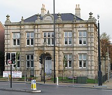
Abbeyfield is a park in Pitsmoor, Sheffield, South Yorkshire, England, bought by the City Corporation in 1909. The park comprises the park itself, a bowling green, as well as Abbeyfield House, a former secondary school. Abbeyfield School opened in 1919 and was the first school to be built outside Sheffield city centre as a result of the 1902 Act. The number of pupils was high and the school soon proved to be too small, children being split in numerous classes in several neighbouring churches. Brush House was converted into a school and some classes moved to that location. Abbeyfield House closed in September 1927 and all pupils moved to Brushes, then called Firth Park Secondary School.

<span class="mw-page-title-main">Demography of Sheffield</span>

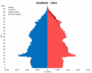
The latest (2021) population estimate for the City of Sheffield is 556,521 residents. This represents an increase of about 17,000 people since the last census in 2011.

<span class="mw-page-title-main">Clapton Pond</span>

Clapton Pond is a pond and garden at Clapton in the London Borough of Hackney.

Walkley is a suburb of Sheffield, England, west of Burngreave, south of Hillsborough and north-east of Crookes.

Netherthorpe is a suburb of the City of Sheffield in England. It is one mile (1.6 km) west of the city centre. It is mostly an area of local government built housing situated on a considerable slope running downhill from the Brook Hill roundabout, at a height of 350 feet (107m), towards the Shalesmoor roundabout at a height of 160 feet (50m) over a distance of half a mile (1 km). It is bounded by the suburbs of Upperthorpe to the north, Crookesmoor to the west and the dualled Inner Ring Road to the east. The suburb falls within the Walkley ward of the City.

<span class="mw-page-title-main">Christ Church, Pitsmoor</span>

Christ Church is an Anglican church in the Pitsmoor district, north of Sheffield City Centre in England. It is a Grade II listed building.

<span class="mw-page-title-main">St Thomas, Brightside</span>

St Thomas is a former Anglican church in the Brightside area of Sheffield in England which now serves as a circus training school.

References

  1. "City of Sheffield ward population 2011". Neighbourhood Statistics. Office for National Statistics. Retrieved 10 March 2016.
  2. Historic England. "BURNGREAVE CEMETERY (Grade II) (1001603)". National Heritage List for England . Retrieved 21 December 2016.
  3. "Retro: Home for the rich and poor". www.thestar.co.uk. 15 December 2015. Retrieved 9 January 2018.
  4. Walford, Edward; Cox, John Charles; Apperson, George Latimer (1906). "Notes of the Month". The Antiquary. E. Stock. XLII (November): 406. Retrieved 20 December 2008.
  5. 1 2 J. Edward Vickers, Old Sheffield Town, 1978, page 27
  6. "Home page". Friends of Burngreave Chapel & Cemetery. Retrieved 21 December 2016.
  7. "Two arrests over mass brawl on Sheffield street". The Star. 21 May 2014. Retrieved 28 January 2015.