
Nether Stowey is a large village in the Sedgemoor district of Somerset, South West England. It sits in the foothills of the Quantock Hills, just below Over Stowey. The parish of Nether Stowey covers approximately 4 km², with a population of 1,373.

Wraxall is a village in North Somerset, England, about 6 miles (10 km) west of Bristol. Until 1811 the parish of the same name also included Nailsea and Flax Bourton. The village is now within the parish of Wraxall and Failand.

Bletchingley is a village in Surrey, England. It is on the A25 road to the east of Redhill and to the west of Godstone, has a conservation area with medieval buildings and is mostly on a wide escarpment of the Greensand Ridge, which is followed by the Greensand Way.
Ogle is a village in and former civil parish, now in the parish of Whalton, Northumberland, England, north-west of Ponteland and south-west of Morpeth. The surname Ogle comes from here, where the Ogle family built Ogle Castle and owned Kirkley Hall. In 1951 the parish had a population of 122.

Coupland Castle is situated in the village of Coupland, 4 miles (6 km) to the north-west of Wooler, Northumberland, England. It is a Grade I listed building. The Grade I listed "castle" is actually a tower house "built after 1584, with irregular later additions".

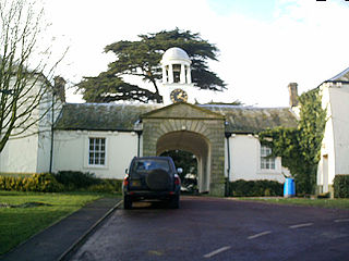
Kirkley Hall is a 17th-century historic country mansion and Grade II listed building in Northumberland, England. The estate is over 190 acres (0.77 km2) and adjoins the River Blyth at Kirkley, three miles north of Ponteland in the heart of the Northumberland countryside, which is now a Horticultural and Agricultural training centre.
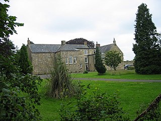
Causey Park House is a 16th-century former manor house with Grade II listed building status situated at Causey Park, Northumberland, England. The Manors of Ogle, and Causey Park and Bothal were merged by the marriage of Robert Ogle and Ellen Bertram in the 14th century.
The Ogle family were prominent landed gentry in Northumberland, England. The earliest appearances of the family name were written Hoggel, Oggehill, Ogille and Oghill.

Lowick is a village in Northumberland, north east England. Lowick lies on the B6353 road, about 10 miles (16 km) south of Berwick-upon-Tweed. The Anglican St John the Baptist's Parish Church dates from 1794, but a chapel was built in the 12th century by monks of Lindisfarne. The Grade II* listed Barmoor Castle, a castellated Tudor style country house is about a mile to the west of the village.

Holton-le-Clay is a village, civil parish and electoral ward in the East Lindsey district of Lincolnshire, England, around 5 miles (8.0 km) south of Grimsby. The village is twinned with Sargé-lès-le-Mans, Sarthe, France.
Burradon is a village in Tyne and Wear, England, to the north of Newcastle upon Tyne. It is adjacent to Camperdown and the two villages are closely linked. Camperdown was once known as Hazlerigge.

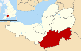
Bath and North East Somerset is a unitary authority created on 1 April 1996, following the abolition of the County of Avon, which had existed since 1974. Part of the ceremonial county of Somerset, Bath and North East Somerset occupies an area of 220 square miles (570 km2), two-thirds of which is green belt. It stretches from the outskirts of Bristol, south into the Mendip Hills and east to the southern Cotswold Hills and Wiltshire border. The city of Bath is the principal settlement in the district, but BANES also covers Keynsham, Midsomer Norton, Radstock and the Chew Valley. The area has a population of 170,000, about half of whom live in Bath, making it 12 times more densely populated than the rest of the area.
Mendip is a local government district in the English county of Somerset. The Mendip district covers a largely rural area of 285 square miles (738 km2) ranging from the Mendip Hills through on to the Somerset Levels. It has a population of approximately 11,000. The administrative centre of the district is Shepton Mallet.
South Somerset is a local government district in the English county of Somerset. The South Somerset district occupies an area of 370 square miles (958 km2), stretching from its borders with Devon and Dorset to the edge of the Somerset Levels. The district has a population of about 158,000, and has Yeovil as its administrative centre.

Rivington in the Borough of Chorley, Lancashire, is situated on the edge of the West Pennine Moors, at the foot of Rivington Pike overlooking reservoirs created for Liverpool Corporation Waterworks in the 19th century. There are twenty eight listed buildings within Rivington, two are classified by English Heritage as Grade II*, the rest as Grade II; Rivington has no Grade I Listed buildings.

Bolton Hall is a country house near Preston-under-Scar, Richmondshire, North Yorkshire, England, in Wensleydale, some 3 miles (5 km) west of Leyburn. It was built in the late 17th century and rebuilt after a fire in 1902. It is a grade II listed building, as is an 18th-century folly tower in the grounds.

The Old Farmhouse is a Grade II* listed pub which was originally a farmhouse, and dates back to at least 1560. It was rebuilt in 1611 and converted to its current usage in 1843. It is claimed to be the oldest building which is now a pub with a beer garden in Southampton, Hampshire. It is situated adjacent to the Mount Pleasant level crossing on the South West Main Line.
Hoghton is a civil parish in the Borough of Chorley, Lancashire, England. It contains 16 buildings that are recorded in the National Heritage List for England as designated listed buildings. Of these, two are listed at Grade I, the highest of the three grades, and the others are at Grade II, the lowest grade. The major building in the parish is Hoghton Tower; this and associated structures are listed. Otherwise the parish in mainly rural, and a number of farmhouses and farm buildings are listed. The other listed buildings consist of two churches, a former school, a war memorial, and a railway viaduct.
Halton-with-Aughton is a civil parish in Lancaster, Lancashire, England. It contains 46 listed buildings that are recorded in the National Heritage List for England. Of these, one is listed at Grade I, the highest of the three grades, three are at Grade II*, the middle grade, and the others are at Grade II, the lowest grade.
Middleton, Lancashire is a civil parish in Lancaster, Lancashire, England. It contains nine listed buildings that are recorded in the National Heritage List for England. All of the listed buildings are designated at Grade II, the lowest of the three grades, which is applied to "buildings of national importance and special interest". The parish contains the village of Middleton, and at one time the Middleton Tower Holiday Camp, which converted some of the existing buildings for its purposes. Otherwise the parish is mainly rural. Most of the listed buildings are, or originated as, houses, farmhouses and associated structures. In addition a folly and a public house are listed.

