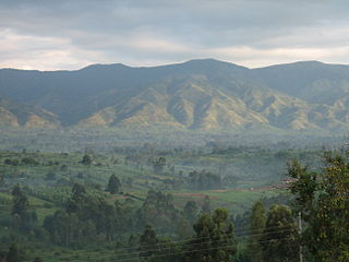
Butembo is 90% populated by the Nande tribe,[3] a community distinguished by ethnic solidarity, conservative moral standards and influential leaders.[4]
Administratively, Butembo has four communes: Bulengera, Kimemi, Mususa and Vulamba. Following various flows of displaced persons fleeing the war, the city has seen its population grow rapidly. It has about two million inhabitants, a 2022 estimate.
The city has 28 quarters (fr quartiers), distributed as follows:
1. Bulengera commune has 9 quarters: Kalemire, Kamesi Mbonzo, Kimbulu, Kyaghala, Mukuna, Mutiri, Rughenda, Wayene and Eveché.
2. Kimemi commune has 8 quarters: Biondi, Bwinyole, Commercial, Lumumba, Malende, Ngerengere, Vutetshe and Vutsundo.
3. Mususa commune has 7 quarters: Bwinongo, Katwa, Kitulu, Matanda, Ngingi, Vigholo and Vungi.
4. Vulamba commune has 4 quarters: Congo Ya Sika, Kambali, Matembe and Mukalangura.
Butembo brings together all twelve Yira (Nande) clans, which is why it is considered the extra-customary capital of this people.[citation needed]
Economy
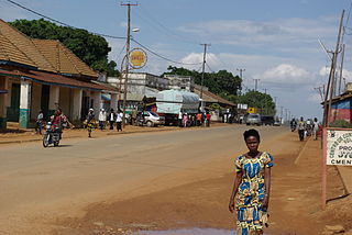
The main activities of its inhabitants are trade, agriculture and livestock. Butembo is built thanks to the dynamism of its inhabitants alone.
Indeed, thanks to the fallout from trade with especially the countries of East Africa, the Middle and the Far East, the city is gradually being endowed with new buildings and charming private residences and it has become the warehouse of goods that supply the cities of Beni (city), Bunia, Kisangani, Goma, Bukavu, Kindu, Isiro, Buta, Bumba, and many others.
The merchants of the city have their own airlines.[citation needed] Butembo has a hundred industries of coffee, cocoa, beverages, sheet metal, tar, candy,...[vague]
Free University of the Great Lakes Region, founded in 2000
Official University of Ruwenzori (UOR)
University of the Assumption in Congo (UAC), founded in 1982
Kasugho University of Nature Conservation and Development (UCNDK)
Higher Pedagogical Institute of Muhangi
Institute of Buildings and Public Works (IBTP)
Higher Institute of Applied Chemistry (ISCA)
Higher Institute of Commerce (ISC BUTEMBO)
High schools
Malkia Wa Mbingu
Kambali Institute (formerly Pie-X)
Agricultural and Veterinary Technical Institute (ITAV)
Monseigneur-Kataliko Institute
Mahamba Industrial Technical Institute
Oriental Mage School Complex
Vulindi Major Seminary
Health
Butembo is home to several major hospitals in northeastern DRC, including:
Katwa General Referral Hospital;
Matanda Hospital;
Caritas Hospital;
Holy Family Hospital in Mukuna;
Vuhimba Hospital;
IRIS medical and surgical center.
History
Before 1924, the village of Lusando served as the residence of the Mwami of the Bayora. It was a center dedicated to the trade of salt from Lake Katwe (Uganda), fish and "milumba", beaten bark cloth, from neighboring regions. From 1928 to 1930, the Compagnie Minière des Grands-Lacs (MGL) set up the administrative headquarters of the northern branch of its operations in Butembo, which became the transit and acclimatization center for the workforce located at road junctions. In the 1930s to 1940s, a core of Europeans composed mainly of traders and industrialists settled 1km south of the MGL headquarters on either side of the Congo-Nile road, the current Route National 2. It is the genesis of an indigenous town between Kambali hill and Ruwenzori avenue.
In the 1943 edition of Codes et Lois du Congo Belge, annotated by Léon Strouvens with Pierre Piron, the name of Butembo was already mentioned in decree no. 47 of August 19, 1937, relating to the urban districts of the province of "Constermansville", future Kivu then fragmented into North Kivu, South Kivu and Maniema. This decree recognizes Butembo as a large village. Subsequently, in 1949 by Order No. 21/053 of September 23, 1949 in accordance with the provisions of Ordinance-Law No. 170/AIMO of July 20, 1945 establishing indigenous cities, Butembo was recognized as an indigenous city.
From 1950 to 1959, Butembo then reached the avenue des écoles, the Congo ya Sika district with respectively 9,653 inhabitants in 1957 and 11,189 inhabitants in 1959. The year 1958 marked the signing of Ordinance No. 97/138 of the May 15, 1956 subjecting Butembo to the regime of the decree of February 21, 1949 relating to town planning. Butembo is therefore recognized as an extra-customary center by Decree No. 221/180 of September 12, 1958. The following decade, the city will extend to Goma Avenue, the Vungi cell, Kimemi, Londo, Muhayirwa and Vihya. With a population of 26,065 inhabitants. In 1962, a law was passed by the assembly of Kivu-Maniema to elevate Butembo to the rank of commune. In 1963, Butembo became the capital of the Lake Edward district. In 1965 was the transfer of the bishopric of the diocese of Beni to Butembo. Repeal of the status of urban commune enjoyed by Butembo following the abolition of the province of North Kivu and the District of Lake Edward in 1967. Butembo was still governed according to the local community system until 1970.
Butembo will then be recognized as a city among the cities created by presidential decrees. The years 1970 to 1979, the city of Butembo is composed of 6 districts named Kambali, Matanda, Vungi, Lumumba, Congo ya Sika and President of the Republic. Later it expands east to Kitulu, Kisingiri, south to Kalimbute, Vutetse, Vulumbi, Vulema and Vuhika. The population then numbered 50,921 in 1975 and 69,227 in 1979. In 1980, Butembo became the residence of a sub-regional deputy commissioner, from where he supervised the administration of the Beni and Lubero zones between 1980 and 1985 In 1987: Butembo is registered on the list of 83 cities recognized and/or created in Zaire by presidential decrees n° 87/231 to 87/238 of 29/6/1987. Around the year 1987 when Butembo had 92,932 inhabitants and the period of the 1990s, a neighboring agglomeration, that of Makerere in the chiefdom-community of Bashu developed while in the chiefdom of Baswagha, the localities of Vohakatwa, Mukuna, Ivatama, Malera, Rughenda, Katsya and Vutsundo are experiencing remarkable population growth, bringing the population to 141,707.
In 1988: Opening of the Catholic University of Graben in Butembo with faculties of human and veterinary medicine, agronomy and economics. In 1993: Inauguration of the first private satellite telecommunications station PATELSAT (telephone, television, fax, etc.).
In 1999: The city of Butembo was granted city status by decree n° 01/001 bis/CAB/GP-MK/99 of September 29, 1999, creating the cities of Beni and Butembo in the provinces of North Kivu, by the rebel authorities of the RCD/K-ML who had chosen Beni as the seat of their political institution during the second so-called war of liberation which broke out on 2 August 1999, in the DRC.
In 2001: The president of the RCD/K-ML the Antipas Mbusa Nyamwisi, son of the region, signed decree No. 2001/038 on December 22 on the creation and delimitation of the city of Butembo and its municipalities in the province of North Kivu.
The President of the Republic Joseph Kabila signed Decree No. 042/2003 of March 28, 2003 recognizing Butembo as a city and setting its boundaries. According to this evolution, it can be seen that Butembo has escaped the application of the planning decrees of 1949 and 1957, which affects its urban fabric.
Ebola
Ebola broke out in August 2018 in North Kivu province. A series of attacks on Ebola treatment centers in Butembo led up to the death of a policeman in March 2019 and of a doctor in April 2019.[9][10] Locals mistakenly believe aid workers brought the virus to the area.[10] More than 102,000 people received an experimental vaccine in this period,[11] but 843 of 1300 confirmed and probable Ebola patients died.[10] Treatment centers were earlier torched in Butembo and Katwa, and medical professionals threatened to strike.[12]
Related Research Articles
North Kivu is a province bordering Lake Kivu in the eastern Democratic Republic of the Congo. Its capital is Goma. The 2020 population was estimated to be 8,147,400.
Goma is the capital and largest city of the North Kivu Province in the eastern region of the Democratic Republic of the Congo (DRC). It is located on the northern shore of Lake Kivu, next to the Rwandan city of Gisenyi. It shares its borders with Bukumu Chiefdom to the north, the Republic of Rwanda to the east, Masisi Territory to the west, and is flanked by Lake Kivu to the south. The city lies in the Albertine Rift, the western branch of the East African Rift System, and lies only 13–18 km (8.1–11.2 mi) south of the active Nyiragongo Volcano. With an approximate area of approximately 75.72 square kilometers, the city has an estimated population of nearly 2 million people according to the 2022 census, while the 1984 estimate placed the number at 80,000.
Banyamulenge is a community from the Democratic Republic of the Congo's South Kivu province. The Banyamulenge are culturally and socially distinct from the Tutsi of North Kivu, with most speaking Kinyamulenge, a mix of Kinyarwanda, Kirundi, Ha language, and Swahili. Banyamulenge are often discriminated against in the DRC due to their Tutsi phenotype, similar to that of people living in the Horn of Africa, their insubordination towards colonial rule, their role in Mobutu's war against and victory over the Simba Rebellion, which was supported by the majority of other tribes in South Kivu, their role during the First Congo War and subsequent regional conflicts (Rally for Congolese Democracy–Goma, Movement for the Liberation of the Congo, National Congress for the Defence of the People, and more importantly for the fact that two of the most influential presidents of their country declared them as enemy of the State both in 1996 and 1998.
Beni is a city in north eastern Democratic Republic of the Congo, lying immediately west of the Virunga National Park and the Rwenzori Mountains, on the edge of the Ituri Forest.
The University of Goma is a public university strategically situated in Goma, within the North Kivu Province of the eastern region of the Democratic Republic of the Congo (DRC). UNIGOM was established in 1993 as the Centre Universitaire du Nord-Kivu (CUNK) and later elevated to university status in 2005. It offers education primarily in French and aims to provide quality education, conduct research, and serve the community. The university's rector is Muhindo Mughanda.
Julien Paluku Kahongya is a Congolese politician. He served as the governor of the province of North Kivu from 27 January 2007 to 22 February 2019.
Masisi Territory is a territory which is located within the North Kivu Province of the Democratic Republic of the Congo. Its political headquarters are located in the town of Masisi.
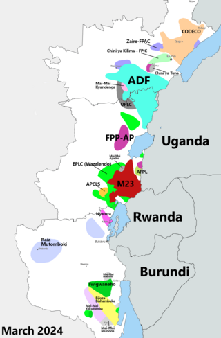
The Kivu conflict is an umbrella term for a series of protracted armed conflicts in the North Kivu and South Kivu provinces in the eastern Democratic Republic of the Congo which have occurred since the end of the Second Congo War. Including neighboring Ituri province, there are more than 120 different armed groups active in the eastern Democratic Republic of Congo. Currently, some of the most active rebel groups include the Allied Democratic Forces, the Cooperative for the Development of the Congo, the March 23 Movement, and many local Mai Mai militias. In addition to rebel groups and the governmental FARDC troops, a number of national and international organizations have intervened militarily in the conflict, including the United Nations force known as MONUSCO, and an East African Community regional force.
Walikale Territory is a territory located within the Congolese province of North Kivu, in the eastern regions of the Democratic Republic of the Congo. The headquarters are in the town of Walikale. The locality is situated between Bukavu and Lubutu on DR Congo National Road No. 3 in the valley of the river Lowa, 135 km to the west of Goma.
Nande (Yira), is a Bantu language also are Bantu population of Central Africa established in the east of the Democratic Republic of Congo in the territories of Beni and Lubero, they constitute more than 60% of the population of the province of North Kivu, they are also in Uganda where they are called Konjo (see Konjo language).
Kanyabayonga is one of the groupements (groupings) within the Bwito Chiefdom in the Rutshuru Territory of North Kivu Province in the eastern Democratic Republic of the Congo (DRC). The region has suffered from continued violence between the army and rival militias since 1993.
The Allied Democratic Forces insurgency is an ongoing conflict waged by the Allied Democratic Forces in Uganda and the Democratic Republic of the Congo, against the governments of those two countries and the MONUSCO. The insurgency began in 1996, intensifying in 2013, resulting in hundreds of deaths. The ADF is known to currently control a number of hidden camps which are home to about 2,000 people; in these camps, the ADF operates as a proto-state with "an internal security service, a prison, health clinics, and an orphanage" as well as schools for boys and girls.
Lubero is a town in the North Kivu Province of the Democratic Republic of the Congo. It is the administrative center of the Lubero Territory. Following the surrender of the Mai-Mai fighters in 2021, construction of a new market began in 2022, involving the mayor, ex-soldiers, "young people at risk and the vulnerable women". As of March 2014, the population of Lubero is not publicly known.
Kasindi is a town in north eastern Democratic Republic of Congo.
The Kivu Ebola epidemic was an outbreak of Ebola virus disease (EVD) mainly in eastern Democratic Republic of the Congo (DRC), and in other parts of Central Africa, from 2018 to 2020. Between 1 August 2018 and 25 June 2020 it resulted in 3,470 reported cases. The Kivu outbreak also affected Ituri Province, whose first case was confirmed on 13 August 2018. In November 2018, the outbreak became the biggest Ebola outbreak in the DRC's history, and had become the second-largest Ebola outbreak in recorded history worldwide, behind only the 2013–2016 Western Africa epidemic. In June 2019, the virus reached Uganda, having infected a 5-year-old Congolese boy who entered Uganda with his family, but was contained.
Busengo is a settlement in the North Kivu Province of the Democratic Republic of the Congo. The town sits across the international border from Busengo, Uganda.
Katwa is a commune of Butembo in North Kivu province, Democratic Republic of Congo, north of Lake Edward and close to the border with Uganda. As of 2012, it had an estimated population of 63,422
Events in the year 2021 in the Republic of the Congo.
The Free University of the Great Lakes Countries, is a private Christian educational institution located in Goma, in the North Kivu Province of the eastern region of the Democratic Republic of the Congo (DRC). ULPGL was founded in 1985, as a result of the Institut Supérieur de Théologie Protestante and was granted university status by the government in 1991. It is sponsored by six Protestant denominations, including two Baptists, two Pentecostals, one Anglican (EAC), and one Methodist (CLMC).
The Fally Ipupa Foundation is a non-profit organization established in 2013 by Congolese singer-songwriter Fally Ipupa. It aims to provide assistance to various marginalized groups in need in the Democratic Republic of the Congo (DRC), including victims of sexual violence, diseases, as well as orphans.
YouTube Video of Nella Star (2007) Video by Godfried van Loo following Dutch sociologist/anthropologist Nella Star when going back to Butembo after over 30 years. With a lot of footage from the city Butembo and surroundings. Dutch/French spoken and subtitled.
This page is based on this Wikipedia article Text is available under the CC BY-SA 4.0 license; additional terms may apply. Images, videos and audio are available under their respective licenses.