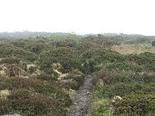

Caer Bran Hill Fort is an archaeological site near Sancreed and Carn Euny Iron Age village, on the Penwith peninsula in Cornwall.
Caer Bran Hill Fort is an archaeological site near Sancreed and Carn Euny Iron Age village, on the Penwith peninsula in Cornwall.
It is a popular location for walkers and antiquarians because it commands a stunning 360 degree panorama of the southern end of the Penwith peninsula, which probably accounts for its defensive importance.
The site consists of an Iron Age hill fort which originally included a circular stone-lined inner wall, twelve feet thick, enclosing a space 200 feet in diameter. Surrounding this was a ditch forty-five feet wide and seven feet deep, an earthen rampart fifteen feet high with stone revetment and a slight counterscarp outer bank. There are remnants of a stone-lined causeway over the ditch at the original entrance to the North West adjacent to the ancient trackway linking Penzance with Land's End. In the centre are the remains of a large circular stone building, of about fifty feet in diameter. [1]
There are three Bronze Age ring cairns within the outer ramparts according to a Cornwall Archaeological Unit Survey. [2] Most of the original stonework was robbed for building purposes during the nineteenth century.
The fort was probably built to protect locally mined metals in particular tin, copper and silver before transportation to nearby ports in Mount's Bay or the Hayle estuary. It overlooked at least three Iron Age settlements within a half mile radius. [3]
The name derives from Caer, the Cornish word for fortress and the name Bran means "Raven" or Crow. The association with Bran probably relates to the nearby hamlet of Brane, a contraction of Bosvran 'the house of Bran'. This may be the same Bran the Blessed from the Mabinogion in Welsh folklore, a giant and King of Britain with parallels to the Fisher King, the keeper of the Holy Grail in Arthurian legend who lived at a castle called Corbenic which is similar to Corben the old French word for Crow. [4]
In Cornish folklore the name Bran is associated with the Mên Scryfa granite pillar which contains the inscription 'rialobrani cunovali fili' which means 'royal raven glorious prince'. An invader attacked the glorious prince and occupied a hill fort, at Penzance driving Bran back to his hill fort at Caer Bran. A battle was fought, and Bran was killed possibly on his way to Chun Castle and a stone was erected at the site which was said to correspond to the height of the dead warrior. [5]
In local legend Caer Bran was said to be a sanctuary from evil spirits and the abode of the Pobel Vean (Cornish: Little people) or faeries. [6]

Chysauster Ancient Village is a late Iron Age and Romano-British village of courtyard houses in Cornwall, England, United Kingdom, which is currently in the care of English Heritage. The village included eight to ten houses, each with its own internal courtyard. To the south east is the remains of a fogou, an underground structure of uncertain function.

A fogou or fougou is an underground, dry-stone structure found on Iron Age or Romano-British-defended settlement sites in Cornwall. The original purpose of a fogou is uncertain today. Colloquially called vugs, vows, foggos, giant holts, or fuggy holes in various dialects, fogous have similarities with souterrains or earth-houses of northern Europe and particularly Scotland, including Orkney. Fewer than 15 confirmed fogous have been found.

Carn Euny is an archaeological site near Sancreed, on the Penwith peninsula in Cornwall, United Kingdom with considerable evidence of both Iron Age and post-Iron Age settlement. Excavations on this site have shown that there was activity at Carn Euny as early as the Neolithic period. There is evidence that shows that the first timber huts there were built about 200 BC, but by the 1st century BC, these had been replaced by stone huts. The remains of these stone huts are still visible today.

Chûn Castle is a large Iron Age hillfort (ringfort) near Penzance in Cornwall, England, United Kingdom. The fort was built about 2,500 years ago, and fell into disuse until the early centuries AD when it was possibly re-occupied to protect the nearby tin mines. It stands beside a prehistoric trackway that was formerly known as the Old St Ives Road and the Tinners’ Way. The name Chûn derives from Cornish: Chi an Woon. The area is now sometimes known as Chûn Downs. Nearby is Chûn Quoit.
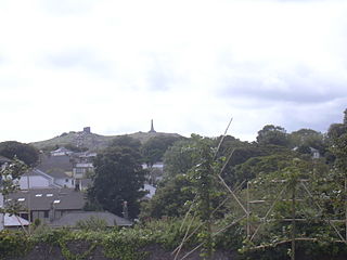
Carn Brea is a civil parish and hilltop site in Cornwall, England, United Kingdom. The population of Carn Brea including Bosleake and Church Coombe was 8,013 at the 2011 census. The hilltop site is situated approximately one mile (1.6 km) southwest of Redruth. The settlements of Bosleake, Brea, Broad Lane, Carn Arthen, Carn Brea Village, Carnkie, Four Lanes, Grillis, Illogan Highway, Pencoys, Penhallick, Piece, Pool, Tolskithy, Tregajorran, Treskillard, Tuckingmill and West Tolgus are in the parish.
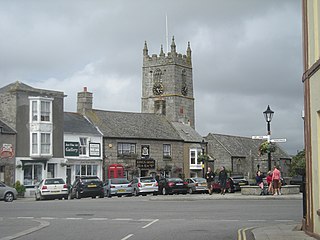
St Just, known as St Just in Penwith, is a town and civil parish in the Penwith district of Cornwall, England, United Kingdom. It lies along the B3306 road which connects St Ives to the A30 road. The parish encompasses the town of St Just and the nearby settlements of Trewellard, Pendeen and Kelynack: it is bounded by the parishes of Morvah to the north-east, Sancreed and Madron to the east, St Buryan and Sennen to the south and by the sea in the west. The parish consists of 7,622 acres (3,085 ha) of land, 12 acres (4.9 ha) of water and 117 acres (47.3 ha) of foreshore. The town of St Just is the most westerly town in mainland Britain and is situated approximately 8 miles (13 km) west of Penzance along the A3071. St Just parish, which includes Pendeen and the surrounding area, has a population of 4,637. An electoral ward of the same name also exists: the population of this ward at the same census was 4,812.

Pendeen is a village and ecclesiastical parish on the Penwith peninsula in Cornwall, England. It is 3 miles north-northeast of St Just and 7 mi (11 km) west of Penzance. It lies along the B3306 road which connects St Ives to Land's End and the A30 road.

Sancreed is a village and civil parish in Cornwall, England, United Kingdom, approximately three miles (5 km) west of Penzance.

William Copeland Borlase was a British antiquarian and Liberal politician who sat in the House of Commons from 1880 until 1887 when he was ruined by bankruptcy and scandal.
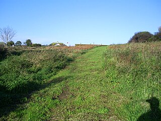
Lescudjack Hill fort is the name given to the unexcavated Iron Age settlement located in Penzance, Cornwall. It is positioned on the summit of a steep hill in the east of Penzance and consists of a single rampart enclosing an area of 3 acres (12,000 m2). The site has been damaged and contains allotments and an open area of land which has recently been cleared of thick undergrowth. It is reported that a small lead-copper mine was situated "just outside" the ramparts, however all trace of this appears to have vanished.
Bosporthennis is a hamlet south of Treen in the civil parish of Zennor on the Penwith peninsula in west Cornwall, England, United Kingdom.
Sancreed Beacon is a Bronze Age archaeological site near the village of Sancreed in the Penwith peninsula of Cornwall maintained by the Cornwall Heritage Trust. On top of the hill are several stone cists and Bronze Age archaeological remains comprising burial mounds and the remains of a Bronze Age hut on the Western slope.

Bartinney Castle is an Iron Age enclosure located in the Penwith Peninsula of Southwest Cornwall, England, it is surrounded by a circular earthwork standing on a hill surrounded by various archaeological prehistoric remains, including ancient settlements, field systems, tumuli and cairns.

Brane is a hamlet southwest of Sancreed in west Cornwall, England, UK. It is in the civil parish of Sancreed. It is noted for the Carn Euny Iron Age site which lies to the north. Other prehistoric sites nearby include the Iron-Age hill fort of Caer Bran, and chambered tomb known as Brane Barrow.

Grumbla is a hamlet in the parish of Sancreed, Cornwall, England, UK.
A plen-an-gwarry or plain-an-gwary, is a "playing-place" or round, a medieval amphitheatre found in Cornwall. A circular outdoor space used for plays, sports, and public events, the plen-an-gwary was a Cornish variant of a construction style found across Great Britain. Formerly common across Cornwall, only two survive nearly complete today: the Plain in St Just in Penwith and Saint Piran's Round near Perranporth.

Cornish promontory forts, commonly known in Cornwall as cliff castles, are coastal equivalents of the hill forts and Cornish "rounds" found on Cornish hilltops and slopes. Similar coastal forts are found on the north–west European seaboard, in Normandy, Brittany and around the coastlines of the British Isles, especially in Wales, Scotland and Ireland. Many are known in southwest England, particularly in Cornwall and its neighbouring county, Devon. Two have been identified immediately west of Cornwall, in the Isles of Scilly.
The Cornwall Heritage Trust (CHT) is an organisation which owns and manages historic sites in Cornwall, England. It was founded in 1985. It works in close cooperation with Natural England, Historic England and English Heritage.
Presented below is an alphabetical index of articles related to Cornwall:

Craig Weatherhill was a Cornish antiquarian, novelist and writer on the history, archaeology, place names and mythology of Cornwall.