
Cumberland is a historic county in North West England that had an administrative function from the 12th century until 1974. It is bordered by the historic counties of Northumberland to the northeast, County Durham to the east, Westmorland to the southeast, Lancashire to the south, and the Scottish counties of Dumfriesshire and Roxburghshire to the north. It formed an administrative county from 1889 to 1974 and now forms part of Cumbria. In April 2023 local government in Cumbria will be reorganised into two unitary authorities, one of which is to be named Cumberland and would include most of the historic county, with the exception of Penrith and the surrounding area.

Radnorshire is a sparsely populated area, one of thirteen historic and former administrative counties of Wales. It is represented by the Radnorshire area of Powys, which according to the 2011 census, had a population of 25,821. The historic county was bounded to the north by Montgomeryshire and Shropshire, to the east by Herefordshire, to the south by Brecknockshire and to the west by Cardiganshire.

Monmouthshire, also known as the County of Monmouth, is one of thirteen historic counties of Wales and a former administrative county. It corresponds approximately to the present principal areas of Monmouthshire, Blaenau Gwent, Newport and Torfaen, and those parts of Caerphilly and Cardiff east of the Rhymney River.
Historic Denbighshire is one of thirteen traditional counties in Wales, a vice-county and a former administrative county, which covers an area in north east Wales. It is a maritime county, bounded to the north by the Irish Sea, to the east by Flintshire, Cheshire and Shropshire, to the south by Montgomeryshire and Merionethshire, and to the west by Caernarfonshire.

The Local Government (Ireland) Act 1898 was an Act of the Parliament of the United Kingdom of Great Britain and Ireland that established a system of local government in Ireland similar to that already created for England, Wales and Scotland by legislation in 1888 and 1889. The Act effectively ended landlord control of local government in Ireland.
In England and Wales, Northern Ireland, and the Republic of Ireland, an urban district was a type of local government district that covered an urbanised area. Urban districts had an elected urban district council (UDC), which shared local government responsibilities with a county council.

Rural districts were a type of local government area – now superseded – established at the end of the 19th century in England, Wales, and Ireland for the administration of predominantly rural areas at a level lower than that of the administrative counties.

In England, a civil parish is a type of administrative parish used for local government. It is a territorial designation which is the lowest tier of local government below districts and counties, or their combined form, the unitary authority. Civil parishes can trace their origin to the ancient system of ecclesiastical parishes which historically played a role in both secular and religious administration; civil and religious parishes were formally differentiated in the 19th century and are now entirely separate. Civil parishes in their modern form came into being through the Local Government Act 1894, which established elected parish councils to take on the secular functions of the parish vestry.

A civil parish is a country subdivision, forming the lowest unit of local government in England. There are 125 civil parishes in the ceremonial county of Bedfordshire, most of the county being parished: Luton is completely unparished; Central Bedfordshire is entirely parished. At the 2001 census, there were 312,301 people living in the 125 parishes, which accounted for 55.2 per cent of the county's population.
Gloucester was, from 1894 to 1974, a rural district in the administrative county of Gloucestershire, England. The district did not include the City of Gloucester, which was a separate county borough. In 1935 Gloucester RD was more than doubled in size.
The Local Government Act 1894 was an Act of the Parliament of the United Kingdom that reformed local government in England and Wales outside the County of London. The Act followed the reforms carried out at county level under the Local Government Act 1888. The 1894 legislation introduced elected councils at district and parish level.
Sanitary districts were established in England and Wales in 1872 and in Ireland in 1878. The districts were of two types, based on existing structures:
Sunbury on Thames Urban District, also known as Sunbury Urban District, was a local government district from 1894 to 1974 comprising the town and parish of Sunbury-on-Thames and from 1930 also the parishes of Littleton and Shepperton.
The Newport district was one of the five local government districts of Gwent from 1974 to 1996. The district comprised the county borough of Newport and several surrounding parishes. It inherited the borough status of the former authority and was therefore styled as the Borough of Newport.
St Mellons Rural District is a defunct district council. It was established under the provisions of the Local Government Act 1894 from part of the existing Newport Rural Sanitary District. It comprised the parishes of Bedwas, Bettws, Coedkernew, Duffryn, Graig, Henllys, Machen Lower, Machen Upper, Malpas, Marshfield, Michaelstone-y-Fedw, Peterstone Wentloog, Rogerstone, Rumney, St Brides Wentloog, St Mellons and St Woolos in the administrative county of Monmouthshire. Initially, the St Mellons Rural District Council also administered two parishes in Glamorgan: Llanvedw and Rhydygwern, which had also formed part of the sanitary district. The Glamorgan parishes were annexed to Llandaff and Dinas Powis Rural District in 1895.
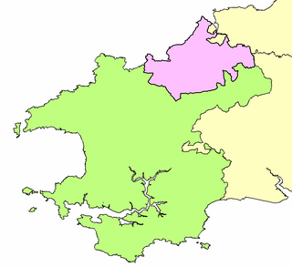
St Dogmells was a rural district in the administrative county of Pembrokeshire, Wales from 1894 to 1934.
The history of local government in Wales in a recognisably modern form emerged during the late 19th century. Administrative counties and county boroughs were first established in Wales in 1889. Urban and rural districts were formed in 1894. These were replaced in 1974 by a two-tier authority system across the country comprising eight counties and, within them, thirty-seven districts. This system was itself replaced by the introduction of 22 single-tier authorities in 1996.

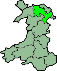
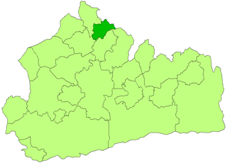
Knighton was, from 1894 to 1974, a rural district in the administrative county of Radnorshire, Wales.
The History of local government districts in Buckinghamshire began in 1835 with the formation of poor law unions. This was followed by the creation of various forms of local government body. In 1894 the existing arrangements were replaced with a system of municipal boroughs, urban and rural districts, which remained in place until 1974.
Chipping Norton Rural District was a rural district in Oxfordshire, England from 1894 to 1974. It surrounded but did not include the town of Chipping Norton.

