California Current

Last updated
Major currents in the California Current System: the California Current (the bulkier, vertical blue line), the coastal jet, the Davidson Current and California Undercurrent, and the Southern California Eddy/Countercurrent. Diagram of California Current System.png
Major currents in the California Current System: the California Current (the bulkier, vertical blue line), the coastal jet, the Davidson Current and California Undercurrent, and the Southern California Eddy/Countercurrent.

The California Current (Spanish : Corriente de California ) is a cold water Pacific Ocean current that moves southward along the western coast of North America, beginning off southern British Columbia and ending off southern Baja California Sur. It is considered an Eastern boundary current due to the influence of the North American coastline on its course. It is also one of six major coastal currents affiliated with strong upwelling zones, the others being the Humboldt Current, the Canary Current, the Benguela Current, the Oyashio Current, and the Somali Current. The California Current is part of the North Pacific Gyre, a large swirling current that occupies the northern basin of the Pacific.

Contents

The related California Current Conservation Complex is a grouping of federally-designated marine protected areas that have been on the UNESCO list of tentative World Heritage Sites since 2017, which includes the following areas found throughout the current: the Point Reyes National Seashore, the Golden Gate National Recreation Area, the Monterey Bay, Greater Farallones and Cordell Bank National Marine Sanctuaries, the Farallon Islands National Wildlife Refuge, and the California Coastal National Monument. [1] [2]

Physical properties

The lack of clouds along the coast (and also along the Central Valley of California) is due to an offshore wind blowing drier air from the land offshore. Corriente de California-Feb-13-2013-20.jpg
The lack of clouds along the coast (and also along the Central Valley of California) is due to an offshore wind blowing drier air from the land offshore.
Upwelling process off the coast of California bringing cooler, nutrient rich water up to the surface. Water temperature off the California coastline.jpg
Upwelling process off the coast of California bringing cooler, nutrient rich water up to the surface.

The movement of Alaskan and northern ocean currents southward down the west coast results in much cooler ocean temperatures than at comparable latitudes on the east coast of the United States, where ocean currents come from the Caribbean and tropical Atlantic. The cooler ocean current along the west coast also makes summer temperatures cooler on the west coast compared to the east coast. For example, Half Moon Bay at 37°N has no month with an average high above 67 °F (19 °C) and San Francisco often stays below 70 °F (21 °C) in summer, while Virginia Beach, VA, close to the same latitude, has high temperatures above 80 °F (27 °C) in summer.

Additionally, extensive upwelling of colder sub-surface waters occurs, caused by the prevailing northwesterly winds acting through the Ekman Effect. The winds drive surface water to the right of the wind flow, that is offshore, which draws water up from below to replace it. The upwelling further cools the already cool California Current. This is the mechanism that produces California's characteristic coastal fog and cool ocean waters. As a result, ocean surf temperatures are much colder along the Pacific coast than the Atlantic coast. For example, the average July SST (sea surface temperature) at New York City at 40.7°N is 73 °F (23 °C), while at the same latitude in Eureka, CA is 57 °F (14 °C). As such, ocean surf temperatures are rarely above 70 °F (21 °C) during the summer along the California south coast, while they are often above 80 °F (27 °C) on the east coast from North Carolina southward. [3]

The cold water is highly productive due to the upwelling, which brings to the surface nutrient-rich sediments, supporting large populations of whales, seabirds and important fisheries. Winds of the appropriate direction and strength to induce upwelling are more prevalent in the presence of Eastern boundary currents, such as the California Current. [3] Phytoplankton production is dramatically increased in these areas because the nutrient-rich water lying below the pycnocline is relatively close to the surface and is thus easily upwelled. [3] Scientists at Scripps Institution of Oceanography said in 2011 that the average surface temperature of the water at Scripps Pier has increased by almost 3 degrees since 1950. [4]

The "Bakun upwelling index" is based on a 20-year average of the monthly mean Ekman transport for different regions off the California coast since the 1970s. It ranges from 300 meters-cubed/second (in the offshore direction) to −212 meters-cubed/second (toward the coast, or onshore direction). There is year-round upwelling off Southern California's coast, but it is strongest in the summer months. Off the coast of Oregon and Washington, there is forceful downwelling in the winter months, and upwelling in the region is restricted to the months of April through September. [5] Other measures have also been proposed for this important seawater system, although some rely on shorter data series. For example, using data series available since 1988, the Coastal Upwelling Transport Index and the Biologically Effective Upwelling Transport Index provide improved estimates of vertical transport and vertical nitrate flux. [6]

Measurements relevant to this current have only been made with instruments since 1946. Prior to this date, the processes, and especially the nutrient status of waters, have to be inferred from historic data sources. One example are the nitrogen isotope ratios in macroalgae. [7] California current is a very wide, cold and strong current. It runs southward down North America.

Biological properties

Primary production is a topic of interest among those who study the California Current. In their study, Hayward and Venrick (1982) found great variability in both biomass and the productivity of phytoplankton in the California Current. The differences observed by Hayward and Venrick in carbon-fixation rates (0.2–2.0 grams carbon/(meter-squared × day)) show the heterogeneous nature of the California Current, with its combination of advected (see advection) and upwelled water. Several studies have investigated the carbon flow from primary production to the pelagic fish stocks which depend on the California Current. Lasker (1988) described powerful "jets and squirts" off northern and central California. These 'jets and squirts' move large quantities of cold, nutrient rich water offshore. This water then gets carried by the southward bound California Current and adds significant primary production to the sardine population. [3]

A narrower, weaker counter current, the Davidson Current, occasionally moves somewhat warmer water northwards during the winter months. During El Niño events, the California Current is disrupted, leading to declines in phytoplankton, resulting in cascading effects up the food chain, such as declines in fisheries, seabird breeding failures and marine mammal mortality (Schwing et al., 2003). In 2005, a failure in the otherwise predictable upwelling events, unassociated with El Niño, caused a collapse in krill in the current, leading to similar effects (Schwing et al., 2003).

Within the Southern California Bight, a sub-region of the California Current has unique physical properties. Upwelling is fairly weak in the California Bight and Smith and Eppley (1982) stated that the 16-year average for primary production was 0.402 grams carbon/(meter-squared × day), or approximately 150 grams carbon/(meter-squared × year). Further, Smith and Eppley (1982) found that the highest daily rates of temperature decrease were correlated with the maximum amount of upwelling. [3] Digiacomo and Holt (2001) used satellite images to study the mesoscale and sub-mesoscale eddies in the Southern California Bight. Their work showed that all eddies were less than 50 kilometres (31 mi) in diameter and 70% of all eddies measured less than 10 kilometres (6.2 mi). [3] The eddies appeared to be caused mostly by topography (particularly islands), wind, and instabilities in the current. These eddies lay mainly between the California Current (flowing toward the equator) and the coastline. [3] The majority of these eddies were cyclonic and had the ability to induce the upwelling of nutrient-rich water. Small scale topographic features such as headlands have been shown to cause substantial effects on the population dynamics of benthic invertebrates, such a change in the settlement patterns of crabs and sea urchin. [3]

In the 2016 Disney/Pixar animated film Finding Dory , the California Current is portrayed as a superhighway that fish and sea turtles use to travel to California. The characters Marlin (Albert Brooks), Nemo (Hayden Rolence), and Dory (Ellen DeGeneres) join Crush (Andrew Stanton), Squirt (Bennett Dammann) and a group of baby and adult sea turtles in using the California Current, to help them travel to Morro Bay, California to find her parents Jenny and Charlie.

Related Research Articles

<span class="mw-page-title-main">Antarctic Circumpolar Current</span> Ocean current that flows clockwise from west to east around Antarctica

The Antarctic Circumpolar Current (ACC) is an ocean current that flows clockwise from west to east around Antarctica. An alternative name for the ACC is the West Wind Drift. The ACC is the dominant circulation feature of the Southern Ocean and has a mean transport estimated at 100–150 Sverdrups, or possibly even higher, making it the largest ocean current. The current is circumpolar due to the lack of any landmass connecting with Antarctica and this keeps warm ocean waters away from Antarctica, enabling that continent to maintain its huge ice sheet.

<span class="mw-page-title-main">Upwelling</span> Replacement by deep water moving upwards of surface water driven offshore by wind

Upwelling is an oceanographic phenomenon that involves wind-driven motion of dense, cooler, and usually nutrient-rich water from deep water towards the ocean surface. It replaces the warmer and usually nutrient-depleted surface water. The nutrient-rich upwelled water stimulates the growth and reproduction of primary producers such as phytoplankton. The biomass of phytoplankton and the presence of cool water in those regions allow upwelling zones to be identified by cool sea surface temperatures (SST) and high concentrations of chlorophyll a.

<span class="mw-page-title-main">Benguela Current</span> Ocean current in the South Atlantic

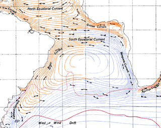
The Benguela Current is the broad, northward flowing ocean current that forms the eastern portion of the South Atlantic Ocean gyre. The current extends from roughly Cape Point in the south, to the position of the Angola-Benguela front in the north, at around 16°S. The current is driven by the prevailing south easterly trade winds. Inshore of the Benguela Current proper, the south easterly winds drive coastal upwelling, forming the Benguela Upwelling System. The cold, nutrient rich waters that upwell from around 200–300 m (656–984 ft) depth in turn fuel high rates of phytoplankton growth, and sustain the productive Benguela ecosystem.

<span class="mw-page-title-main">Humboldt Current</span> Current of the Pacific Ocean

The Humboldt Current, also called the Peru Current, is a cold, low-salinity ocean current that flows north along the western coast of South America. It is an eastern boundary current flowing in the direction of the equator, and extends 500–1,000 km (310–620 mi) offshore. The Humboldt Current is named after the German naturalist Alexander von Humboldt even though it was discovered by José de Acosta 250 years before Humboldt. In 1846, von Humboldt reported measurements of the cold-water current in his book Cosmos.

<span class="mw-page-title-main">Kuroshio Current</span> North flowing ocean current on the west side of the North Pacific Ocean

The Kuroshio Current, also known as the Black or Japan Current or the Black Stream, is a north-flowing, warm ocean current on the west side of the North Pacific Ocean basin. It was named for the deep blue appearance of its waters. Similar to the Gulf Stream in the North Atlantic, the Kuroshio is a powerful western boundary current that transports warm equatorial water poleward and forms the western limb of the North Pacific Subtropical Gyre. Off the East Coast of Japan, it merges with the Oyashio Current to form the North Pacific Current.

<span class="mw-page-title-main">Canary Current</span> Wind-driven surface current that is part of the North Atlantic Gyre

The Canary Current is a wind-driven surface current that is part of the North Atlantic Gyre. This eastern boundary current branches south from the North Atlantic Current and flows southwest about as far as Senegal where it turns west and later joins the Atlantic North Equatorial Current. The current is named after the Canary Islands. The archipelago partially blocks the flow of the Canary Current.

<span class="mw-page-title-main">Pycnocline</span> Layer where the density gradient is greatest within a body of water

A pycnocline is the cline or layer where the density gradient is greatest within a body of water. An ocean current is generated by the forces such as breaking waves, temperature and salinity differences, wind, Coriolis effect, and tides caused by the gravitational pull of celestial bodies. In addition, the physical properties in a pycnocline driven by density gradients also affect the flows and vertical profiles in the ocean. These changes can be connected to the transport of heat, salt, and nutrients through the ocean, and the pycnocline diffusion controls upwelling.

<span class="mw-page-title-main">East Australian Current</span> Currents of the Pacific Ocean

The East Australian Current (EAC) is a warm, southward, western boundary current that is formed from the South Equatorial Current (SEC) crossing the Coral Sea and reaching the eastern coast of Australia. At around 15° S near the Australian coast the SEC divides forming the southward flow of the EAC. It is the largest ocean current close to the shores of Australia.

<span class="mw-page-title-main">Alaska Current</span> Warm-water current flowing nortwards along the coast of British Columbia and the Alaska Panhandle

The Alaska Current is a southwestern shallow warm-water current alongside the west coast of the North American continent beginning at about 48-50°N. The Alaska Current produces large clockwise eddies at two sites: west of the Haida Gwaii and west of Sitka, Alaska.

<span class="mw-page-title-main">Leeuwin Current</span> Ocean current off Western Australia

The Leeuwin Current is a warm ocean current which flows southwards near the western coast of Australia. It rounds Cape Leeuwin to enter the waters south of Australia where its influence extends as far as Tasmania.

<span class="mw-page-title-main">Ekman transport</span> Net transport of surface water perpendicular to wind direction

Ekman transport is part of Ekman motion theory, first investigated in 1902 by Vagn Walfrid Ekman. Winds are the main source of energy for ocean circulation, and Ekman transport is a component of wind-driven ocean current. Ekman transport occurs when ocean surface waters are influenced by the friction force acting on them via the wind. As the wind blows it casts a friction force on the ocean surface that drags the upper 10-100m of the water column with it. However, due to the influence of the Coriolis effect, the ocean water moves at a 90° angle from the direction of the surface wind. The direction of transport is dependent on the hemisphere: in the northern hemisphere, transport occurs at 90° clockwise from wind direction, while in the southern hemisphere it occurs at 90° anticlockwise. This phenomenon was first noted by Fridtjof Nansen, who recorded that ice transport appeared to occur at an angle to the wind direction during his Arctic expedition of the 1890s. Ekman transport has significant impacts on the biogeochemical properties of the world's oceans. This is because it leads to upwelling and downwelling in order to obey mass conservation laws. Mass conservation, in reference to Ekman transfer, requires that any water displaced within an area must be replenished. This can be done by either Ekman suction or Ekman pumping depending on wind patterns.

<span class="mw-page-title-main">Somali Current</span> Ocean boundary current that flows along the coast of Somalia and Oman in the Western Indian Ocean

The Somali Current is a warm ocean boundary current that runs along the coast of Somalia and Oman in the Western Indian Ocean and is analogous to the Gulf Stream in the Atlantic Ocean. This current is heavily influenced by the monsoons and is the only major upwelling system that occurs on a western boundary of an ocean. The water that is upwelled by the current merges with another upwelling system, creating one of the most productive ecosystems in the ocean.

In oceanography, a front is a boundary between two distinct water masses. The formation of fronts depends on multiple physical processes and small differences in these lead to a wide range of front types. They can be as narrow as a few hundreds of metres and as wide as several tens of kilometres. While most fronts form and dissipate relatively quickly, some can persist for long periods of time.

<span class="mw-page-title-main">Great South Australian Coastal Upwelling System</span> Seasonal upwelling system in the eastern Great Australian Bight

The Great South Australian Coastal Upwelling System is a seasonal upwelling system in the eastern Great Australian Bight, extending from Ceduna, South Australia, to Portland, Victoria, over a distance of about 800 kilometres (500 mi). Upwelling events occur in the austral summer when seasonal winds blow from the southeast. These winds blow parallel to the shoreline at certain areas of the coast, which forces coastal waters offshore via Ekman transport and draws up cold, nutrient-rich waters from the ocean floor.

<span class="mw-page-title-main">Haida Eddies</span>

Haida Eddies are episodic, clockwise rotating ocean eddies that form during the winter off the west coast of British Columbia's Haida Gwaii and Alaska's Alexander Archipelago. These eddies are notable for their large size, persistence, and frequent recurrence. Rivers flowing off the North American continent supply the continental shelf in the Hecate Strait with warmer, fresher, and nutrient-enriched water. Haida eddies are formed every winter when this rapid outflow of water through the strait wraps around Cape St. James at the southern tip of Haida Gwaii, and meets with the cooler waters of the Alaska Current. This forms a series of plumes which can merge into large eddies that are shed into the northeast Pacific Ocean by late winter, and may persist for up to two years.

The Southwest Madagascar Coastal Current (SMACC) is a warm poleward ocean current flowing in the south-west of Madagascar.

<span class="mw-page-title-main">Heceta Bank</span> Rocky bank off the coast of Oregon, United States

Heceta Bank is a rocky bank located 55 kilometers (km) off the Oregon coast near Florence, centered on approximately 44°N, 125°W, and is roughly 29 km long and upwards of 13 km wide. Heceta Bank is an area of ecological and oceanographic importance. The unique bathymetric features and seasonal circulation within the bank provides habitat for a diversity of economically-important fish species.

The Bight of Sofala/Swamp Coast is a marine ecoregion along the eastern coast of Africa, characterized by extensive mangrove swamps and coastal wetlands. It extends along the coast of Mozambique, from Angoche to the Bazaruto Archipelago. It adjoins the East African coral coast ecoregion to the north, and the Delagoa ecoregion to the south.

A Wind generated current is a flow in a body of water that is generated by wind friction on its surface. Wind can generate surface currents on water bodies of any size. The depth and strength of the current depend on the wind strength and duration, and on friction and viscosity losses, but are limited to about 400 m depth by the mechanism, and to lesser depths where the water is shallower. The direction of flow is influenced by the Coriolis effect, and is offset to the right of the wind direction in the Northern Hemisphere, and to the left in the Southern Hemisphere. A wind current can induce secondary water flow in the form of upwelling and downwelling, geostrophic flow, and western boundary currents.

Eddy pumping is a component of mesoscale eddy-induced vertical motion in the ocean. It is a physical mechanism through which vertical motion is created from variations in an eddy's rotational strength. Cyclonic (Anticyclonic) eddies lead primarily to upwelling (downwelling) in the Northern Hemisphere and vice versa in the Southern hemisphere. It is a key mechanism driving biological and biogeochemical processes in the ocean such as algal blooms and the carbon cycle.

References

  1. Centre, UNESCO World Heritage. "California Current Conservation Complex". UNESCO World Heritage Centre. Retrieved 2023-04-13.
  2. Schmalz, David. "Monterey Bay nominated to be UNESCO World Heritage site". Monterey County Weekly. Retrieved 2023-04-13.
  3. 1 2 3 4 5 6 7 8 Mann, K.H.; Lazier, J.R.N. (2006). Dynamics of Marine Ecosystems: Biological-Physical Interactions in the Oceans (3rd ed.). Blackwell Publishing. pp. 166–167, 194–204. doi:10.1002/9781118687901. ISBN   9781405111188.
  4. Lee, Mike (June 18, 2011). "Is global warming changing California Current?". U-T (San Diego Union Tribune). Retrieved June 20, 2011.
  5. Bakun, Andrew (1973). Coastal Upwelling Indices, West Coast of North America, 1946–71. National Marine Fisheries Service.
  6. Jacox, Michael G; Edwards, Christopher A; Hazen, Elliott A; Bograd, Steven J (2018). "Coastal Upwelling Revisited: Ekman, Bakun, and Improved Upwelling Indices for the U.S. West Coast". Journal of Geophysical Research: Oceans. 123 (10): 7332–7350. doi:10.1029/2018JC014187. S2CID   62777184.
  7. Miller, Emily A; Lisin, Susan E; Smith, Celia M; Van Houtan, Kyle S (2020). "Herbaria macroalgae as a proxy for historical upwelling trends in Central California". Proceedings of the Royal Society B. 287 (1929): 20200732. doi: 10.1098/rspb.2020.0732 . PMC   7329038 . PMID   32546101.