California Exposition

Last updated
California State Fair in July 2013 California State Fair 2013.jpg
California State Fair in July 2013

The California Exposition and State Fair (Cal Expo) is an independent state agency established by law in the California Food and Agriculture codes. Cal Expo is governed by an appointed 11-member Board of Directors and daily operations are managed by the chief executive officer (selected by the Board). During the annual California State Fair more than 2,000 seasonal temporary employees are hired. The California Exposition is a self-sufficient operation that receives no government funding but still has an estimated economic impact of more than $250 million on the region. The California Exposition and State Fair Police provides safety and security services to the Exposition.

Contents

History

The California legislature created the State Agricultural Society to promote California's reputation for farming and industry. [1] An agricultural exposition was organized and held in San Francisco in 1854, [2] and California Historic Landmark #861 marks the site. [3] Given that travel was difficult in that era, the next several annual expositions were held at different locations around the state, including Sacramento (1855), [4] San Jose (1856), [5] Stockton (1857), [6] and Marysville (1858). [7]

In 1859, the exposition returned to Sacramento, and it was decided that a permanent site should be found. Capitol Park, a six block site bounded by E, H, 20th and 22nd Streets ( 38°34′48″N121°28′37″W / 38.580°N 121.477°W / 38.580; -121.477 ) was purchased and was home to the state fair for the next fifty years. [8]

Growth in population and attendance forced the purchase of 80 acres (320,000 m2) just outside the city limits on Stockton Boulevard ( 38°33′07″N121°27′07″W / 38.552°N 121.452°W / 38.552; -121.452 ), and the first fair was held there in 1909. [9] But World War I interrupted the fair in 1917–18. Continued growth caused that site to be expanded by 75 acres (300,000 m2) in 1937. [8] During and after World War II, from 1942 to 1947, the Fair was suspended and the fairgrounds were occupied by the Army. [10] During its formative years (1929–1942?), the California Highway Patrol used some of the State Fair facilities as an unofficial "training academy", later using other state-owned areas in the Sacramento area for training use until the current CHP Academy was opened in 1976.

In 1948, the state purchased approximately 900 acres of undeveloped land along the American River north of downtown Sacramento. Funds were not allocated to begin construction on this land until 1963, and the State Fair continued at the Stockton Boulevard grounds until 1967. [9] The California Exposition was dedicated on Monday, May 22, 1967. Governor Ronald Reagan delivered the dedicatory address at the 630 acre site on the American River. [11] Then in 1968, Governor Ronald Reagan opened the new "Cal Expo" site, which covers over 350 acres (1.4 km2) of developed land at 38°35′35″N121°26′06″W / 38.593°N 121.435°W / 38.593; -121.435 . The Architect of the Exposition Center was San Francisco Architecture firm Wurster, Bernardi and Emmons (WBE), Architects (Partnership). The building is an example of Modern Architecture in the Brutalist Style, popular in the late 1960's.

Cal Expo has seen limited changes since it opened in 1968. Following the tragic attacks of 9/11, a memorial plaza was installed in 2002. In 2012, the Disneyland Resort donated to Cal Expo the iconic 'CALIFORNIA' letters that previously stood in front of Disney California Adventure from its 2001 opening until 2011. The letters now stand at the entrance to the Expo.

In addition to the annual State Fair, Cal Expo hosts a number of other community, trade and business events, including the annual State Fair Gala (supporting scholarships), Sacramento County Fair, International Sportsman Expo, Western States Horse Expo and a number of other RV, auto and special collectible trade shows.

The one-mile dirt racetrack at Cal Expo hosts live thoroughbred racing during the annual State Fair and live harness racing (September through May), in addition to special events like the Sacramento Mile Auto-race.[ citation needed ] The old California State Fairgrounds Race Track hosted USAC National Championship races.

The fair was not held in 2020 or 2021 due to the COVID-19 pandemic in California; the 159th was deferred to 2022.

California State Fair

Features

Monorail

Monorail above the midway (2012), by Carol M. Highsmith Monorail at the 2012 California State Fair held in Sacramento, California LCCN2013633012.tif
Monorail above the midway (2012), by Carol M. Highsmith

Cal Expo is home to one of two operating permanent monorail system in California - the only other can be found at Disneyland. [12] The iconic monorail was installed during the creation of its existing grounds in 1968 by Universal Mobility Incorporated. The Monorail ride is only open for public use during the annual State Fair and is a great way to see the grounds from above. The storage facility for the monorail trams are located in the northwest corner of the grounds. Each tram features a different California symbol, like the California Golden Poppy or California Quail.

Magnificent Midway

Lit sign advertising "Butler Amusements Magical Midway" (2012), by Carol Highsmith The 2012 California State Fair held in Sacramento, California LCCN2013633020.tif
Lit sign advertising "Butler Amusements Magical Midway" (2012), by Carol Highsmith

Carnival rides and games are operated by Butler Amusements, whose first year at the state fair was in 2009. [13] Rides and games previously had been operated by Ray Cammack Shows for several years before that.

Show Arena

The Show Arena or Rodeo Arena 1, is used for various events such as rodeos, concerts and monster trucks. [14] It was also used for motorcycle speedway in from 1974 to 1979 [15] and was the venue for the American qualifying round of the Speedway World Championship in 1976. [16] [17]

Related Research Articles

The OC Fair & Event Center (OCFEC) is a 150-acre (0.61 km2) event venue in Costa Mesa, California. The site hosts over 150 events attracting 4.3 million visitors annually, and is home to the Orange County Fair, Centennial Farm, Costa Mesa Speedway, and Pacific Amphitheatre.

<span class="mw-page-title-main">Stockton Metropolitan Airport</span> Airport in San Joaquin County, California

Stockton Metropolitan Airport is a joint civil-military airport three miles southeast of downtown Stockton, a city in San Joaquin County, California. It is owned by the County of San Joaquin.

<span class="mw-page-title-main">Port of Sacramento</span> Port in United States

The Port of Sacramento, now known as the Port of West Sacramento, is an inland port in West Sacramento, California, in the Sacramento metropolitan area. It is 79 nautical miles (146 km) northeast of San Francisco, and is centered in the California Central Valley, one of the richest agricultural regions in the world.

<span class="mw-page-title-main">Yuba–Sutter area</span> Metropolitan statistical area in California, United States

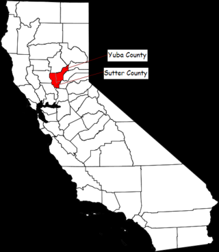
The Yuba–Sutter area, or Yuba City Metropolitan Statistical Area, is a smaller metropolitan community including Yuba and Sutter Counties in Northern California's Central Valley within the Greater Sacramento area.

<span class="mw-page-title-main">South Florida Fair</span> Annual city fair in West Palm Beach, Florida

The South Florida Fair is an annual fair held in West Palm Beach, Florida every January. The fairgrounds site occupies 100 acres and is located on the site of the former Palm Beach Speedway at the intersection of Southern Boulevard and Fairground Road, adjacent to the iTHINK Financial Amphitheatre. In 2012, the fair celebrated its 100th anniversary since its founding in 1912. Nearly 500,000 people attend the South Florida Fair each year.

The Toyota Amphitheatre is an outdoor amphitheater in unincorporated Yuba County, California, United States. It lies in-between Plumas Lake and Wheatland; 35 miles north of Sacramento and 10 miles south of Marysville. It holds 18,500 spectators and is primarily used for rock and country concerts.

Swanston Estates is a neighborhood situated in North Sacramento, California. It is bordered by Arden Way on the south, Ethan Way on the East, Business 80 on the west, and El Camino Avenue on the north. This area lies behind the Arden Fair Mall. The zip code for the neighborhood is 95815.

<span class="mw-page-title-main">California State Fair</span> Annual state fair in Sacramento, California

The California State Fair (CSF) is the annual state fair for the state of California. The fair is held at Cal Expo in Sacramento, California. The Fair is a 17-day event showcasing California's industries, agriculture, and diversity of people. The CSF features blue-ribbon animal displays, culinary delights and competitions, live music concerts, a carnival, fireworks, and other family fun. In 2018, officials reported daily attendance drew between 20,000 and 60,000 people per day and about $8.5 million of food and beverage expenditures. The fair is policed by the California Exposition and State Fair Police.

California State Fairgrounds Race Track has been the name of two dirt oval racing tracks located in Sacramento, California. The track was built in 1906 for horse racing on the site of the California Exposition. It was active for auto racing in 1907, 1912, and from 1946 until 1970. The Exposition moved to a new site north of Downtown Sacramento in 1968, and the old fairgrounds were closed and sold for development in 1970. The final day of the track was marred by tragedy when three drivers were killed in the 100-lap super-modified caged sprint car competition.

The Cal Expo Amphitheatre was a 14,000-capacity outdoor amphitheatre located in Sacramento, California, on the site of the California Exposition.

Bushy Lake is a small lake located in Sacramento, California along the American River Parkway. The area is part of an ongoing restoration project, it also provides habitat to wildlife and offers nearby recreation opportunities. The area is prone to drought, erosion, species invasion, fire, and groups of transient populations. In the American River Parkway Plan, the lake is designated as a Nature Study Area and further protected by the Bushy Lake Preservation Act.

<span class="mw-page-title-main">Santa Clara County Fairgrounds</span> Event venue in San Jose, California, U.S.

The Santa Clara County Fairgrounds is an event venue in San Jose, California. The 165-acre (67 ha) fairgrounds has been owned by the County of Santa Clara since 1940 and is operated by the Santa Clara County Fairgrounds Management Corporation, a public-benefit nonprofit corporation.

<span class="mw-page-title-main">Little Mandeville Island</span> Island in California

Little Mandeville Island is a small, mostly submerged island in the San Joaquin River delta, in California. It is part of San Joaquin County, and its coordinates are 38.0104776°N 121.5649522°W. In 1994, 376 acres (152 ha) of former farmland was inundated with water after a levee broke.

<span class="mw-page-title-main">California Exposition and State Fair Police</span>

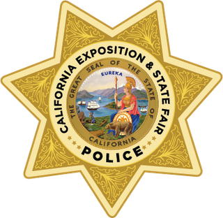
The California Exposition and State Fair Police is the police department of the California Exposition and State Fair, responsible for policing the California Exposition, including most notably the California State Fair. The sworn personnel of the Department have statewide peace officer powers as provided by section 830.2(i) of the California Penal Code.

<span class="mw-page-title-main">Headreach Island</span> Island in California

Headreach Island is a small island in the Sacramento–San Joaquin River Delta, in northern California. A naturally-formed island existing in a complex with Tule Island to the southeast and Fern Island to the northwest, it was used for farming as late as the 1920s. While several proposals for real estate development on the island were made in the late 20th century, it now consists mostly of marsh and submerged land. Black rails live on the island.

<span class="mw-page-title-main">Spud Island</span> Island in California

Spud Island is a small island of the San Joaquin River, located in the Sacramento–San Joaquin River Delta in northern California. It was once used to farm onions; while it is no longer used for agriculture, it remains inhabited. In the late 20th century it was the site of a county park, which offered camping, fishing and swimming amenities free of charge.

<span class="mw-page-title-main">Tule Island</span> Island in California

Tule Island is a small island in the Sacramento–San Joaquin River Delta, which exists as part of a complex of islands including directly-adjacent Fern Island and Headreach Island. It is a naturally-formed island, which was used in the early 20th century to farm potatoes, but now consists mostly of marsh. It is currently a habitat for waterfowl and is used as a fishing spot.

<span class="mw-page-title-main">Atlas Tract</span> Island in California

The Atlas Tract is an island in the Sacramento–San Joaquin River Delta, in San Joaquin County, California. It has been used for agriculture since it was first reclaimed in the late 19th century.

<span class="mw-page-title-main">Empire Tract</span> Island in California

The Empire Tract is an island in the Sacramento–San Joaquin River Delta in San Joaquin County, California, United States. It has been used for agriculture since the 1800s; in the early 20th century it was used to plant potatoes, and United States president Herbert Hoover operated a beet farm there. In the 1960s, natural gas deposits were discovered beneath the island. In 1936, it was connected to the mainland by the Eight Mile Road Bridge, across King Island. As with many islands in the Delta, the Empire Tract has experienced considerable subsidence, and is well below sea level.

<span class="mw-page-title-main">Terminous Tract</span> Island in California

The Terminous Tract is an island in the Sacramento–San Joaquin River Delta. It is part of San Joaquin County, California, and managed by Reclamation District 548. Its coordinates are 38°06′45″N121°27′27″W, and the United States Geological Survey measured its elevation as −7 ft (−2.1 m) in 1981. The census-designated place of Terminous, California is on the island.

References

  1. California State Assembly. "An Act to Incorporate a State Agricultural Society, and Appropriate Money for its Support". Fifth Session of the Legislature. Statutes of California. State of California. Ch. LI p. 56. direct URL
  2. "The State Agricultural Fair". Daily Alta California. October 6, 1854. Retrieved 13 June 2023.
  3. "CHL No. 861 First California State Fair Site - San Francisco". California Historical Landmarks. Retrieved 13 June 2023.
  4. "State Agricultural Fair". Sacramento Daily Union. September 26, 1855. Retrieved 13 June 2023.
  5. "The State Agricultural Fair". Sacramento Daily Union. October 10, 1856. Retrieved 13 June 2023.
  6. "Opening address at the State Fair". Sacramento Daily Union. October 1, 1857. Retrieved 13 June 2023.
  7. Bell, Samuel B. (August 26, 1858). "Annual Address delivered before the State Agricultural Society, at its fifth fair, at Marysville, August 25, 1858". Sacramento Daily Union. Retrieved 13 June 2023.
  8. 1 2 "Take Me to the Fair: Then and Now". Stockton Boulevard Partnership. October 5, 2020. Retrieved 13 June 2023.
  9. 1 2 Cosper, Alex (July 16, 2012). "Tracking State Fair History, Wondering Where its Going". Sacramento Press. Retrieved May 23, 2019.
  10. "New drugs, big neighbors and more change". UC Davis Health. Retrieved 13 June 2023.
  11. "California Exposition Dedication, May 22, 1967". oac.cdlib.org. Retrieved 2020-09-29.
  12. "The man behind the State Fair Monorail". ABC10. 14 July 2017. Retrieved 2 July 2021.
  13. Weber, Ron (March 11, 2009). "Butler Amusements signs 10 year deal with Cal Expo". Carnival Warehouse. Retrieved 13 June 2023.
  14. "Show Arena". Cal Expo. Retrieved 2 February 2024.
  15. "Californian speedway tracks". Speedway Bikes.com. Retrieved 2 February 2024.
  16. "World Championship". Metal Speedway. Retrieved 2 February 2024.
  17. "World Championship". Speedway.org. Retrieved 2 February 2024.

38°35′36″N121°26′05″W / 38.59337°N 121.434765°W / 38.59337; -121.434765