Cambridgeshire and Isle of Ely

Last updated

Cambridgeshire and Isle of Ely
EnglandCambridgeshireIsleOfEly.png
Population
  1971303,042
History
  Created1965
  Abolished1974
  Succeeded by Cambridgeshire
Status Administrative county
Government Cambridgeshire and Isle of Ely County Council
   HQ Cambridge
   Motto Sapientes Simus (Let us be men of wisdom)
Arms of Cambridgeshire and Isle of Ely County Council.svg

Cambridgeshire and Isle of Ely was, from 1965 to 1974, an administrative and geographical county in East Anglia in the United Kingdom. In 1974 it became part of an enlarged Cambridgeshire.

Contents

Formation

Map of the historical administrative boundaries in modern Cambridgeshire. Cambridgeshire and Isle of Ely, borders shown in red, covered the area of the current districts of Fenland, East Cambridgeshire, South Cambridgeshire, and the City of Cambridge. Historical Administrative Boundaries in Cambridgeshire.svg
Map of the historical administrative boundaries in modern Cambridgeshire. Cambridgeshire and Isle of Ely, borders shown in red, covered the area of the current districts of Fenland, East Cambridgeshire, South Cambridgeshire, and the City of Cambridge.

The Local Government Act 1888 created four small neighbouring administrative counties in the east of England: Cambridgeshire, Isle of Ely, Huntingdonshire and the Soke of Peterborough. Following the Second World War, a Local Government Boundary Commission was formed to review county-level administration in England and Wales. The commission was of the opinion that counties needed to have a population of between 200,000 and 1 million to provide effective services. Accordingly, they recommended the amalgamation of all four counties into a single entity. [1] [2] The commission's recommendations were not carried out, however.

The reform of local government was returned to in 1958, with the appointment of a Local Government Commission for England. The four counties were included in the East Midlands General Review Area, and the LGCE made its draft proposals in April 1960. The commission identified particular problems in the administration of Cambridgeshire, where the city of Cambridge had 50% of the population and over two-thirds of the rateable value of the county. Cambridge was large enough to qualify for county borough status and be removed from the administrative county, but it was felt that this would render the remainder of Cambridgeshire, which would consist of three rural districts, too small to effectively deliver local services. The LGCE made draft proposals to constitute Cambridge a county borough and create a new administrative county by merging the remainder of the county with the Isle of Ely, Huntingdonshire and the Soke of Peterborough. [3] There was considerable opposition to the draft proposals, and the LGCE instead opted in its final report in 1961 to create two counties: Huntingdon and Peterborough, and Cambridgeshire and Isle of Ely, with Cambridge continuing to form part of the latter county.

The Cambridgeshire and Isle of Ely Order was made on 14 February 1964, and placed before the House of Commons on 9 March 1964. The amalgamation was opposed by Sir Harry Legge-Bourke, MP for the Isle of Ely, noting that his constituents "in general were in favour of continuing with an independent county council with which they were entirely satisfied." Legge-Bourke asked why the Isle was to be abolished as a county, when Rutland was being retained, and went on to state that some parts of the area had more interests in common with Peterborough than Cambridge. The MP for Cambridge, Sir Hamilton Kerr also objected to the creation of the new county, advocating the original draft proposals and the elevation of his constituency to become a county borough. Nevertheless, the order was approved by 144 votes to 84. [3]

The new county was formed on 1 April 1965 from the areas of the administrative counties of Cambridgeshire and Isle of Ely (with minor boundary changes) less Thorney Rural District. As well as becoming an administrative county, Cambridgeshire and Isle of Ely also became a county for other statutory purposes. Accordingly, the Lord Lieutenant of Cambridgeshire was retitled Lord Lieutenant of Cambridgeshire and Isle of Ely. A High Sheriff was also appointed to the new county, and a single commission of peace and court of quarter sessions established. [3] [4]

On the creation of the county an order under the Police Act 1964 came into force creating the Mid-Anglia Constabulary by merging the Cambridge City Police, Cambridgeshire County Constabulary, Isle of Ely Constabulary, Huntingdonshire Constabulary, and the Peterborough Combined Police Force. On further local government reform in 1974 this became the present Cambridgeshire Constabulary with the same boundaries. [5]

The county ranked 33 out of 46 by population.

Districts

The county was divided into twelve districts: two municipal boroughs, four urban districts and six rural districts. The districts, which were transferred from the previous administrative counties, were: [6]

DistrictArea (acres)Population 1961 [7] Population 1971 [8]
City of Cambridge MB†10,06095,52798,840
Wisbech MB‡4,61717,52817,015
Chatteris UD‡15,1075,4915,578
City of Ely UD14,6599,8039,965
March UD19,78713,14414,285
Whittlesey UD‡22,2639,32210,458
Chesterton RD111,69244,57653,660
Ely RD66,08214,44215,355
Newmarket RD81,10120,87923,786
North Witchford RD24,7004,7404,352
South Cambridgeshire RD112,21329,40236,754
Wisbech RD49,84112,55112,994
TOTAL303,042

† Formerly in Cambridgeshire ‡ Formerly in Isle of Ely

Coat of arms

Coat of arms of the Cambridgeshire and Isle of Ely County Council Arms of Cambridgeshire and Isle of Ely County Council.svg
Coat of arms of the Cambridgeshire and Isle of Ely County Council
Arms of Cambridgeshire County Council 1914-1965.svg
Arms of Cambridgeshire County Council, granted in 1914.
Arms of Isle of Ely County Council.svg
Arms of Isle of Ely County Council, granted in 1931.
Coats of arms of the former county councils.

The county council was granted armorial bearings by the College of Arms on 1 September 1965. The coat of arms was a combination of those of the two merged county councils. The blazon of the arms was as follows:

Or a double tressure flory counter flory gules, overall on a bend wavy azure three crowns or; the shield ensigned by a mural crown or. Supporters: on either side a great bustard proper, the exterior leg resting on a closed book gules, garnished or. Badge: Within an annulet issuant therefrom four fleurs-de-lys in cross an open crown or. [9]

The gold field and red tressure flory counter flory were taken from the royal arms of Scotland. This was in reference to the fact that the Earldom of Cambridge was held by David I of Scotland in the twelfth century. The blue wave represented the River Cam on which were three crowns from the arms of the Diocese of Ely. The supporters were great bustards, a bird extinct in England, whose last habitat was said to have been in the county. [10] The birds were differenced from those supporting the previous Cambridgeshire arms by the placing of a red book beneath their feet. The book came from the arms of the University of Cambridge. The Latin motto adopted also referred to the university, and was Sapientes Simus or "Let us be men of understanding".

Abolition

The county had only a brief existence: the Local Government Act 1972 reformed all administrative structures in England and Wales outside Greater London. On 1 April 1974, Cambridgeshire and Isle of Ely was merged with Huntingdon and Peterborough to form a new non-metropolitan county of Cambridgeshire, bringing into effect the amalgamation originally proposed in 1947.

Related Research Articles

<span class="mw-page-title-main">Cambridgeshire</span> County of England

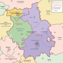
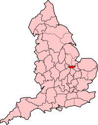
Cambridgeshire is a ceremonial county in the East of England and East Anglia. It is bordered by Lincolnshire to the north, Norfolk to the north-east, Suffolk to the east, Essex and Hertfordshire to the south, and Bedfordshire and Northamptonshire to the west. The largest settlement is the city of Peterborough, and the city of Cambridge is the county town.

<span class="mw-page-title-main">Huntingdonshire</span> Historic county and now a district of Cambridgeshire, England

Huntingdonshire is a local government district of Cambridgeshire and a historic county of England. The district council is based in Huntingdon. Other towns include Godmanchester, Kimbolton, Ramsey, St Ives and St Neots. The population was 180,800 at the 2021 Census.

<span class="mw-page-title-main">Counties of England</span> Englands administrative, geographical and political demarcation

The counties of England are areas used for different purposes, which include administrative, geographical, cultural and political demarcation. The term "county" is defined in several ways and can apply to similar or the same areas used by each of these demarcation structures. These different types of county each have a more formal name but are commonly referred to as just "counties". The current arrangement is the result of incremental reform.

<span class="mw-page-title-main">Ceremonial counties of England</span> Category of areas in England

The counties for the purposes of the lieutenancies in England, also referred to as the lieutenancy areas of England and informally known as ceremonial counties, are areas of England to which lord-lieutenants are appointed. Legally, the areas in England, Wales, and Scotland are defined by the Lieutenancies Act 1997 as "counties and areas for the purposes of the lieutenancies in Great Britain", in contrast to the metropolitan and non-metropolitan counties of England used for local government. They are also informally known as "geographic counties", to distinguish them from other types of counties in England.

<span class="mw-page-title-main">City of Peterborough</span> City and Unitary Authority in Cambridgeshire, England

Peterborough, commonly known as the City of Peterborough, is a unitary authority district with city status in the ceremonial county of Cambridgeshire, England. The area is named after its largest settlement, Peterborough but also covers a wider area of outlying villages and hamlets.

<span class="mw-page-title-main">Soke of Peterborough</span> Historic area of England

The Soke of Peterborough is a historic area of England associated with the City and Diocese of Peterborough, but considered part of Northamptonshire. The Soke was also described as the Liberty of Peterborough, or Nassaburgh hundred, and comprised, besides Peterborough, about thirty parishes.

<span class="mw-page-title-main">Huntingdon and Peterborough</span> Former county in England

Huntingdon and Peterborough was a short-lived administrative and geographical county in East Anglia in the United Kingdom. It existed from 1965 to 1974, when it became part of Cambridgeshire.

<span class="mw-page-title-main">Cambridgeshire Constabulary</span> English territorial police force

Cambridgeshire Constabulary is the local territorial police force that covers the county of Cambridgeshire and Peterborough unitary authority. It provides law enforcement and security for an area of 1,311 square miles (3,400 km2) and population of 856,000 people, in a predominantly rural county. The force of Cambridgeshire includes the cities of Cambridge, Ely and Peterborough, the market towns of Chatteris, Huntingdon, March, Ramsey, St Ives, St Neots, Whittlesey, and town and Port of Wisbech. Its emblem is a crowned Brunswick star containing the heraldic badge of Cambridgeshire County Council.

<span class="mw-page-title-main">Stanground</span> Residential area of Peterborough, Cambridgeshire, United Kingdom

Stanground is a residential area of Peterborough, in the ceremonial county of Cambridgeshire, England. For electoral purposes, it comprises the Stanground South and Fletton & Stanground wards in the North West Cambridgeshire constituency.

<span class="mw-page-title-main">Fletton</span> Human settlement in England

Fletton is an area of the city of Peterborough, in the Peterborough district, in the ceremonial county of Cambridgeshire, England, south of the River Nene.

<span class="mw-page-title-main">Mid-Anglia Constabulary</span>

The Mid-Anglia Constabulary was the territorial police force responsible for law enforcement in part of the East of England, from 1965 to 1974. It was created from the amalgamation of five forces. It was renamed Cambridgeshire Constabulary in 1974.

<span class="mw-page-title-main">Peterborough City Council</span> Local authority in England

Peterborough City Council is the local authority for Peterborough in the East of England. It is a unitary authority, having the powers of a non-metropolitan county and district council combined. The City was incorporated as a municipal borough in 1874; from 1888, it fell within the jurisdiction of the Soke of Peterborough county council and from 1965, Huntingdon and Peterborough county council. In 1974, it was replaced by a wholly new non-metropolitan district, broadly corresponding to the Soke, in the new enlarged Cambridgeshire. In 1998, Peterborough became independent of Cambridgeshire as a unitary authority, but the city continues to form part of that county for ceremonial purposes as defined by the Lieutenancies Act 1997.

The Local Government Commission for England was established by the Local Government Act 1958 to review the organisation of local government, and make "such proposals as are hereinafter authorised for effecting changes appearing to the Commissions desirable in the interests of effective and convenient local government". Most of the commission's proposals failed to reach consensus and were not implemented, and the body was dissolved in 1967.

The Local Government Boundary Commission was established in 1945 to review the boundaries of local authority areas in England and Wales outside the Counties of London and Middlesex. The Commission produced its report in 1948 which proposed large changes to county-level areas of local government and changes in the structure and division of powers between tiers of administration. The Commission's proposals were not acted on, and it was disbanded in 1949.

<span class="mw-page-title-main">Local Government Commission for England (1992)</span> United Kingdom legislation

The Local Government Commission for England was the body responsible for reviewing the structure of local government in England from 1992 to 2002. It was established under the Local Government Act 1992, replacing the Local Government Boundary Commission for England. The Commission could be ordered by the Secretary of State to undertake "structural reviews" in specified areas and recommend the creation of unitary authorities in the two-tier shire counties of England. The Commission, chaired by John Banham, conducted a review of all the non-metropolitan counties of England from 1993 to 1994, making various recommendations on their future.

<span class="mw-page-title-main">Local Government (Boundaries) Act 1887</span> United Kingdom legislation

The Local Government (Boundaries) Act 1887 was an Act of the Parliament of the United Kingdom. The Act established boundary commissioners to reform the areas of administrative bodies in England and Wales in preparation for the creation of elected councils by the Local Government Act 1888. In the event, the recommendations of the commissioners were not carried out.

Cambridge City Police was the territorial police force responsible for law enforcement in Cambridge, England, from 1836 to 1965. From its creation until April 1951 it was known as Cambridge Borough Police. It subsequently merged with four other police forces to become what is known today as Cambridgeshire Constabulary.

Peterborough Combined Police was the territorial police force responsible for law enforcement in Peterborough, England, from 1947 to 1965. It was created from the amalgamation of the Liberty of Peterborough Constabulary and the Peterborough City Police.

The ceremonial county of Cambridgeshire, which includes the unitary authority of Peterborough, has returned 7 MPs to the UK Parliament since 1997.

References

  1. Local Government Boundary Commission, Report for the Year 1946, 3 April 1947 and Report for the Year 1947, 11 March 1948
  2. E. W. Gilbert, The Boundaries of Local Government Areas, The Geographical Journal, Vol. 111, No. 4/6. (April – June 1948), pp. 172–198
  3. 1 2 3 "Local Government (East Midlands) HC Deb 09 March 1964 vol 691 cc170-211". Parliamentary Debates (Hansard) . 9 March 1964. Archived from the original on 26 June 2009. Retrieved 5 June 2008.
  4. The Cambridgeshire and Isle of Ely Order (SI 1964/366), see Local Government Commission for England, Report and Proposals for the East Midlands General Review Area (Report No.3), 31 July 1961 and Report and Proposals for the Lincolnshire and East Anglia General Review Area (Report No.9), 7 May 1965
  5. Cambridgeshire Constabulary History Archived 6 November 2007 at the Wayback Machine The Badgers Lair (retrieved 11 December 2005)
  6. Vision of Britain – Cambridgeshire and Isle of Ely [ permanent dead link ]
  7. "1961 Census of England and Wales, County Report:Cambridgeshire". Vision of Britain. Retrieved 6 June 2008.[ permanent dead link ]
  8. 1971 Census; Small Area Statistics
  9. Geoffrey Briggs, Civic and Corporate Heraldry, London, 1971
  10. C W Scott-Giles, Civic Heraldry of England and Wales, 2nd edition, London 1953

52°13′N0°06′E / 52.217°N 0.100°E / 52.217; 0.100