
Thurso is a town and former burgh on the north coast of the Highland council area of Scotland. Situated in the historical area of Caithness, it is the northernmost town on the British mainland.

Caithness is a historic county, registration county and lieutenancy area of Scotland.

Helmsdale is a village on the east coast of Sutherland, in the Highland council area of Scotland. The modern village was planned in 1814 to resettle communities that had been removed from the surrounding straths as part of the Highland Clearances.

Dunnet Head is a peninsula in Caithness, on the north coast of Scotland. Dunnet Head includes the most northerly point of both mainland Scotland and the island of Great Britain.
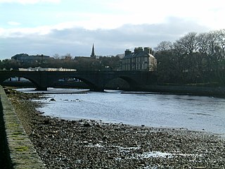
Wick is a town and royal burgh in Caithness, in the far north of Scotland. The town straddles the River Wick and extends along both sides of Wick Bay. "Wick Locality" had a population of 6,954 at the time of the 2011 census, a decrease of 3.8% from 2001.

Keith is a small town in the Moray council area in north east Scotland. It has a population of 4,734.

Castletown is a village on the north coast of the Highland council area of Scotland, situated near Dunnet Bay. It is within the civil parish of Olrig, where it is the main settlement, and within the historic county of Caithness. The A836 links the village with Thurso and Tongue in the west and with John o' Groats in the east. The B876-A99 links the village with Wick in the southeast. Contrary to the common misconception, the name Castletown is a misnomer as there is no castle within the village limits.
Dunnet is a village in Caithness, in the Highland area of Scotland. It is within the Parish of Dunnet.

Duncansby Head is the most northeasterly part of both the Scottish and British mainlands, slightly northeast of John o' Groats. It lies approximately 20 km east-southeast of Dunnet Head, the northernmost point of both the Scottish and British mainlands. Duncansby Head is located in Caithness, Highland, in north-eastern Scotland. The headland juts into the North Sea, with the Pentland Firth to its north and west and the Moray Firth to its south.
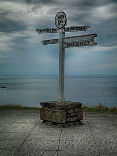
Land's End to John o' Groats is the traversal of the whole length of the island of Great Britain between two extremities, in the southwest and northeast. The traditional distance by road is 874 miles (1,407 km) and takes most cyclists 10 to 14 days; the record for running the route is nine days. Off-road walkers typically walk about 1,200 miles (1,900 km) and take two or three months for the expedition. Signposts indicate the traditional distance at each end.

Lybster is a village on the east coast of Caithness in northern Scotland. It was once a big herring fishing port.

Berriedale is a small estate village on the northern east coast of Caithness, Scotland, on the A9 road between Helmsdale and Lybster, close to the boundary between Caithness and Sutherland. It is sheltered from the North Sea. The village has a parish church in the Church of Scotland.

Huna is a small remote crofting township, located 1 mile northeast of Canisbay and 1.5 miles west of John o' Groats in Caithness, in Scotland. It is currently part of the Highland Council area.

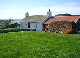
Badbea is a former clearance village perched on the steep slopes above the cliff tops of Berriedale on the east coast of Caithness, Scotland. Situated around 5 miles (8 km) north of Helmsdale, the village was settled in the 18th and 19th centuries by families evicted from their homes when the straths of Langwell, Ousdale and Berriedale were cleared for the establishment of sheep farms. The last resident left the village in 1911 and a monument was erected by the son of former inhabitant, Alexander Robert Sutherland, who had emigrated to New Zealand in 1839. Today, the ruins of the village are preserved as a tourist attraction and memorial to the Highland Clearances.
Reiss is a village in the former county of Caithness, now in the Highland council area of northern Scotland. It is well known in the Caithness area for its beach and also the 18-hole Wick golf course.

John o' Groats is a village 2.5 mi (4 km) northeast of Canisbay, Caithness, in the far north of Scotland. John o' Groats lies on Great Britain's northeastern tip, and is popular with tourists as one end of the longest distance between two inhabited British points on the mainland, with Land's End in Cornwall lying 876 mi (1,410 km) southwest, but it is not the northernmost point of Great Britain, which is the nearby Dunnet Head.

Mey is a remote village, located on the north coast of Scotland in Caithness, Scottish Highlands and is in the Scottish council area of Highland.
The John o’Groats Trail is a Scottish long-distance walking route from Inverness to John o’Groats, traversing back lanes, footpaths, shorelines and cliff tops of the Scottish Highlands. The trail gives access to accommodation, meals and shops at the end of each stage of the walk.
Huna House is a Victorian building located in the small village of Huna in Canisbay, north of Caithness. Built in 1870 as the Huna Hotel, it is listed as a historic place at Historic Environment Scotland. The hotel, located on the eastern edge of a rocky coastline and an intertidal sandbank from Huna House to Scotland’s Haven, sits on a short cliff with views of the Island of Stroma, the double-lighthouse of Pentland Skerries, and the Orkney Islands.

Canisbay Parish Church is a Church of Scotland church in Canisbay, Scotland, that dates back to the early 1600s and is the most northernly church on mainland Britain. It is a Category A listed building. It is surrounded by a large cemetery, which is split into two sections, the new and old. It features a square bell tower, nave and a porch. The porch was added in 1891, when the other extensions and work was completed to the church building.


