
The Mississippi River is the second-longest river and chief river of the second-largest drainage system in North America, second only to the Hudson Bay drainage system. From its traditional source of Lake Itasca in northern Minnesota, it flows generally south for 2,340 miles (3,770 km) to the Mississippi River Delta in the Gulf of Mexico. With its many tributaries, the Mississippi's watershed drains all or parts of 32 U.S. states and two Canadian provinces between the Rocky and Appalachian mountains. The main stem is entirely within the United States; the total drainage basin is 1,151,000 sq mi (2,980,000 km2), of which only about one percent is in Canada. The Mississippi ranks as the thirteenth-largest river by discharge in the world. The river either borders or passes through the states of Minnesota, Wisconsin, Iowa, Illinois, Missouri, Kentucky, Tennessee, Arkansas, Mississippi, and Louisiana.

East Cape Girardeau is a village in Alexander County, Illinois, United States. The population was 289 at the 2020 census. It is part of the Cape Girardeau–Jackson, MO-IL Metropolitan Statistical Area.

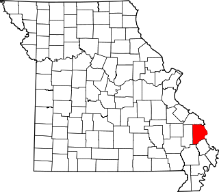
Cape Girardeau is a city in Cape Girardeau and Scott Counties in the U.S. state of Missouri. At the 2020 census, the population was 39,540. The city is one of two principal cities of the Cape Girardeau-Jackson, MO-IL Metropolitan Statistical Area, which encompasses Alexander County, Illinois, Bollinger County, Missouri and Cape Girardeau County, Missouri and has a population of 97,517. The city is the economic center of Southeast Missouri and also the home of Southeast Missouri State University. It is located approximately 100 miles (161 km) southeast of St. Louis and 150 miles (241 km) north of Memphis.

A truss bridge is a bridge whose load-bearing superstructure is composed of a truss, a structure of connected elements, usually forming triangular units. The connected elements may be stressed from tension, compression, or sometimes both in response to dynamic loads. The basic types of truss bridges shown in this article have simple designs which could be easily analyzed by 19th and early 20th-century engineers. A truss bridge is economical to construct because it uses materials efficiently.

The McKinley Bridge is a steel truss bridge across the Mississippi River. It connects northern portions of the city of St. Louis, Missouri with Venice, Illinois. It opened in 1910 and was taken out of service on October 30, 2001. The bridge was reopened for pedestrian and bicyclists on November 17, 2007 with a grand re-opening celebration. Since December 2007, McKinley has been open to vehicular traffic as well. It is accessible from Illinois Route 3 in Illinois and from the intersection of Salisbury and North 9th Street in the city of St. Louis. The bridge carried both railroad and vehicular traffic across the Mississippi River for decades. By 1978, the railroad line over the span was closed, and an additional set of lanes was opened for vehicles in the inner roadway.

The MacArthur Bridge is a truss bridge that connects St. Louis, Missouri and East St. Louis, Illinois over the Mississippi River. The bridge was initially called the "St. Louis Municipal Bridge" and known popularly as the "Free Bridge" due to the original lack of tolls. Tolls were added for auto traffic beginning in 1932. In 1942, the bridge was renamed for Douglas MacArthur. The bridge was constructed to break the monopoly of the Terminal Railroad Association, which controlled two other bridges at St. Louis and charged what were viewed as unreasonable tolls.

The Fort Madison Toll Bridge is a tolled, double-decked swinging truss bridge over the Mississippi River that connects Fort Madison, Iowa, and unincorporated Niota, Illinois. A double-track railway occupies the lower deck of the bridge, while two lanes of road traffic are carried on the upper deck. The bridge is about 1 mile (1.6 km) long with a swing span of 525 feet (160 m), and was the longest and largest double-deck swing-span bridge in the world when constructed in 1927. It replaced an inadequate combination roadway/single-track bridge completed in 1887. The main river crossing consists of four 270-foot (82 m) Baltimore through truss spans and a swing span made of two equal arms, 266 feet (81 m) long. In 1999, it was listed in the National Register of Historic Places under the title, Fort Madison Bridge, ID number 99001035. It was also documented as survey number IA-62 by the Historic American Engineering Record, archived at the Library of Congress. Construction and photographic details were recorded at the time in Scientific American magazine.

The Clark Bridge is a cable-stayed bridge across the Mississippi River between West Alton, Missouri and Alton, Illinois. Named after explorer William Clark like the bridge it replaced, the cable-stayed bridge opened in 1994. It carries U.S. Route 67 across the river. It is the northernmost river crossing in the St. Louis metropolitan area.

The Cairo Mississippi River Bridge is a type of cantilever bridge known as a Steel Truss Through Deck carrying U.S. Route 60 and U.S. Route 62 across the Mississippi River. Located in the tri-state area of Illinois, Kentucky, and Missouri, it connects Cairo, Illinois at its northern terminus to Bird's Point, Missouri at its southern terminus. The bridge was most recently closed for renovation from March 16, 2015 to October 13, 2015.

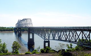
The Bill Emerson Memorial Bridge is a cable-stayed bridge connecting Missouri's Route 34 and Route 74 with Illinois Route 146 across the Mississippi River between Cape Girardeau, Missouri and East Cape Girardeau, Illinois.
The Chester Bridge is a continuous truss bridge connecting Missouri's Route 51 with Illinois Route 150 across the Mississippi River between Perryville, Missouri and Chester, Illinois. It is the only motor-traffic bridge spanning the Mississippi River between St. Louis and Cape Girardeau, Missouri.

The Quincy Rail Bridge is a truss bridge that carries a rail line across the Mississippi River between West Quincy, Missouri, and Quincy, Illinois, USA. It was originally constructed in 1868 for the Chicago, Burlington and Quincy Railroad, a predecessor of BNSF Railway.

A continuous truss bridge is a truss bridge which extends without hinges or joints across three or more supports. A continuous truss bridge may use less material than a series of simple trusses because a continuous truss distributes live loads across all the spans; in a series of simple trusses, each truss must be capable of supporting the entire load.

Interstate 66 (I-66) is a cancelled interstate designated in the Intermodal Surface Transportation Efficiency Act (ISTEA) of 1991 as the East–West TransAmerica Corridor and High Priority Corridor 3. The United States Department of Transportation originally planned to extend the current I-66 from its western terminus at Middletown, Virginia, across the country to California. The route west of Kansas was not favored by any of the related state highway departments, and as a result I-66 west of Wichita, Kansas, through New Mexico, Arizona, Nevada and California was cancelled. Among the reasons for this were lack of interest from any of the state highway departments, and the insufficient projected traffic did not justify an Interstate, especially since many segments had no pre-existing highway. The National Park Service was strongly opposed to building I-66 across the Death Valley National Park. The choice for the number I-66 was a hope to capitalize on name association with the decommissioned U.S. Route 66 (US 66). The case for westward expansion of I-66 was started by businesspeople in Wichita. Furthermore, there were no plans to build I-66 across the West Virginia–Virginia state line, leaving it as a non-contiguous highway. The I-66 concept was supported in Kentucky mainly because of the efforts of Congressman Hal Rogers, however the Kentucky Transportation Cabinet completed its feasibility study in 2005 and concluded that building I-66 was too costly and of little traffic benefit with high potential environmental impact and cancelled the project in that state. The only remaining study of I-66 was conducted by the Federal Highway Administration (FHWA) and the Illinois Department of Transportation (IDOT) under the 66 Corridor Study, a Tier 1 environmental impact study (EIS). This study was cancelled August 6, 2015, by IDOT, and subsequently the FHWA announced the cancellation of the EIS in the Federal Register, ending the last I-66 project and therefore officially cancelling the I-66 Trans America Highway.

Interstate 55 (I-55) in the US state of Missouri runs from the Arkansas state line to the Poplar Street Bridge over the Mississippi River in St. Louis.
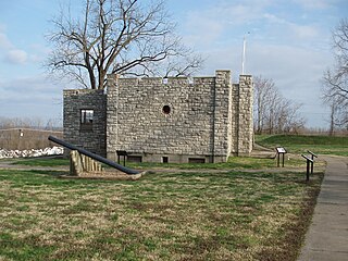
Fort D is a Civil War-era fort alongside the Mississippi River in Cape Girardeau, Missouri, USA.

The Highway 78 Bridge at the Red River is an eight-span through truss bridge over the Red River between Oklahoma and Texas on Oklahoma State Highway 78/Texas State Highway 78. It was built as a federal relief project during the Great Depression as part of President Franklin Roosevelt's New Deal. Today the bridge and the area retain the look and feel of the time of its construction. As part of Highway 78 the bridge's average daily traffic was 1,700 cars per day.

The Lake Shore Drive Bridge, also known as the M-26 Bridge or the Eagle River Bridge, is a pedestrian bridge in Eagle River, Michigan, crossing the Eagle River. It carried highway M-26 over the river from 1915 until 1990, when the adjacent Eagle River Timber Bridge replaced it for automobile traffic. The Lake Shore Drive Bridge is listed as a Michigan State Historic Site and is a contributing property of the Eagle River Historic District.
Neely's Landing or Neelys Landing is an unincorporated community in Shawnee Township in northern Cape Girardeau County, Missouri, United States. It is located seventeen miles north of Cape Girardeau and is part of the Cape Girardeau–Jackson, MO-IL Metropolitan Statistical Area.

The Champ Clark Bridge was a five-span truss bridge over the Mississippi River connecting Louisiana, Missouri with the state of Illinois.

