
The Tyrrhenian Sea is part of the Mediterranean Sea off the western coast of Italy. It is named for the Tyrrhenian people identified with the Etruscans of Italy.
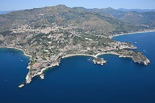
Taormina is a comune (municipality) in the Metropolitan City of Messina, on the east coast of the island of Sicily, Italy. Taormina has been a tourist destination since the 19th century. Its beaches on the Ionian sea, including that of Isola Bella, are accessible via an aerial tramway built in 1992, and via highways from Messina in the north and Catania in the south. On 26–27 May 2017 Taormina hosted the 43rd G7 summit.

Ponza is the largest island of the Italian Pontine Islands archipelago, located 33 km (21 mi) south of Cape Circeo in the Tyrrhenian Sea. It is also the name of the commune of the island, a part of the province of Latina in the Lazio region.

Ricadi is a small rural town, as well as a municipality, located along the Tyrrhenian coast, in the province of Vibo Valentia, in the Italian region of Calabria.
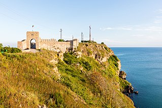
Kaliakra is a cape in the Southern Dobruja region of the northern Bulgarian Black Sea Coast, which ends with a long and narrow headland 12 kilometres (7 mi) east of Kavarna, 60 kilometres (37 mi) northeast of Varna and 65 kilometres (40 mi) southwest of Mangalia. The coast is steep with vertical cliffs reaching 70 metres (230 ft) down to the sea. Kaliakra is a nature reserve, where dolphins and cormorants can be observed. It sits on the Via Pontica, a major bird migration route from Africa into Eastern and Northern Europe. Many rare and migrant birds can be seen here in spring and autumn and, like much of this coastline, is home to several rare breeding birds. The rest of the reserve also has unusual breeding birds; saker falcon, lesser grey shrike and a host of others.
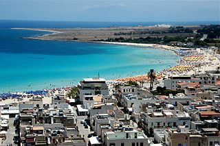
San Vito Lo Capo is a town and comune in North-Western Sicily, Italy, administratively part of the province of Trapani. The small town is located in a valley between mountains, and is home to a public beach that is destination of local vacationers.
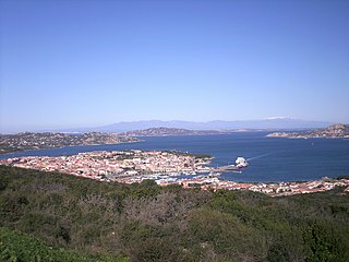
Palau is a comune (municipality) in the Province of Sassari in the Italian region Sardinia, about 220 kilometres (140 mi) north of Cagliari and about 30 kilometres (19 mi) northwest of Olbia. It was a frazione of the comune of Tempio Pausania until 1959.
Capo or capos, may refer to:

The Vatican Railway was opened in 1934 to serve Vatican City and its only station, Vatican City. The main rail tracks are standard gauge and 300 metres (980 ft) long, with two freight sidings, making it the shortest national railway system in the world. Access to the Italian rail network is over a viaduct to Roma San Pietro railway station, and is guaranteed by the Lateran Treaty dating from 1929. The tracks and station were constructed during the reign of Pope Pius XI, shortly after the treaty.

Cape Carbonara is a promontory on the southeastern tip of Sardinia, Italy, which forms the eastern end of the Gulf of Cagliari. Together with the nearby Cavoli Island and Serpentara Island, it is included in the Italian National Marine Park of Capo Carbonara.
Capo Mannu is a promontory in Sardinia, Italy.

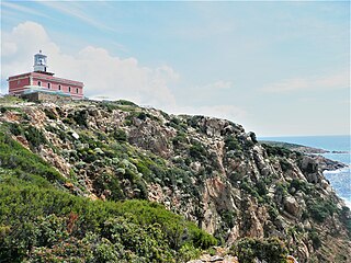
Capo Carbonara Lighthouse is a light situated at the extremity of the granite promontory of Capo Carbonara, in the comune of Villasimius, on the eastern side of Gulf of Cagliari inside the Marine protected area of Capo Carbonara.

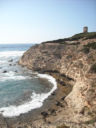
Capo Vaticano Lighthouse is an active lighthouse located in Capo Vaticano, which is a Cape in the south western Calabria on the Tyrrhenian Sea.

Capo Palinuro Lighthouse is an active lighthouse located in the south-western Italy, roughly 40 miles (64 km) south-west of Salerno, in the southern part of Cilento.

Capo d'Anzio Lighthouse is an active lighthouse located on the same name Cape on a rocky cliff overlooking the ruins of Nero's villa, close to the town of Anzio, Lazio on the Tyrrhenian Sea.
Capo Spartivento Lighthouse is an active lighthouse located on Cape Spartivento promontory which is the southernmost point of Sardinia and represents the eastern boundary of the Gulf of Teulada and the western limit of the Gulf of Cagliari on the Tyrrhenian Sea. The structure is situated in the municipality of Domus de Maria.

Capo Testa Lighthouse is an active lighthouse located on a promontory, which is the northernmost point of Sardinia, and represents the western entrance to the Strait of Bonifacio. Cape Testa promontory is connected to the mainland by an isthmus and the structure is situated in the municipality of Santa Teresa di Gallura on the Sea of Sardinia.

Capo Santa Croce Lighthouse is an active lighthouse located at the extreme tip of the cape, marking the northern end of the Gulf in the municipality of Augusta on the Ionian Sea.


