
The Niagara Escarpment is a long escarpment, or cuesta, in Canada and the United States that starts from the south shore of Lake Ontario westward, circumscribes the top of the Great Lakes Basin running from New York through Ontario, Michigan, and Wisconsin. The escarpment is the cliff over which the Niagara River plunges at Niagara Falls, for which it is named.

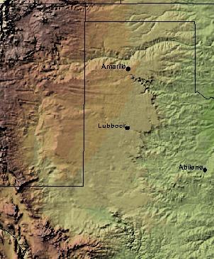
The Permian Basin is a large sedimentary basin in the southwestern part of the United States. It is the highest producing oil field in the United States, producing an average of 4.2 million barrels of crude oil per day in 2019. This sedimentary basin is located in western Texas and southeastern New Mexico. It reaches from just south of Lubbock, past Midland and Odessa, south nearly to the Rio Grande River in southern West Central Texas, and extending westward into the southeastern part of New Mexico. It is so named because it has one of the world's thickest deposits of rocks from the Permian geologic period. The greater Permian Basin comprises several component basins; of these, the Midland Basin is the largest, Delaware Basin is the second largest, and Marfa Basin is the smallest. The Permian Basin covers more than 86,000 square miles (220,000 km2), and extends across an area approximately 250 miles (400 km) wide and 300 miles (480 km) long.

A salt dome is a type of structural dome formed when salt intrudes into overlying rocks in a process known as diapirism. Salt domes can have unique surface and subsurface structures, and they can be discovered using techniques such as seismic reflection. They are important in petroleum geology as they can function as petroleum traps.
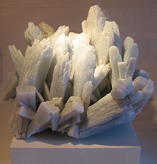
Anhydrite, or anhydrous calcium sulfate, is a mineral with the chemical formula CaSO4. It is in the orthorhombic crystal system, with three directions of perfect cleavage parallel to the three planes of symmetry. It is not isomorphous with the orthorhombic barium (baryte) and strontium (celestine) sulfates, as might be expected from the chemical formulas. Distinctly developed crystals are somewhat rare, the mineral usually presenting the form of cleavage masses. The Mohs hardness is 3.5, and the specific gravity is 2.9. The color is white, sometimes greyish, bluish, or purple. On the best developed of the three cleavages, the lustre is pearly; on other surfaces it is glassy. When exposed to water, anhydrite readily transforms to the more commonly occurring gypsum, (CaSO4·2H2O) by the absorption of water. This transformation is reversible, with gypsum or calcium sulfate hemihydrate forming anhydrite by heating to around 200 °C (400 °F) under normal atmospheric conditions. Anhydrite is commonly associated with calcite, halite, and sulfides such as galena, chalcopyrite, molybdenite, and pyrite in vein deposits.
A petroleum reservoir or oil and gas reservoir is a subsurface accumulation of hydrocarbons contained in porous or fractured rock formations.

The Cutler Formation or Cutler Group is a rock unit that is exposed across the U.S. states of Arizona, northwest New Mexico, southeast Utah and southwest Colorado. It was laid down in the Early Permian during the Wolfcampian epoch.
Texas contains a wide variety of geologic settings. The state's stratigraphy has been largely influenced by marine transgressive-regressive cycles during the Phanerozoic, with a lesser but still significant contribution from late Cenozoic tectonic activity, as well as the remnants of a Paleozoic mountain range.

In petroleum geology, a trap is a geological structure affecting the reservoir rock and caprock of a petroleum system allowing the accumulation of hydrocarbons in a reservoir. Traps can be of two types: stratigraphic or structural. Structural traps are the most important type of trap as they represent the majority of the world's discovered petroleum resources.
The Leduc Formation is a stratigraphic unit of Late Devonian (Frasnian) age in the Western Canada Sedimentary Basin. It takes its name from the city of Leduc, and it was formally described from the B.A. Pyrz No. 1 well in central Alberta, between the depths of 1,623.7 m (5,327 ft) and 1,807.5 m (5,930 ft), by Imperial Oil Limited in 1950. Supplementary information came from a complete section of the formation that was cored in Imperial Oil's Leduc No. 530 well between 1,633 m (5,358 ft) and 1,863 m (6,112 ft).

The Wind River Basin or Shoshone Basin is a semi-arid intermontane foreland basin in central Wyoming, United States. It is bounded by Laramide uplifts on all sides. On the west is the Wind River Range and on the North are the Absaroka Range and the Owl Creek Mountains. The Casper Arch separates the Wind River from the Powder River Basin to the east and the Sweetwater Uplift lies to the south. The basin contains a sequence of 10,000–12,000 feet of predominantly marine sediments deposited during the Paleozoic and Mesozoic Eras. During the Laramide over 18,000 feet of Eocene lacustrine and fluvial sediments were deposited within the basin. Following the Eocene an additional 3,000 feet of sediments were deposited before, and as the basin was uplifted in the late Tertiary.

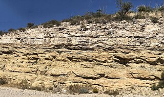
Cedar Mesa Sandstone is a sandstone member of the Cutler Formation, found in southeast Utah, southwest Colorado, northwest New Mexico, and northeast Arizona.
In geology, the Paradox Formation Is a Pennsylvanian age formation which consists of abundant evaporites with lesser interbedded shale, sandstone, and limestone. The evaporites are largely composed of gypsum, anhydrite, and halite. The formation is found mostly in the subsurface, but there are scattered exposures in anticlines in eastern Utah and western Colorado. These surface exposures occur in the Black Mesa, San Juan and Paradox Basins and the formation is found in the subsurface in southwestern Colorado, southeastern Utah, northeastern Arizona and northeastern New Mexico.
The salt tectonics off the Louisiana gulf coast can be explained through two possible methods. The first method attributes spreading of the salt because of sedimentary loading while the second method points to slope instability as the primary cause of gliding of the salt. The first method results in the formation of growth faults in the overlying sediment. Growth faults are normal faults that occur simultaneously with sedimentation, causing them to have thicker sediment layers on the downthrown sides of the faults. In the second method both the salt and the sediment are moving, making it more likely to migrate.

The Seven Rivers Formation is a geologic formation in southeastern New Mexico and west Texas. It preserves fossils dating back to the late Guadalupian Epoch of the Permian period.
The Tansill Formation is a geologic formation in southeastern New Mexico and west Texas, United States. It preserves fossils dating back to the late Guadalupian Age of the Permian period.

Theron Rhodes Wasson (1887–1970) was a leading American petroleum geologist and engineer, who pioneered the use of geophysical surveys to find oil and gas.

The Greater Green River Basin (GGRB) is a 21,000 square mile basin located in Southwestern Wyoming. The Basin was formed during the Cretaceous period sourced by underlying Permian and Cretaceous deposits. The GGRB is host to many anticlines created during the Laramide Orogeny trapping many of its hydrocarbon resources. It is bounded by the Rawlins Uplift, Uinta Mountains, Sevier overthrust belt, Sierra Madre Mountains, and the Wind River Mountain Range. The Greater Green River Basin is subdivided into four smaller basins, the Green River Basin, Great Divide Basin, Washakie Basin, and Sand Wash Basin. Each of these possesses hydrocarbons that have been economically exploited. There are 303 named fields throughout the basin, the majority of which produce natural gas; the largest of these gas fields is the Jonah Field.

The Alaskan North Slope (ANS) is a foreland basin located on the northern edge of the Brooks Range. The Alaska North Slope is bounded on the north by the Beaufort Sea and runs from the Canadian border to the maritime boundary with Russia in the west. The western edge extends into the Chukchi Sea and Chukchi platform where the basin is at its widest. As the basin moves east it narrows towards the Canadian border. The basin is 1000 km long, 600 km at its widest, and covers a total area of 240,000 km2.
The Grayburg Formation is a geologic formation in west Texas and southern New Mexico. It preserves fossils dating back to the Guadalupian Epoch of the Permian Period.
The Castile Formation is a geologic formation in west Texas and southeastern New Mexico, United States. It was deposited in the Ochoan Stage of the Permian period.
