
Granville is a suburb in Western Sydney, in the state of New South Wales, Australia. Granville is located 18 kilometres (11 mi) west of the Sydney central business district, split between the local government areas of Cumberland City Council and the City of Parramatta.

Cabramatta, also abbreviated as Cabra, is a suburb in South Western Sydney, in the state of New South Wales, Australia. Cabramatta is located 30 kilometres (19 mi) south-west of the Sydney central business district, in the local government area of the City of Fairfield.

The Division of Blaxland is an Australian electoral division in the state of New South Wales.

Quakers Hill is a suburb of Sydney, in the state of New South Wales, Australia. It is 40 kilometres (25 mi) westnorth-west (WNW) of the Sydney central business district, in the local government area of the City of Blacktown. Quakers Hill is part of the Greater Western Sydney region. Quakers Hill is colloquially known as 'Quakers'.

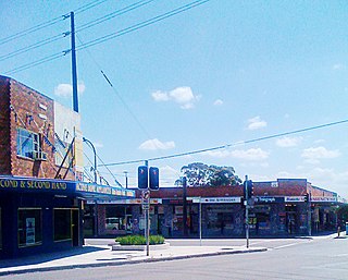
Fairfield is a suburb of South Western Sydney, in the state of New South Wales, Australia. Being in the centre of the Cumberland Plain, Fairfield is located 30 kilometres (19 mi) west of the Sydney central business district and is the administrative heart of the Fairfield City Council – despite a very small portion of it belonging to the Cumberland Council. Fairfield supports a mixture of commercial and residential developments, mostly characterised by medium-density buildings and some new high-rise apartments.

Acacia Gardens is a suburb of Sydney, in the state of New South Wales, Australia, 40 kilometres north-west of the Sydney central business district, in the local government area of the City of Blacktown. Acacia Gardens is part of the Greater Western Sydney region.
Yennora is a suburb of Sydney in the state of New South Wales, Australia, 29 kilometres west of the Sydney central business district. The residential part of the suburb is primarily in the local government area of the City of Fairfield, although the industrial area in west is a part of Cumberland Council. It is part of the Greater Western Sydney region.

Villawood, a suburb of local government areas City of Canterbury-Bankstown and City of Fairfield, is 27 kilometres west of the Sydney central business district, in the state of New South Wales, Australia.

Villawood railway station is located on the Main South line, serving the Sydney suburb of Villawood. It is served by Sydney Trains T3 Bankstown line services.

Smithfield is a suburb of Sydney, in the state of New South Wales, Australia. Smithfield is located 31 kilometres (19 mi) west of the Sydney central business district, in the local government areas of the City of Fairfield and Cumberland Council. Located in the Greater Western Sydney region, the suburb is one of the largest in Fairfield City by area.

Old Guildford is a suburb of Sydney, in the state of New South Wales, Australia 28 kilometres west of the Sydney central business district, in the local government area of the City of Fairfield. It is part of the Greater Western Sydney region.
Berowra Heights is an outer suburb of Northern Sydney, in the state of New South Wales, Australia 39 kilometres north of the Sydney central business district, in the local government area of Hornsby Shire. Berowra Heights is north-west of the suburb of Berowra and east of Berowra Waters.
Bonnyrigg Heights is a suburb of Sydney, in New South Wales, Australia. Its name originates from Bonnyrigg, Midlothian, Scotland. Bonnyrigg Heights is located on the traditional indigenous lands of the Dharug Nation.
Bossley Park is a suburb of Sydney, in the state of New South Wales, Australia. Bossley Park is located 36 kilometres west of the Sydney central business district in the local government area of the City of Fairfield. Bossley Park is part of the Greater Western Sydney region. The suburb is most well known for being an ethnic enclave of Assyrian and other Iraqi ethnic groups living in Sydney.
Fairfield West is a suburb of Sydney, in the state of New South Wales, Australia. Fairfield West is located 27 kilometres west of the Sydney central business district in the local government area of the City of Fairfield. Fairfield West is part of the Greater Western Sydney region.

Guildford West is a suburb of Sydney, in the state of New South Wales, Australia that is located 26 kilometres west of the Sydney central business district, in the local government area of the Cumberland City Council and is part of the Greater Western Sydney region. Guildford West shares the postcode of 2161 with the separate suburbs of Guildford and Old Guildford.

Fairfield East is a suburb of Sydney, in the state of New South Wales, Australia. Fairfield East is located 27 kilometres (17 mi) west of the Sydney central business district in the local government area of the City of Fairfield. Fairfield East is part of the Greater Western Sydney region. Fairfield East shares the postcode of 2165 with nearby suburbs of Fairfield, Fairfield Heights and Fairfield West.

Fairfield is an electoral district of the Legislative Assembly of the Australian state of New South Wales in Sydney's West. Fairfield has historically been one of the safest Labor seats in New South Wales and is considered a part of Labor's heartland in Western Sydney. It is currently represented by David Saliba of the Labor Party, who was elected at the 2023 New South Wales state election.
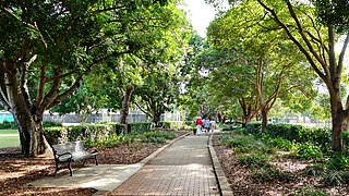
Fairfield Park Precinct, or Fairfield Park, is an urban park situated in the western suburbs of Sydney, New South Wales, Australia. Situated to the south of Fairfield CBD, the park contains an open grassland, bushland, picnic spots, playgrounds, indoor and outdoor sport facilities, and recreational areas within the vicinity of native plants, such as eucalyptus trees.
The Lennox River is the proposed name for a waterway located in Sydney's South-Western Suburbs. The existing waterway is the tidal reach of Prospect Creek, a tributary of the Georges River. A proposal has been made to upgrade and reclassify the waterway as a 'river'. The proposed river would be 6.5 kilometres (4 mi) long, starting at the confluence of Orphan School Creek and Prospect Creek at Fairfield and flowing to the Georges River emptying into Dhurawal Bay at Garrison Point.

