The Sahara desert, as defined by the World Wide Fund for Nature (WWF), includes the hyper-arid center of the Sahara, between latitudes 18° N and 30° N. It is one of several desert and xeric shrubland ecoregions that cover the northern portion of the African continent.
The Global 200 is the list of ecoregions identified by the World Wide Fund for Nature (WWF), the global conservation organization, as priorities for conservation. According to WWF, an ecoregion is defined as a "relatively large unit of land or water containing a characteristic set of natural communities that share a large majority of their species dynamics, and environmental conditions". For example, based on their levels of endemism, Madagascar gets multiple listings, ancient Lake Baikal gets one, and the North American Great Lakes get none.

The Caspian Depression or Pricaspian/Peri-Caspian Depression/Lowland is a low-lying flatland region encompassing the northern part of the Caspian Sea, the largest enclosed body of water on Earth. It is the larger northern part of the wider Aral-Caspian Depression around the Aral and Caspian Seas.

Chornye Zemli Nature Reserve (also) is a Russian 'zapovednik'. The name in Russian means "Black Lands". The main part of the reserve is located in the Caspian Depression, northwest of the Caspian Sea. It was originally created in 1990 to protect the saiga antelope. In the meantime the economy of Kalmykia collapsed and the numbers of saiga have crashed due to poaching for meat and horns and desertification caused by overgrazing by domestic animals. The reserve also has colonies of egrets, cormorants, and rare pelicans. The reserve is situated in the Chernozemelsky District of Republic of Kalmykia. It was created in 1990, and covers 1,219 km² in two locations, with a 900 km² buffer zone.

Astrakhan Nature Reserve is a Russian 'zapovednik' covering an area including the islands and wetlands of the Volga Delta, where the Volga River enters the northwest sector of the Caspian Sea. The landscape is one of extensive reeds, cattails and willows and is an important nesting area for waterfowl and wading birds. The areas is rich in fish, with 50 species recorded, including beluga sturgeon. The reserve is situated in the Ikryaninsky District of Astrakhan Oblast. Since 1975, the territory has been part of a Ramsar wetlands site of international importance, and since 1984 it has been included in the World Network of Biosphere Reserves.

Bogdinsko-Baskunchakski Nature Reserve is a Russian 'zapovednik' in a semi-arid area around two notable features: Lake Baskunchak, Russia's largest undrained salt lake, and Big Bogdo Mountain, the highest point in the Caspian Depression and home to the "singing rocks". It is about halfway between Volgograd and Astrakhan, placing it about 200 km north of the Volga River Delta, where the river enters the Caspian Sea from the northwest. About 20 km east of the lake is the border with Kazakhstan. Baskunchak has been a source of salt to Russia for centuries. The reserve is an important site on the bird migration route between northern Siberia and wintering regions. The reserve is situated in the Akhtubinsky District of Astrakhan Oblast.

Rostov Nature Reserve is a Russian 'zapovednik' that protects a variety of sensitive southern European steppe wetlands, the largest herd of wild horses in Europe, and also wetland habitat for birds. The protected areas are divided into five sections that cover the waters of Lake Manych-Gudilo, islands in that lake, surrounding steppe and shore lands. The reserve is situated in the Orlovsky District, of Rostov Oblast, about 100 km northeast of Rostov-on-Don. It is part of a Ramsar Wetland site of international importance.
The wildlife of Turkmenistan is the flora and fauna of Turkmenistan, and the natural habitats in which they live. Turkmenistan is a country in Central Asia to the east of the Caspian Sea. Two thirds of the country is hot dry plains and desert, and the rest is more mountainous. Very little rain falls in summer and the chief precipitation occurs in the southern part of the country in the winter and spring. The Caspian coast has milder winters.

Dagestan Nature Reserve is a Russian 'zapovednik' that protects an area of sand dunes and ridges on the northwest coast of the Caspian Sea in the southeast of European Russia. The reserve, a wintering place for migratory birds, is the richest nature reserve in Russia in terms of the number of species - over 300 species have been recorded in the reserve, its buffer zones and subordinate reserves. The reserve is part of several "Important Bird and Biodiversity Areas" (IBAs). The Sarykum sand dune is the highest sand dune in Europe, at 262 m (860 ft). The reserve is situated in the Tarumovsky District of Dagestan.

Taymyr Nature Reserve is a Russian 'zapovednik' located in the northern lowlands of Siberia, on the Taimyr Peninsula, and on the coast of the Laptev Sea of the Arctic Ocean. The reserve includes the most northern forest of Dahurian larch in the world, and also the most northern mainland mountain range in the world. The protected area was established to protect the breeding grounds of the Red-breasted goose as well as the summer residences of wild reindeer and the biodiversity of the Lake Taymyr. The reserve is situated about 120 km east of the town of Norilsk, and 3,000 km northeast of Moscow, in the Taymyrsky Dolgano-Nenetsky District of Krasnoyarsk Krai. In 1995, the site was designated a UNESCO MAB Reserve. The reserve was formally established in 1979, and covers an area of 1,781,928 ha (6,880.06 sq mi).

Pryazovskyi National Nature Park is the second largest national park of Ukraine, covering the estuaries, coastal plains seaside landforms around the Molochna River estuary the Utlyuksky estuary, on the northwest coast of the Sea of Azov. The area is one of high biodiversity, protecting both steppe and aquatic habitats, and the unique transition zones in between. The wetlands support very large populations of nesting and migratory waterfowl. The park is crosses several administrative districts, including Pryazovske Raion, Melitopol Raion, Berdiansk Raion, and Yakymivka Raion in Zaporizhia Oblast

The Northwest Russian-Novaya Zemlya tundra ecoregion is an ecoregion on the north coast of European Russia. It covers the southern shores of the White Sea, the coast of the Barents Sea east to the Yamal Peninsula, the southern half of Novaya Zemlya, and numerous inlets and islands. The low tundra wetlands are important breeding grounds for waterfowl. The ecoregion is in the Palearctic realm, and the tundra biome. It has an area of 284,122 square kilometres (109,700 sq mi).
The Taimyr-Central Siberian tundra ecoregion is an ecoregion that broadly covers the Taymyr Peninsula in the Russian Far North. It ranges from the delta of the Yenisei River in the west, across the Taymyr Peninsula and Khatanga Gulf, to the Lena River delta in the east. The region is an important area for breeding birds. It is in the Palearctic realm in the tundra biome, and is mostly located in Taymyrsky Dolgano-Nenetsky District of Krasnoyarsk Krai. It has an area of 954,670 square kilometres (368,600 sq mi).

The Central Asian riparian woodlands ecoregion is spread out across the deserts and plains of central Asia between the Aral Sea and the mountains 2,000 kilometres (1,200 mi) to the east. The long narrow components of the ecoregion follow the large rivers fed by snowmelt, and provide critical habitat for migratory birds as they travel through the arid region. The vegetation is referred to as tugai, characterized by low tangles of trees and brush along the edges of the rivers and associated wetlands, and fed by groundwater instead of precipitation.

The Central Asian southern desert ecoregion is an arid but ecologically active region between the east coast of the Caspian Sea and steppes at the base of the mountains of central Asia. Most of Turkmenistan and eastern Uzbekistan is in this ecoregion. The winters are milder than in the cold desert to the north, and a large number of endemic species have adapted to living in the particular climate and soil of the region. As with sandy deserts in general, the region is notable for high numbers of endemic species of reptiles and insects.

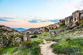
The Kopet Dag semi-desert ecoregion is a small ecoregion that crosses the border of southwestern Turkmenistan into northeastern Iran. It covers a transition zone between the deserts to the north and west, and the foothill steppes and woodlands in the higher Kopet Dag mountains to the east and the Alborz Mountains to the south. The terrain is mostly barren semi-desert and widespread 'takir', a type of seasonal salt flat or dried clay deposit in an interdune depression.

The Kopet Dag woodlands and forest steppe ecoregion coincides with the Kopet Dag mountains, straddling the southern border of Turkmenistan and the northeastern border of Iran. The region is one of high biodiversity, as it includes a full range of altitude zones, and variety of habitats included juniper-wooded slopes, montane grasslands, and tugay.

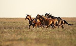
The Badghyz and Karabil semi-desert ecoregion covers the hills north of the central mountain ranges of Afghanistan, southeast Turkmenistan, and portions of Uzbekistan and Tajikistan. The landscape has been described as "savannah-like" and reminiscent of Africa, with desert sedges (Carex) and stands of wild pistachio trees. The area supports high biodiversity and a number of rare and endemic species, such as the endangered Turkmenian kulan (Equus hemionus kulan).

The Central Persian desert basins ecoregion covers the arid steppe and desert basins of central Iran, stretching into northwestern Afghanistan. The ecoregion extends over the Central Iranian Plateau, which is surrounded by mountain ranges and has no outlets to the sea. Much of the terrain is hot sand-and-gravel desert and large salt flats. The vegetation includes many specialized species of halophytes (salt-tolerant), xerophytes (drought-tolerant), and psammophile (sand-loving) plants.
The Azerbaijan shrub desert and steppe is a deserts and xeric shrublands ecoregion in western Asia. It lies in the lowlands west of the Caspian Sea, and covers portions of Azerbaijan, Georgia, and Iran.