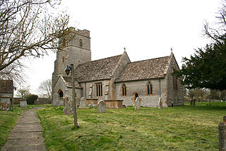
Babcary is a village and civil parish in Somerset, England, about 5 miles (8.0 km) east of Somerton and 6 miles (9.7 km) southwest of Castle Cary, in the South Somerset district. The village has a population of 248. It lies close to the River Cary and the A37. The parish includes the hamlet of Foddington.

RAF Locking was a Royal Air Force station at Locking just outside Weston-super-Mare in Somerset, England.

Loughor Castle is a ruined, medieval fortification located in the town of Loughor, Wales. The castle was built around 1106 by the Anglo-Norman lord Henry de Beaumont, during the Norman invasion of Wales. The site overlooked the River Loughor and controlled a strategic road and ford running across the Gower Peninsula. The castle was designed as an oval ringwork, probably topped by wicker fence defences, and reused the remains of the former Roman fort of Leucarum.
Watch Hill Castle is an early medieval motte-and-bailey on the border of Bowdon and Dunham Massey, England. It is a scheduled monument. As the only Scheduled Ancient Monument in Trafford, it is arguably the most important archaeological site in the borough. The castle is located north of the River Bollin and south of a deep ravine.

Burrow Mump is a hill and historic site overlooking Southlake Moor in the village of Burrowbridge within the English county of Somerset. It is a scheduled monument, with the ruined church on top of the hill a Grade II listed building.

Stowey Castle was a Norman motte-and-bailey castle, built in the 11th century, in the village of Nether Stowey on the Quantock Hills in Somerset, England. It has been designated as a Scheduled Ancient Monument.

The Yarn Market in Dunster, Somerset, England was built in the early 17th century. It has been designated as a Grade I listed building and scheduled monument. Dunster was an important market place in the Middle Ages particularly following the construction of Dunster Castle and the establishment of the Priory Church of St George.
Drove Cottage Henge is a scheduled monument in the Priddy parish of Somerset, England. It is located 370 metres (1,210 ft) north of Drove Cottage. The site is a ceremonial Neolithic location. Since this henge is one of only around 80 henges throughout England, it is considered to be nationally important.

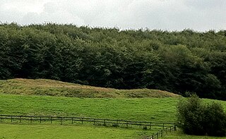
Wimble Toot is a burial mound or, possibly, a motte built near the village of Babcary, Somerset, England. It is a scheduled ancient monument with a list entry number of 1015279.
Hales Castle was a medieval castle that once stood overlooking the town of Frome in the Mendip district of Somerset, England. It has been scheduled as an ancient monument.
Down End Castle, also known as Downend Castle, Chisley Mount or Chidley Mount, was a motte-and-bailey castle at Down End, north of Dunball in the parish of Puriton, Somerset, England. It has been designated as a Scheduled Ancient Monument.
Walter of Douai was a Norman knight, probably at the Battle of Hastings, and a major landowner in South West England after the Norman Conquest, being feudal baron of Bampton in Devon and of Castle Cary in Somerset. He is given various names and titles in different sources including: Walter de Douai. Douai is sometimes written as Dowai. He has also been called Gautier de Douai and later Walter the Fleming.
The Dane John Mound, also known as the Dane John Gardens, is a former Roman cemetery in the city of Canterbury, Kent. It was converted into a motte-and-bailey castle in the 11th century, and turned into a civic park between 1790 and 1803.

Sand Point in Somerset, England, is the peninsula stretching out from Middle Hope, an 84.1-hectare (208-acre) biological and geological Site of Special Scientific Interest. It lies to the north of the village of Kewstoke, and the stretch of coastline called Sand Bay north of the town of Weston-super-Mare. On a clear day it commands views over Flat Holm, of the Bristol Channel, South Wales, Clevedon, the Second Severn Crossing and the Severn Bridge. A line drawn between Sand Point and Lavernock Point in South Wales marks the lower limit of the Severn Estuary and the start of the Bristol Channel.

There are over 670 scheduled monuments in the ceremonial county of Somerset in South West England. The county consists of a non-metropolitan county, administered by Somerset County Council, which is divided into five districts, and two unitary authorities. The districts of Somerset are West Somerset, South Somerset, Taunton Deane, Mendip and Sedgemoor. The two administratively independent unitary authorities, which were established on 1 April 1996 following the breakup of the county of Avon, are North Somerset and Bath and North East Somerset. These unitary authorities include areas that were once part of Somerset before the creation of Avon in 1974.

Bury Castle near Brompton Regis in the English county of Somerset was an Iron Age univallate hillfort which was reused with the creation of a motte after the Norman Conquest. It has been scheduled as an ancient monument.

