
Brackley is a market town and civil parish in West Northamptonshire, England, bordering Oxfordshire and Buckinghamshire, 19 miles (31 km) from Oxford and 22 miles (35 km) from Northampton. Historically a market town based on the wool and lace trade, it was built on the intersecting trade routes between London, Birmingham, the Midlands, Cambridge and Oxford. Brackley is close to Silverstone and home to the Mercedes AMG Petronas F1 Team.
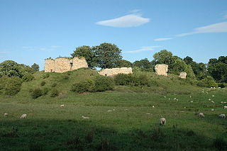
Castlethorpe is a village and civil parish with a population of about 1000 in the Borough of Milton Keynes, Buckinghamshire, England. It is about 3 miles (4.8 km) north-east of Stony Stratford, 4 miles (6.4 km) north-west of Newport Pagnell and 7 miles (11 km) north of Central Milton Keynes. It is separated from the county of Northamptonshire by the River Tove.
Hanslope is a village and civil parish in the Borough of Milton Keynes, Buckinghamshire, England. The village is about 4 miles (6.4 km) west northwest of Newport Pagnell, about 4 miles (6.4 km) north of Stony Stratford and 8 miles (13 km) north of Central Milton Keynes. The northern parish boundary is part of the county boundary with Northamptonshire.

Wing, known in antiquated times as Wyng, is a village and civil parish in east Buckinghamshire, England. The village is on the main A418 road between Aylesbury and Leighton Buzzard. It is about 8 miles (13 km) north-east of Aylesbury, 3 miles (5 km) west of Leighton Buzzard, and 12 miles (19 km) south of Milton Keynes.

Wolverton is a constituent town of Milton Keynes, England. It is located at the northern edge of Milton Keynes, beside the West Coast Main Line, the Grand Union Canal and the river Great Ouse. It is the administrative seat of Wolverton and Greenleys civil parish.

Pleshey is a historic village and civil parish in the Chelmsford district, in the county of Essex, England, 6 miles (10 km) north-west of Chelmsford. The Normans built a motte and bailey in the late 11th century; the motte is one of the largest of its kind in Great Britain. It was besieged several times during the Barons' Wars and rebellions in the 13th centuries.

Sir Falkes de Bréauté was an Anglo-Norman soldier who earned high office by loyally serving first King John and later King Henry III in the First Barons' War. He played a key role in the Battle of Lincoln Fair in 1217. He attempted to rival Hubert de Burgh, and as a result fell from power in 1224. His "heraldic device" is now popularly said to have been a griffin, although his coat of arms as depicted by Matthew Paris in his Chronica Majora was Gules, a cinquefoil argent.

Bedford Castle was a large medieval castle in Bedford, England. Built after 1100 by Henry I, the castle played a prominent part in both the civil war of the Anarchy and the First Barons' War. The castle was significantly extended in stone, although the final plan of the castle remains uncertain. Henry III of England besieged the castle in 1224 following a disagreement with Falkes de Breauté; the siege lasted eight weeks and involved an army of as many as 2,700 soldiers with equipment drawn from across England. After the surrender of the castle, the king ordered its destruction (slighting).
Caus Castle is a ruin of a hill fort and medieval castle in the civil parish of Westbury in the English county of Shropshire. It is situated up on the eastern foothills of the Long Mountain guarding the route from Shrewsbury, Shropshire to Montgomery, Powys on the border between England and Wales. It was destroyed during the English Civil War and has been in ruins since.
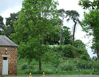
Bury Mount Motte is the remains of an earthwork motte and bailey fortification or ancient castle, and has been designated a Scheduled Ancient Monument. The Motte probably dates back to the 11th Century when it was a Norman fortification but over time was subject to neglect.
Anstey Castle was in the village of Anstey, Hertfordshire. It was a 12th-century stone motte and bailey fortress that, according to tradition, was founded by Eustace II, Count of Boulogne. It was either him, or one of his immediate progeny who established the first earthwork castle here. The castle had most probably been in existence for some time when the estate was acquired by Geoffrey de Mandeville, for he sought to strengthen his estate in the surrounding valley. It passed into the hands of the de Anstey family in the middle of the 12th century and was strengthened during the First Barons' War of 1215–1216 by Nicholas de Anstey, an opponent of King John, fighting for the barons. After the war ended de Anstey was commanded in 1218 to destroy the castle, with only those parts to remain that had been built before the war. The material from this demolition was supposed to be used in order to repair the nearby church, therefore the crest and shield from the castle feature in the church graffiti.

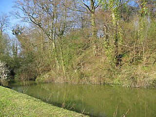
Ashton Keynes Castle was in the village of Ashton Keynes, near to the town of Cricklade in Wiltshire, England. It is also known as Hall's Close, while locals call it The Battlefield. The scheduled monument consists of a ringwork and bailey 100 metres (330 ft) west of Kentend Farm.

Deddington Castle is an extensive earthwork in the village of Deddington, Oxfordshire, all that remains of an 11th-century motte-and-bailey castle, with only the earth ramparts and mound now visible.
Mitford Castle is an English castle dating from the end of the 11th century and located at Mitford, Northumberland. It is a Scheduled Ancient Monument and a Grade I listed building, enlisted on 20 October 1969. The castle is also officially on the Buildings at Risk Register. The Norman motte and bailey castle stands on a small prominence, a somewhat elliptical mound, above the River Wansbeck. The selected building site allowed for the natural hill to be scarped and ditched, producing the motte.

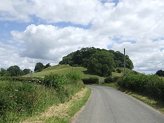
Pleshey Castle is a man-made motte and bailey castle in Pleshey in Essex, England. It was built in the 11th century and it is one of the best preserved motte and bailey castles in England.

While there are many castles in South Yorkshire, the majority are manor houses and motte-and-bailey which were commonly found in England after the Norman Conquest.

Stogursey Castle is a medieval castle in Somerset, England. Most of the site is in ruins, but there is a thatched gatehouse used for holiday rental by the Landmark Trust.
William III de Beauchamp of Elmley Castle in Worcestershire, was an English Baron and hereditary Sheriff of Worcestershire.

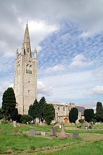
Church of St Simon and St Jude Church is a late 12th century parish church in Castlethorpe, Borough of Milton Keynes, Buckinghamshire, England. It was formerly a chapelry of Hanslope. Of note is the Norman font with figures at the corners. It was designated a Grade I listed building in 1966.
