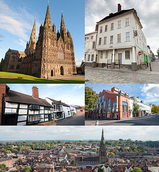
Lichfield is a cathedral city and civil parish in Staffordshire, England. Lichfield is situated roughly 18 miles (29 km) south-east of the county town of Stafford, 8.1 miles (13.0 km) south-east of Rugeley, 9 miles (14 km) north-east of Walsall, 7.9 miles (12.7 km) north-west of Tamworth and 13 miles (21 km) south-west of Burton Upon Trent. At the time of the 2011 Census, the population was estimated at 32,219 and the wider Lichfield District at 100,700.

Lichfield Cathedral is an Anglican cathedral in Lichfield, Staffordshire, England, one of only three cathedrals in the United Kingdom with three spires, and the only medieval one of the three. It is the cathedral of the Diocese of Lichfield, which covers Staffordshire, much of Shropshire, and parts of the Black Country and West Midlands. It is the seat of the Bishop of Lichfield, currently Michael Ipgrave, who was appointed in 2016. It is a Grade I listed building.
Eccleshall Castle is located in Eccleshall, Staffordshire, England. It was originally built in the 13th century. It is a Scheduled Ancient Monument and a Grade II* listed building.
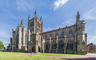
Hereford Cathedral is the cathedral church of the Anglican Diocese of Hereford in Hereford, England.

Whittington is a village and civil parish which lies approximately 3 miles south east of Lichfield, in the Lichfield district of Staffordshire, England. According to the 2001 census it had a population of 2,591, increasing to 2,603 at the 2011 Census. The parish council is a joint one with Fisherwick. The Coventry Canal borders the village to the north and east.

Walter Langton of Castle Ashby in Northamptonshire, was Bishop of Coventry and Lichfield and Treasurer of England. The life of Langton was strongly influenced by his uncle William Langton, Archbishop of York-elect, by Robert Burnell, Lord Chancellor of England and then by the years in which he served King Edward I. Lichfield Cathedral was improved and enriched at his expense.
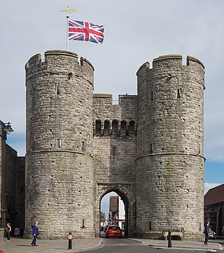
The Westgate is a medieval gatehouse in Canterbury, Kent, England. This 60-foot (18 m) high western gate of the city wall is the largest surviving city gate in England. Built of Kentish ragstone around 1379, it is the last survivor of Canterbury's seven medieval gates, still well-preserved and one of the city's most distinctive landmarks. The road still passes between its drum towers. This scheduled monument and Grade I listed building houses the West Gate Towers Museum as well as a series of historically themed escape rooms.

English Gothic is an architectural style that flourished from the late 12th until the mid-17th century. The style was most prominently used in the construction of cathedrals and churches. Gothic architecture's defining features are pointed arches, rib vaults, buttresses, and extensive use of stained glass. Combined, these features allowed the creation of buildings of unprecedented height and grandeur, filled with light from large stained glass windows. Important examples include Westminster Abbey, Canterbury Cathedral and Salisbury Cathedral. The Gothic style endured in England much longer than in Continental Europe.

St John the Baptist's Church is the former cathedral of Chester, Cheshire, England during the Early Middle Ages. The church, which was first founded in the late 7th Century by the Anglo Saxons, is outside Chester's city walls on a cliff above the north bank of the River Dee. It is now considered to be the best example of 11th–12th century church architecture in Cheshire, and was once the seat of the Bishop of Lichfield from 1075 to 1095.

Vicars' Close, in Wells, Somerset, England, is claimed to be the oldest purely residential street with original buildings surviving intact in Europe. John Julius Norwich called it "that rarest of survivals, a planned street of the mid-14th century". It comprises numerous Grade I listed buildings, comprising 27 residences, built for Bishop Ralph of Shrewsbury, a chapel and library at the north end, and a hall at the south end, over an arched gate. It is connected at its southern end to the cathedral by a walkway over Chain Gate.

St Mary the Virgin is a 13th-century Anglican parish church in Northolt, London Borough of Ealing. It is on a slope shared with Belvue Park, the site of a 15th-century manor house — both overlooked the old village of Northolt. It is one of London's smallest churches, its nave measuring 15 yards (14 m) by 8 yards (7.3 m). The church was built around 1290 and was expanded over the centuries, with the chancel being added in 1521, the spired bell tower in the 16th century, and a gallery at the west end of the church in 1703. Twin buttresses were erected against the west wall around 1718 to alleviate concerns that the church could slip down the hill. The internal beams are original and the bells date from the 17th century. The church was constructed from a variety of materials; the nave incorporates clunch, flint and ironstone, and the mouldings of the doors and windows are made from Reigate Stone.

The Church of St Chad is a parish church in the area of Stowe in the north of the city of Lichfield, Staffordshire, in the United Kingdom. It is a Grade II* Listed Building. The church is located to the north of Stowe Pool on St Chad's Road. The current building dates back to the 12th century although extensive restorations and additions have been made in the centuries since.

The Hospital of St John Baptist without the Barrs is a building with an adjacent chapel in the city of Lichfield, Staffordshire, England. It is a Grade I listed building.

St Mary's Church is a city centre church in Lichfield, Staffordshire in the United Kingdom, located on the south side of the market square. A church is reputed to have been on the present site since at least 1150 but the current building dates from 1870 and is a Grade II* listed building. The church was remodelled in the early 1980s and again in 1997-1999 and now serves a variety of purposes including Lichfield Library and Tourist Information on the ground floor, and on the top floor, The Hub at St Mary's is now home to a speciality coffee shop, art gallery, treasury exhibition and performing arts space.
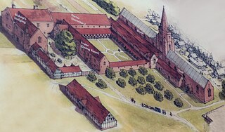
The Franciscan Friary was once a large estate located on the west side of Lichfield city centre in Staffordshire. The estate was built and inhabited by the Franciscan Friars from 1237. At one time the estate consisted of a large church, a cloister, dormitory lodge and a refectory building as well as many other domestic dwellings.

Minster Pool is a reservoir located between Bird Street and Dam Street in the heart of the city of Lichfield, Staffordshire in the United Kingdom. The pool lies directly south of Lichfield Cathedral and historically has been important to the defence of the Cathedral Close. The pool was originally formed in the 11th century when a boggy stream was dammed at its eastern end to drive a mill on Dam Street. The pool was used as a mill pond and fishery until 1856 when the mill was demolished; it has since been retained for public amenity.

The Bishop's Palace is a 17th-century building situated in the north-east corner of the Cathedral Close in Lichfield, Staffordshire in England.
Colan Church also known as St Colan Church is a 13th-century church in Colan, mid-Cornwall, UK. Dedicated to St Colanus, it became a Grade I listed building in 1967. The vicars of St Columb Minor have served the church since the middle of the 20th century.

Holy Trinity Church in Eccleshall, Staffordshire, England, is a Grade I listed Anglican church.
St Mary's Church is a parish church of the Church of England in Rolleston on Dove, Staffordshire. Parts of the structure date to 1130, though it was extensively renovated in 1892. It is unusual in having the main entrance door on the north side, with the southern entrance reserved for members of the Mosley family, local landowners and key donors to the church. The church features stained glass windows dating to the medieval period and others by Victorian designer Charles Eamer Kempe. The tower houses eight bells, one dating to 1586. The church is grade I listed and there are associated grade II listings for churchyard railings, a memorial, the lychgate and a former church grammar school. The lychgate, by Lincolnshire architect Cecil Greenwood Hare, also functions as a war memorial.

