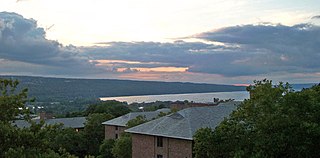
Cayuga Lake (,,) is the longest of central New York's glacial Finger Lakes, and is the second largest in surface area and second largest in volume. It is just under 39 miles (63 km) long. Its average width is 1.7 miles (2.8 km), and it is 3.5 mi wide (5.6 km) at its widest point, near Aurora. It is approximately 435 ft deep (133 m) at its deepest point, and has over 95 miles (153 km) of shoreline.

The Niagara River is a river that flows north from Lake Erie to Lake Ontario. It forms part of the border between the province of Ontario in Canada and the state of New York in the United States. There are differing theories as to the origin of the river's name. According to Iroquoian scholar Bruce Trigger, Niagara is derived from the name given to a branch of the locally residing native Neutral Confederacy, who are described as being called the Niagagarega people on several late-17th-century French maps of the area. According to George R. Stewart, it comes from the name of an Iroquois town called Ongniaahra, meaning "point of land cut in two".

Niagara Falls is a city in Niagara County, New York, United States. As of the 2020 census, the city had a total population of 48,671. It is adjacent to the Niagara River, across from the city of Niagara Falls, Ontario, and named after the famed Niagara Falls which they share. The city is within the Buffalo–Niagara Falls metropolitan area and the Western New York region.

René-Robert Cavelier, Sieur de La Salle, was a 17th-century French explorer and fur trader in North America. He explored the Great Lakes region of the United States and Canada, and the Mississippi River. He is best known for an early 1682 expedition in which he canoed the lower Mississippi River from the mouth of the Illinois River to the Gulf of Mexico; there, on 9 April 1682, he claimed the Mississippi River basin for France after giving it the name La Louisiane. One source states that "he acquired for France the most fertile half of the North American continent". A later ill-fated expedition to the Gulf coast of Mexico gave the United States a claim to Texas in the purchase of the Louisiana Territory from France in 1803. La Salle was assassinated in 1687 during that expedition.

The Mohawk River is a 149-mile-long (240 km) river in the U.S. state of New York. It is the largest tributary of the Hudson River. The Mohawk flows into the Hudson in Cohoes, New York, a few miles north of the city of Albany. The river is named for the Mohawk Nation of the Iroquois Confederacy. It is a major waterway in north-central New York. In the early 19th century, the river's east-west valley provided the setting and water for development of the Erie Canal, as a key to developing New York. The largest tributary, the Schoharie Creek, accounts for over one quarter (26.83%) of the Mohawk River's watershed. Another main tributary is the West Canada Creek, which makes up for 16.33% of the Mohawk's watershed.

Father Louis Hennepin, O.F.M. baptized Antoine, was a Belgian Roman Catholic priest and missionary of the Franciscan Recollet order and an explorer of the interior of North America.

Le Griffon was a sailing vessel built by French explorer and fur trader René-Robert Cavelier, Sieur de La Salle in the Niagara area of Canada in 1679.

The Buffalo River drains a 447-square-mile (1,160 km2) watershed in Western New York state, emptying into the eastern end of Lake Erie at the City of Buffalo. The river has three tributaries: Cayuga Creek, Buffalo Creek, and Cazenovia Creek.

The Oswego River is a river in upstate New York in the United States. It is the second-largest river flowing into Lake Ontario. James Fenimore Cooper’s novel The Pathfinder, or The Inland Sea is set in the Oswego River valley.

The Seneca River flows 61.6 miles (99.1 km) through the Finger Lakes region of Upstate New York in the United States. The main tributary of the Oswego River – the second-largest river flowing into Lake Ontario – the Seneca drains 3,468 square miles (8,980 km2) in parts of fourteen New York counties. The Seneca flows generally east, and is wide and deep with a gentle gradient. Much of the river has been channelized to form part of the Erie Canal.
Fort Conti was built in early 1679 at the mouth of the Niagara River on Lake Ontario as a post for the French explorer René-Robert Cavelier, Sieur de La Salle. Because of the fort's location, the French hoped to control the fur trade in the lower Great Lakes. The fort was named after Louis Armand I, Prince of Conti, the patron of La Salle's lieutenant, Henri de Tonti.
Cayuga Creek is a small stream in western New York, United States, with stretches in both Erie County and Wyoming County. The creek enters Buffalo Creek in the northwest corner of the Town of West Seneca in Erie County, just upstream from the New York State Thruway crossing. At that point, Buffalo Creek becomes the Buffalo River and flows into Lake Erie near Buffalo, New York.
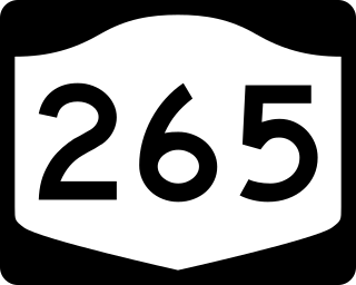
New York State Route 265 (NY 265) is a 19.75-mile (31.78 km) long state highway located in the western part of New York in the United States. NY 265 is a north–south route that roughly parallels the western parts of the Niagara River in Erie County and Niagara County. For much of its southern course, it is more frequently referred to by its longtime name, Military Road, which dates back to 1801 as a road to connect the city of Black Rock and Fort Niagara near Lake Ontario.

New York State Route 384 (NY 384) is a state highway in Western New York in the United States. It is a north–south route extending from the city of Buffalo, Erie County to the city of Niagara Falls, Niagara County, and is one of several routes directly connecting the two cities. The southern terminus of the route is at NY 5 in downtown Buffalo. NY 384's northern terminus is at the Rainbow Bridge in downtown Niagara Falls. Through its entire course in Erie County, it is known as Delaware Avenue for the street it follows in the city. In Niagara County, NY 384 follows the Niagara River and is named River Road and Buffalo Avenue.
The LaSalle Expressway is a 2.62-mile (4.22 km) freeway in Niagara County, New York, in the United States. It begins near the North Grand Island Bridge at an interchange with Interstate 190 (I-190) in Niagara Falls and ends just south of the Niagara Falls International Airport at Williams Road (NY 952V) in Wheatfield. The LaSalle Expressway is part of New York State Route 951A (NY 951A), an unsigned reference route; the other, 0.42-mile (0.68 km) portion is located along Niagara Street between the Rainbow Bridge and Fifth Street in downtown Niagara Falls. Most of this portion, which is not connected to the LaSalle Expressway, is also part of the signed NY 384.

Wappinger Creek is a 41.7-mile-long (67.1 km) creek which runs from Thompson Pond to the Hudson River at New Hamburg in Dutchess County, New York, United States. It is the longest creek in Dutchess County, with the largest watershed in the county.
Macomb Mountain is a mountain located in Essex County, New York. The mountain is named after Maj. Gen. Alexander Macomb (1782–1841), who won acclaim during the War of 1812 at the Battle of Plattsburgh, and served as Commanding General of the United States Army (1828–1841).

Grandyle Village is a hamlet and census-designated place (CDP) in the town of Grand Island in Erie County, New York, United States. As of the 2010 census, it had a population of 4,629.
Queen of the Lakes is the unofficial but widely recognized title given to the longest vessel active on the Great Lakes of the United States and Canada. A number of vessels, mostly lake freighters, have been known by the title.


