
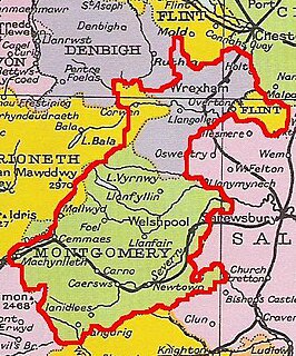
The Kingdom of Powys was a Welsh successor state, petty kingdom and principality that emerged during the Middle Ages following the end of Roman rule in Britain. It very roughly covered the top two thirds of the modern county of Powys and part of today's English West Midlands. More precisely, and based on the Romano-British tribal lands of the Ordovices in the west and the Cornovii in the east, its boundaries originally extended from the Cambrian Mountains in the west to include the modern West Midlands region of England in the east. The fertile river valleys of the Severn and Tern are found here, and this region is referred to in later Welsh literature as "the Paradise of Powys".
Cefnllys was a medieval town in Radnorshire in central Wales. Only St Michael's Church remains standing, with mounds indicating the remains of other buildings existing before the decline of the town in the 19th century. Close by on the hill known as Castle Rock are the remains of what is known as Cefnllys Castle. Almost encircling the hill, church and remains of the town is the River Ithon which continues to Llandrindod Wells a little over a mile away.
Madog ap Llywelyn was the leader of the Welsh revolt of 1294–95 against English rule. The revolt was surpassed in longevity only by the revolt of Owain Glyndŵr in the 15th century. Madog belonged to a junior branch of the House of Aberffraw and was a distant relation of Llywelyn ap Gruffudd, the last recognised native Prince of Wales.
Madog ap Maredudd was the last Prince of the entire Kingdom of Powys, Wales and for a time held the Fitzalan Lordship of Oswestry.

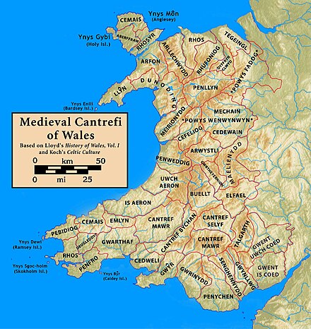
Powys Fadog was the northern portion of the former princely realm of Powys, which split in two following the death of Madog ap Maredudd in 1160. The realm was divided under Welsh law, with Madog's nephew Owain Cyfeiliog inheriting the south and his son Gruffydd Maelor I, who inherited the north.

Maelienydd, sometimes spelt Maeliennydd, was a cantref and lordship in east central Wales covering the area from the River Teme to Radnor Forest and the area around Llandrindod Wells. The area, which is mainly upland, is now in Powys. During the Middle Ages it was part of the region known as Rhwng Gwy a Hafren.

Cwmhir Abbey, near Llandrindod Wells in Powys, is a Welsh Cistercian monastery founded in 1176 by Cadwallon ap Madog. A spurious tale was later recorded that the abbey was founded in 1143 by Meredudd ap Maelgwn at Ty-faenor, and then refounded at the present location near the village of Abbeycwmhir in 1176. There does appear to be a site movement from Ty-faenor, but Maredudd ap Maelgwn was prince of Maelienydd in 1215 under Prince Llywelyn ab Iorwerth of Gwynedd, who then controlled the district. The later charter to the abbey in 1215 caused the confusion and led to the belief that Maredudd had founded the abbey in 1143.

Gwrtheyrnion or Gwerthrynion was a commote in medieval Wales, located in Mid Wales on the north side of the River Wye; its historical centre was Rhayader. It is said to have taken its name from the legendary king Vortigern. For most of the medieval era, it was associated with the cantref of Buellt and then Elfael, small regional kingdoms whose rulers operated independently of other powers. In the Norman era, like the rest of the region between Wye and Severn it came to be dominated by Marcher Lordships.
Rhwng Gwy a Hafren was a region of medieval Wales, located in the Welsh Marches between Powys to the north and Brycheiniog to the south. It was bounded by the rivers Wye and Severn. It covered about the same territory as Radnorshire, now part of the county of Powys. The region first came into its own in the 9th or 10th centuries, when it was ruled by leaders who operated independently of the surrounding kingdoms. After the Norman invasion, it comprised the central part of the Welsh Marches and was the site of frequent struggles between Welsh and Norman forces.
Cadwallon ap Madog was the son of Madog ab Idnerth who had died in 1140, while Idnerth was a grandson of Elystan Glodrydd who had died in around 1010 and had founded a dynasty in the Middle Marches of Wales, in the area known as Rhwng Gwy a Hafren.
Elfael was one of a number of Welsh cantrefi occupying the region between the River Wye and river Severn, known as Rhwng Gwy a Hafren, in the early Middle Ages. It was divided into two commotes, Is Mynydd and Uwch Mynydd, separated by the chain of hills above Aberedw. In the late medieval period, it was a marcher lordship. However, after the Laws in Wales Act of 1535, it was one of the territorial units which went to make up the county of Radnorshire in 1536.
The House of Mathrafal began as a cadet branch of the House of Dinefwr, taking their name from Mathrafal Castle, their principal seat and effective capital. Although their fortunes rose and fell over the generations, they are primarily remembered as kings of Powys in central Wales.

Cyfeiliog was a medieval commote in the cantref of Cynan of the Kingdom of Powys. Cynan also contained the commote of Mawddwy. Other sources refer to Cyfeiliog as a cantref in its own right, possibly as a result of Cynan being renamed for the largest commote within it.
Caereinion was a medieval cantref in the Kingdom of Powys, or possibly it was a commote (cwmwd) within a cantref called Llŷs Wynaf. It was divided into the manors of Uwch Coed and Is Coed.

Mochnant, a name translating as "the rapid stream", was a medieval cantref in the Kingdom of Powys.
Ystrad Marchell sometimes Strad Marchell was a medieval commote (cwmwd) in the cantref of Ystlyg in the Kingdom of Powys. It roughly coincides with the parish of Welshpool.
Ystlyg was a medieval cantref in the Kingdom of Powys. It lay at the east of the kingdom on the border with England. It consisted of the commotes (cymydau) of Deuddwr in the north, Ystrad Marchell in the centre, Llannerch Hudol in the south, and Y Gorddwr in the east beyond the River Severn and Offa's Dyke.
Penllyn was a medieval cantref originally in the Kingdom of Powys but annexed to the Kingdom of Gwynedd. It consisted of the commotes of Edeyrnion, Dinmael, Penllyn is Treweryn and Penllyn uwch Treweryn.
Deuddwr was a medieval commote (cwmwd) in the cantref of Ystlyg in the Kingdom of Powys.

Llanerchydol is a settlement on the A458 about 2 km west of the centre of Welshpool in the county of Powys in Wales. It is part of the community of Welshpool and also lends its name to an electoral ward.