
Cape Breton Island is an island on the Atlantic coast of North America and part of the province of Nova Scotia, Canada.
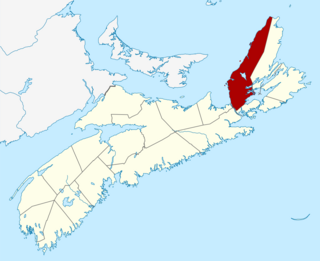
Inverness County is an historical county and census division of Nova Scotia, Canada. Local government is provided by the Municipality of the County of Inverness, the town of Port Hawkesbury and the Whycocomagh 2 Waycobah First Nation reserve.

Port Hood is an unincorporated place in the Municipality of the County of Inverness, Nova Scotia, Canada. It is an administrative centre and a service centre for the surrounding area. It is also the site of a registered historic place, Peter Smyth House.
The Cabot Trail is a scenic highway on Cape Breton Island in Nova Scotia, Canada. It is a 298 km (185 mi) loop around the northern tip of the island, passing along and through the Cape Breton Highlands and the Cape Breton Highlands National Park.

Baddeck is a village in northeastern Nova Scotia, Canada. It is situated in the centre of Cape Breton, approximately 6 km east of where the Baddeck River empties into Bras d'Or Lake.
Judique is an unincorporated place within the Municipality of the County of Inverness on Cape Breton Island, Nova Scotia, Canada. It is the site of the Celtic Music Interpretive Centre and a stop on the scenic Ceilidh Trail.

The Cape Breton Highlands, commonly called the Highlands, refer to a highland or mountainous plateau across the northern part of Cape Breton Island in the Canadian province of Nova Scotia.

Canadian Gaelic or Cape Breton Gaelic, often known in Canadian English simply as Gaelic, is a collective term for the dialects of Scottish Gaelic spoken in Atlantic Canada.
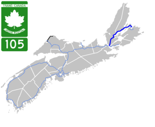
Highway 105 in Nova Scotia represents the Cape Breton Island leg of the Trans-Canada Highway. It runs from the Port Hastings Rotary just east of the Canso Causeway in Port Hastings to the Marine Atlantic ferry terminal in North Sydney, representing a distance of 142 kilometres (88 mi).

Trunk 19 is part of the Canadian province of Nova Scotia's system of trunk highways. The road runs from Port Hastings to a junction with the Cabot Trail at Margaree Forks on Cape Breton Island, a distance of 107 kilometres (66 mi). Most of the route is known as the Ceilidh Trail.
The Marine Drive is a designated scenic route along Nova Scotia's Eastern Shore. It closely follows the coast of the Atlantic Ocean and the Strait of Canso from the Canso Causeway to the junction of Route 322 and Highway 111 in Dartmouth.
The Lighthouse Route is a scenic roadway in the Canadian province of Nova Scotia. It follows the province's South Shore for 585 km (364 mi) from Halifax to Yarmouth.
The Marconi Trail is a scenic roadway in the Canadian province of Nova Scotia.
The Glooscap Trail is a scenic roadway in the Canadian province of Nova Scotia.
The Sunrise Trail is a scenic roadway in the Canadian province of Nova Scotia. It is located along the province's North Shore on the Northumberland Strait for 333 km (207 mi) from Amherst to the Canso Causeway.
The Bras d'Or Lakes Scenic Drive is a scenic roadway on Nova Scotia's Cape Breton Island. It extends around the perimeter of Bras d'Or Lake.
The Fleur-de-lis Trail is a scenic roadway located on Nova Scotia's Cape Breton Island. It is approximately 182 km (113 mi) long and runs along the southeastern part of the island through an Acadian region, with a 35 km (22 mi) spur route to and encircling Isle Madame, for a total distance of 217 km (135 mi).
Route 219 is a collector road approximately 20.3 km long in the Canadian province of Nova Scotia.
The Fundy Shore Scenic Drive is a scenic drive in the Canadian province of Nova Scotia. It located along the northeastern portion of the Bay of Fundy, following the Chignecto Peninsula which separates Chignecto Bay and Minas Basin, an area which contains the highest tidal range on the planet.
The Municipality of the County of Inverness is a county municipality on Cape Breton Island, Nova Scotia, Canada. It provides local government to about 17,000 residents of the historical county of the same name, except for the incorporated town of Port Hawkesbury and the Whycocomagh 2 Miꞌkmaq reserve, both of which are enclaves. Public services are provided in the areas of recreation, tourism, administration, finance, and public works.