| Cemaes | |
|---|---|
 | |
| History | |
| • Created | 1 April 1934 |
| • Abolished | 31 March 1974 |
| • Succeeded by | Preseli |
| Status | Rural District |
| • HQ | Cardigan |
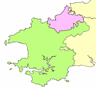
Cemaes Rural District was an administrative subdivision of Pembrokeshire, Wales from 1934 to 1974.
| Cemaes | |
|---|---|
| | |
| History | |
| • Created | 1 April 1934 |
| • Abolished | 31 March 1974 |
| • Succeeded by | Preseli |
| Status | Rural District |
| • HQ | Cardigan |
Cemaes Rural District was an administrative subdivision of Pembrokeshire, Wales from 1934 to 1974.
The district's name is that of its northernmost point, the promontory Cemaes Head, though it may also hark back to the Cantref of Cemais, which existed from Norman times, and as the Hundred of Cemais from the 16th century.
Cemaes Rural District was formed in 1934 by the amalgamation of St Dogmells Rural District and Llanfyrnach Rural District. The council was administered from Cardigan, outside its area. [1] [2]
The Council comprised councillors and a chairman, and its responsibilities included sanitary services, sewerage, refuse collection, maintaining local roads, cemeteries and parks, licensing of public entertainments, water supply and housing. It became a rating authority in 1925. Rural District Councils were administered by a number of committees and by appointed officers including a Clerk, Treasurer, Public Health Inspector, Housing Officer, Surveyor and Rating Officer. [1]
It was abolished in 1974, when it was absorbed into the Preseli District of Dyfed. [1]

Meirionnydd is a coastal and mountainous region of Wales. It has been a kingdom, a cantref, a district and, as Merionethshire, a county.
Mid Bedfordshire was, from 1974 to 2009, a local government district in Bedfordshire, England.

Bridgnorth District was, between 1974 and 2009, a local government district in Shropshire, England. Its main town was Bridgnorth and other towns in its area were Much Wenlock, Shifnal and Broseley. The villages of Albrighton and Sheriffhales as well as RAF Cosford were also in the district.

Cemaes is a village on the north coast of Anglesey in Wales, sited on Cemaes Bay, an Area of Outstanding Natural Beauty which is partly owned by the National Trust. It is the most northerly village in Wales. The name Cemaes derives from the Welsh word cemais, meaning "bend or loop in a river, inlet of sea, bay". In 2011 the population of Cemaes in Llanbadrig community was 1,357. The most northerly point in Wales, Ynys Badrig, is nearby.

Dwyfor was one of the five local government districts of Gwynedd, Wales from 1974 to 1996, covering the Llŷn peninsula. Its council was based in Pwllheli.

Sanitary districts were established in England and Wales in 1872 and in Ireland in 1878. The districts were of two types, based on existing structures:

The District of Montgomeryshire or Montgomery was one of three local government districts of the county of Powys, Wales, from 1974 until 1996. The district had an identical area to the previous administrative county of Montgomeryshire. The district was abolished in 1996, with Powys County Council taking over its functions.

Preseli Pembrokeshire was one of six local government districts of Dyfed in West Wales from 1974 to 1996. Until 1987 the name of the district was Preseli. The district took its name from the Preseli Hills.
Magor and St Mellons Rural District was created on 1 April 1935 from Magor Rural District and St Mellons Rural District in the administrative county of Monmouthshire. The district was a mixture of suburban and semi-rural parishes around Newport and had its headquarters in Baneswell, Newport.

Caerleon Urban District was a local government district in Wales, until 1974, with a district council. It was established under the provisions of the Local Government Act 1894 and comprised the parishes of Caerleon and Christchurch in the administrative county of Monmouthshire.

Gelligaer is a community in the County Borough of Caerphilly, Wales, in the Rhymney River valley. As well as the village of Gelligaer, the community also includes the small towns of Hengoed and Ystrad Mynach. The population of the community at the 2011 census was 18,408.
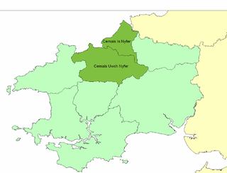
Cemais was an ancient cantref of the Kingdom of Dyfed, from the 11th century a Norman Marcher Lordship, from the 16th century a Hundred, and is now part of Pembrokeshire, Wales. It occupied the coastal area between the Teifi estuary and Fishguard, and the northern and southern slopes of the Preseli Hills, covering an area of approximately 140 square miles (360 km2). The Afon Nyfer divided it into two commotes: Cemais Is Nyfer to the north and Cemais Uwch Nyfer to the south.

Llanfyrnach Rural District was an administrative division of Pembrokeshire, Wales.
St Dogmells was a rural district in the administrative county of Pembrokeshire, Wales from 1894 to 1934.

Rhayader was, from 1894 to 1974, a rural district in the administrative county of Radnorshire, Wales.
Sibu Rural District Council is a local authority which administers Sibu rural areas such as Sibu Jaya and Selangau District. The agency is under the purview of Ministry of Local Government & Housing Sarawak (MLGH). The establishment of this council is to provide basic amenities, public infrastructure, and professional services to the population under its jurisdiction.

Cemaes Head is a headland and nature reserve in north Pembrokeshire. It lies in the community of St Dogmaels, within the Pembrokeshire Coast National Park. To the west and north it overlooks Cardigan Bay, and to the east Cardigan Island and the estuary of the River Teifi.