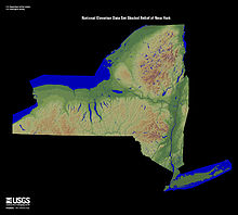
Albany County is a county in the state of New York, United States. Its northern border is formed by the Mohawk River, at its confluence with the Hudson River, which is to the east. As of the 2020 United States Census, the population was 314,848. The county seat and largest city is Albany, which is also the state capital of New York. As originally established by the English government in the colonial era, Albany County had an indefinite amount of land, but has had an area of 530 square miles (1,400 km2) since March 3, 1888. The county is named for the Duke of York and of Albany, who became James II of England.

Schenectady is a city in Schenectady County, New York, United States, of which it is the county seat. As of the 2020 census, the city's population of 67,047 made it the state's ninth-largest city by population. The city is in eastern New York, near the confluence of the Mohawk and Hudson rivers. It is in the same metropolitan area as the state capital, Albany, which is about 15 miles (24 km) southeast.
Schenectady County is a county in the U.S. state of New York. As of the 2020 census, the population was 158,061. The county seat is Schenectady. The name is from a Mohawk language word meaning "on the other side of the pine lands," a term that originally applied to Albany.

Colonie is a town in Albany County, New York, United States. It is the most-populous suburb of Albany, and is the third-largest town in area in Albany County, occupying approximately 11% of the county. Several hamlets exist within the town. As of the 2020 census, the town had a total population of 85,590.

Niskayuna is a town in Schenectady County, New York, United States. The population was 23,278 at the 2020 census. The town is located in the southeast part of the county, east of the city of Schenectady, and is the easternmost town in the county.

The Capital District, also known as the Capital Region, is the metropolitan area surrounding Albany, the capital of the U.S. state of New York. The Capital District was first settled by the Dutch in the early 17th century and came under English control in 1664. Albany has been the permanent capital of the state of New York since 1797. The Capital District is notable for many historical events that predate the independence of the United States, including the Albany Plan of Union and the Battles of Saratoga.

New York State Route 2 (NY 2) is a state highway in the Capital District of New York in the United States. It extends for 30.89 miles (49.71 km) from an interchange with Interstate 87 (I-87) and NY 7 in the town of Colonie to the Massachusetts state line in Petersburgh, where it continues to Boston as Massachusetts Route 2. The route passes through the cities of Watervliet and Troy, where it connects to NY 32 and U.S. Route 4, respectively. In Grafton, located midway between Troy and Massachusetts, NY 2 serves Grafton Lakes State Park.
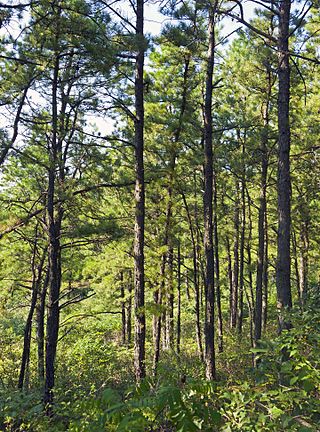
The Albany Pine Bush, referred to locally as the Pine Bush, is one of the largest of the 20 inland pine barrens in the world. It is centrally located in New York's Capital District within Albany and Schenectady counties, between the cities of Albany and Schenectady. The Albany Pine Bush was formed thousands of years ago, following the drainage of Glacial Lake Albany.
Latham is a hamlet in Albany County, New York, United States. It is located along U.S. Route 9 in the town of Colonie, a dense suburb north of Albany. As of the 2010 census, the population was 20,736. Latham was a census-designated place in the 1970, 1980, and 1990 US Censuses, but ceased to be in the 2000 Census, then became a CDP again in 2020.
Boght Corners is a hamlet in the town of Colonie in northern Albany County, New York, United States, that straddles U.S. Route 9. The corners that give the hamlet its name are found at the intersection of Route 9 and Boght Road, near the Boght Community Fire District's station. The community is served by the North Colonie Central School District. Boght Hills Elementary School is located within the hamlet.
Crescent Station is a hamlet of the town of Colonie in Albany County, New York, United States that straddles US Route 9.
Verdoy, formerly known as Watervliet Center, is a hamlet of the town of Colonie in Albany County, New York, United States. Much of Verdoy is in the Airport Noise Overlay District due to its immediate proximity to Albany International Airport's main north/south runway, which was recently extended by 1,300 feet to the north, moving it even closer to Verdoy. The former Troy & Schenectady Branch of the New York Central Railroad runs along Verdoy's northern border with the Mohawk River; it is now part of the Mohawk Hudson Hike/Bike Trail.

New York State Route 146 (NY 146) is a state highway in the Capital District of New York in the United States. It extends for 43 miles (69 km) from Gallupville at NY 443 to near Mechanicville at U.S. Route 4 (US 4) and NY 32. NY 146 is a major thoroughfare in the city of Schenectady, just outside Albany. Most of the route follows an east–west alignment; however, the middle third of the route between Guilderland and Clifton Park runs in a more north–south manner in order to serve Schenectady. At one time, NY 146 had three spur routes; only one—NY 146A—still exists.

The Mohawk Towpath Scenic Byway is a National Scenic Byway in the Capital District region of New York in the United States. It extends from Schenectady to Waterford by way of a series of local, county, and state highways along the Mohawk River and the Erie Canal. The byway is intended to showcase the history of the waterway, from Native American times through the creation of the Erie Canal and the role the waterside communities played in the Industrial Revolution and the westward expansion of the United States. At its east end, the byway connects to the Lakes to Locks Passage, an All-American Road.
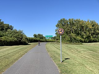
The Mohawk-Hudson Bike-Hike Trail (MHBHT) is a 97-mile (156 km) trail in New York's Mohawk Valley and Capital District regions. It is also the easternmost segment of the Erie Canalway Trail, as well as a portion of the Empire State Trail.
Watervliet was a town that at its height encompassed most of present-day Albany County and most of the current town of Niskayuna in neighboring Schenectady County, in the state of New York, United States. Just prior to its dissolution, the town encompassed the current towns of Colonie and Green Island and the city of Watervliet.
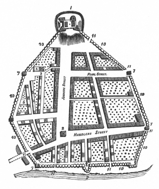
The streets of Albany, New York have had a long history going back almost 400 years. Many of the streets have changed names over the course of time, some have changed names many times. Some streets no longer exist, others have changed course. Some roads existed only on paper. The oldest streets were haphazardly laid out with no overall plan until Simeon De Witt's 1794 street grid plan. The plan had two grids, one west of Eagle Street and the old stockade, and another for the Pastures District south of the old stockade.
Lisha Kill is a hamlet in the town of Colonie, Albany County, New York, United States. Lisha Kill lies on New York Route 5 in the western section of the town. The hamlet received its name from the creek of the same name, Lisha Kill, kill being Dutch for creek or stream. The stream is also referred to as Lisha's Kill and received its name from a local legend about a Native American woman who is buried along its banks.
Roessleville is a hamlet in the town of Colonie, Albany County, New York, United States. It is a densely settled suburb of the city of Albany, along New York State Route 5. Roessleville was a census-designated place in the 1990 Census, but was deleted in 2000, but became a CDP again in 2020.
The history of Albany, New York from 1784 to 1860 begins with the ratification of the Treaty of Paris by the Congress of the Confederation in 1784 and ends in 1860, prior to the American Civil War.