Central Canadian Shield forests

Last updated
Central Canadian Shield forests
Pukaskwa National Park southern headland trail.JPG
Central Canadian Shield forests map.svg
Ecology
Realm Nearctic
Biome Boreal forests/taiga
Borders
Geography
Area461,795 km2 (178,300 sq mi)
Country Canada
Provinces
Conservation
Conservation status Vulnerable [1]

The Central Canadian Shield forests are a taiga ecoregion of Eastern Canada, as defined by the World Wildlife Fund (WWF) categorization system. [1]

Contents

Setting

This ecoregion consists of rolling hills, lakes, bogs and rocky outcrops covering a large curved swathe on the Canadian Shield from the Echoing River in Northern Ontario, running southeastwards through Thunder Bay District to the north shore of Lake Superior and then northeastwards into western Quebec. The area has a cool climate with summer temperatures averaging around 13°C dropping to a very cold -17°C in winter, with the hills around Lac Seul in northwestern Ontario being warmer and wetter than most of the area. Average rainfall in the eastern side of the ecoregion is 550mm per year, rising to 750mm in the centre (near Lake Nipigon for example), up to 900mm in the west. Specific areas include Lake Nipigon and Big Trout Lake (Ontario). [2] These forest contrast with more severe boreal forest ecoregions such as the Eastern Canadian Shield taiga to the north, which covers most of Northern Quebec and Labrador.

Flora

Pukaskwa National Park in Ontario. Pukaskwa National Park.jpg
Pukaskwa National Park in Ontario.

These hills support a large area of rich taiga forest dominated by black spruce ( Picea mariana ) along with jack pine and some paper birch ( Betula papyrifera ) and in the warmer south-facing areas some trembling aspen ( Populus tremuloides ), white spruce ( Picea glauca ), Ontario balsam poplar ( Populus balsamifera ) and balsam fir ( Abies balsamea ). Many of the rocks of the area are covered with colourful lichens. The ecoregion contains large areas of wetland especially in the south east, and a greater variety of plant life on the north shore of Lake Superior.

Fauna

Mammals of the taiga include moose ( Alces alces ), the southernmost populations of migratory woodland caribou ( Rangifer tarandus caribou ), American black bear ( Ursus americanus ), Canada lynx ( Lynx canadensis ), snowshoe hare ( Lepus americanus ) and grey wolf ( Canis lupus ). Birds of the area include northern hawk owl ( Surnia ulula ), great horned owl ( Bubo virginianus ), sharp-tailed grouse ( Tympanuchus phasianellus ), ruffed grouse ( Bonasa umbellus ), American black duck ( Anas rubripes ), wood duck ( Aix sponsa ), Canada goose ( Branta canadensis ) in the north, and hooded merganser ( Lophodytes cucullatus ) and pileated woodpecker ( Dryocopus pileatus ) in the west.

Threats and preservation

This is fairly well-preserved ecoregion with 40% of original forest intact (less so in Manitoba) while most has been heavily changed by logging and in some areas by mining and hydroelectric power generation. Large blocks of undisturbed forest do remain, for example north of Lake Nipigon in Ontario and around Lake Mistassini in Quebec, and in the following protected areas: Wabakimi Provincial Park northwest of Lake Nipigon, Pukaskwa National Park near Marathon, Ontario on the Lake Superior shore, a number of rivers and lakes in Northern Ontario (Winisk River, Missinaibi River, Albany River north of Wabakimi Park, Severn River (northern Ontario), Attawapiskat Lake/Attawapiskat River and Brightsand River), Kesagami Provincial Park, Michipicoten Island in Lake Superior, all in Ontario; and Aiguebelle National Park in Quebec.

See also

Related Research Articles

<span class="mw-page-title-main">British Columbia mainland coastal forests</span> Temperate coniferous forest ecoregion in British Columbia, Canada and Washington, United States

British Columbia mainland coastal forests is a temperate coniferous forest ecoregion the Pacific coast of North America, as defined by the World Wildlife Fund (WWF) categorization system.

<span class="mw-page-title-main">New England–Acadian forests</span> Temperate broadleaf and mixed forest ecoregion of Canada and the United States

The New England-Acadian forests are a temperate broadleaf and mixed forest ecoregion in North America that includes a variety of habitats on the hills, mountains and plateaus of New England and New York State in the Northeastern United States, and Quebec and the Maritime Provinces of Eastern Canada.

<span class="mw-page-title-main">Eastern forest–boreal transition</span> Temperate broadleaf and mixed forest ecoregion in Canada and the United States

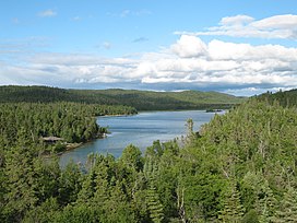
The eastern forest–boreal transition is a temperate broadleaf and mixed forests ecoregion of North America, mostly in eastern Canada. It is a transitional zone or region between the predominantly coniferous Boreal Forest and the mostly deciduous broadleaf forest region further south.

<span class="mw-page-title-main">Eastern Great Lakes lowland forests</span> Temperate broadleaf and mixed forest ecoregion of Canada and the United States

The Eastern Great Lakes lowland forests is a temperate broadleaf and mixed forest ecoregion of North America, as defined by the World Wildlife Fund. It lies mostly in south and eastern Ontario and Quebec in Canada, and Upstate New York and Vermont in the United States.

<span class="mw-page-title-main">Gulf of St. Lawrence lowland forests</span> Temperate broadleaf and mixed forest ecoregion of Canada and the United States

The Gulf of St. Lawrence lowland forests are a temperate broadleaf and mixed forest ecoregion of Eastern Canada, as defined by the World Wildlife Fund (WWF) categorization system.

<span class="mw-page-title-main">Alberta Mountain forests</span> Temperate coniferous forests ecoregion of Alberta and British Columbia, Canada

The Alberta Mountain forests are a temperate coniferous forests ecoregion of Western Canada, as defined by the World Wildlife Fund (WWF) categorization system.

<span class="mw-page-title-main">Alberta–British Columbia foothills forests</span> Temperate coniferous forests ecoregion of Alberta and British Columbia, Canada

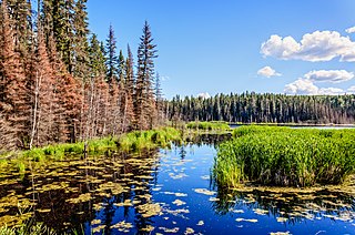
The Alberta–British Columbia foothills forests are a temperate coniferous forests ecoregion of Western Canada, as defined by the World Wildlife Fund (WWF) categorization system. This ecoregion borders Canada's taiga and contains a mix of subarctic forest and temperate forest species as a result. This makes the region an ecotone region, or a region that acts as a buffer between two other biomes.

<span class="mw-page-title-main">Eastern Canadian Boreal Forests</span> Taiga ecoregion of eastern Canada

The Eastern Canadian Boreal Forests is a boreal ecoregion in Eastern Canada, defined by the One Earth ecoregion categorization system.

<span class="mw-page-title-main">Eastern Canadian Shield taiga</span> Taiga ecoregion of Labrador and Quebec, Canada

The Eastern Canadian Shield taiga is an ecoregion of Canada as defined by the World Wildlife Fund (WWF) categorization system.

<span class="mw-page-title-main">Yukon Interior dry forests</span> Taiga ecoregion of British Columbia and Yukon, Canada

The Yukon Interior dry forests is a taiga ecoregion of Canada.

<span class="mw-page-title-main">Muskwa–Slave Lake Taiga</span> Taiga ecoregion of northwestern Canada

The Muskwa-Slave Lake Taiga ecoregion covers Canadian taiga in northwestern Alberta, northeastern British Columbia and a large portion of the southwestern Northwest Territories around the Mackenzie River valley and the Great Slave Lake.

<span class="mw-page-title-main">South Central Rockies forests</span> Temperate coniferous forests ecoregion of the United States

The South Central Rockies forests is a temperate coniferous forest ecoregion of the United States located mainly in Wyoming, Idaho, and Montana. It has a considerably drier climate than the North Central Rockies forest.

<span class="mw-page-title-main">Interior Alaska–Yukon lowland taiga</span> Taiga ecoregion of Canada and the United States

The interior Alaska–Yukon lowland taiga is an ecoregion in the taiga and boreal forests biome, of far northern North America.

<span class="mw-page-title-main">Mid-Canada Boreal Plains Forests</span> Taiga ecoregion of western Canada

The Mid-Canada Boreal Plains Forests is a taiga ecoregion of Western Canada, designated by One Earth. It was previously defined as the Mid-Continental Canadian Forests by the World Wildlife Fund (WWF) categorization system, before it was modified by One Earth, the successor to WWF.

<span class="mw-page-title-main">Midwest Canadian Shield Forests</span> Taiga ecoregion of Canada

The Midwest Canadian Shield Forests is an ecoregion in Canada, classified as a Taiga and Boreal Forests Biome.

<span class="mw-page-title-main">Western Great Lakes forests</span> Temperate broadleaf and mixed forest ecoregion in Canada and the United States

The Western Great Lakes forests is a terrestrial ecoregion as defined by the World Wildlife Fund. It is within the temperate broadleaf and mixed forests biome of North America. It is found in northern areas of the United States' states of Michigan, Wisconsin and Minnesota, and in southern areas of the Canadian province of Manitoba and northwestern areas of the province of Ontario.

<span class="mw-page-title-main">Southern Great Lakes forests</span> Temperate broadleaf and mixed forests ecoregion of Canada and the United States

The Southern Great Lakes lowland forests is a temperate broadleaf and mixed forest ecoregion of North America, as defined by the World Wildlife Fund. Located near the Great Lakes, it lies mostly in the central northeastern United States and extends into southeast central Canada. In modern times, little of it remains intact due to land use, including agriculture and urban uses.

<span class="mw-page-title-main">Southern Hudson Bay taiga</span> Taiga ecoregion of Canada

The Southern Hudson Bay taiga is a terrestrial ecoregion, as classified by the World Wildlife Fund, which extends along the southern coast of Hudson Bay and resides within the larger taiga biome. The region is nearly coterminous with the Hudson Plain, a Level I ecoregion of North America as designated by the Commission for Environmental Cooperation (CEC) in its North American Environmental Atlas.

<span class="mw-page-title-main">Northwest Territories taiga</span> Taiga ecoregion located in the Northwest Territories and Yukon provinces of Canada

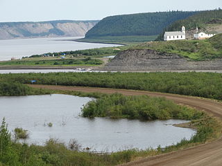
The Northwest Territories taiga ecoregion (WWF:NA0614) is located in the Northwest Territories and Yukon provinces of Canada. It covers forest and tundra along the Mackenzie River Valley and the surrounding highlands in the southern portion of the valley.

<span class="mw-page-title-main">Low Arctic tundra</span> Tundra ecoregion of Canada

The Canadian Low Arctic Tundra ecoregion covers a rolling landscape of shrubby tundra vegetation along the northern edge of the mainland Canada along the border of the Northwest Territories and Nunavut, and a small portion in Quebec on the northeast coast of Hudson Bay. The region is important for large herds of caribou and other large mammals, and for large nesting colonies of birds such as snow geese. The region is mostly intact, with 95% remaining intact.

References

  1. 1 2 "Northern Canadian Shield taiga - Ecoregions - WWF".
  2. "Central Canadian Shield forests". Terrestrial Ecoregions. World Wildlife Fund.

Central Canadian Shield Forests. One Earth