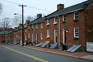
Oella is a mill town on the Patapsco River in western Baltimore County, Maryland, United States, located between Catonsville and Ellicott City. It is a 19th-century village of millworkers' homes.

The Community College of Baltimore County (CCBC) is a public community college in Baltimore County, Maryland with three main campuses and three extension centers.

St. Charles College was a minor seminary in Catonsville, Maryland, originally located in Ellicott City, Maryland.

The Cray House is a two-room house in Stevensville, Maryland. Built around 1809, it is a rare surviving example of post-and-plank construction, and of a build of small house which once dominated the local landscape. For these reasons it was listed on the National Register of Historic Places in 1983.
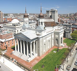
The Cathedral Hill Historic District is an area in Baltimore, Maryland. It lies in the northern part of Downtown just south of Mount Vernon. Roughly bounded by Saratoga Street, Park Avenue, Hamilton Street, and St. Paul Street, these 10 or so blocks contain some of the most significant buildings in Baltimore. The area takes its name from the Basilica of the Assumption which sits in the heart of the district. Despite the number of large religious structures in the area, the district's buildings are primarily commercial in character, with a broad collection of significant commercial structures ranging in date from 1790 to 1940.

Brooklandville House, or the Valley Inn, is a historic restaurant and tavern building, and a former inn, located in Brooklandville, Baltimore County, Maryland. It is a 2+1⁄2-story stone structure facing the former railroad and dating from about 1832. It is associated with the Baltimore and Susquehanna Railroad, which crossed the property just to the south.

Hilton is a historic home located at The Community College of Baltimore County in Catonsville, Baltimore County, Maryland. It is an early-20th-century Georgian Revival–style mansion created from a stone farmhouse built about 1825, overlooking the Patapsco River valley. The reconstruction was designed by Baltimore architect Edward L. Palmer, Jr. in 1917. The main house is five bays in length, two and a half stories above a high ground floor, with a gambrel roof. The house has a 2+1⁄2-story wing, five bays in length, with a gabled roof, extending from the east end; and a two-story, one-bay west wing. The roof is covered with Vermont slate. The house features a small enclosed porch of the Tuscan order that was probably originally considered a porte cochere.
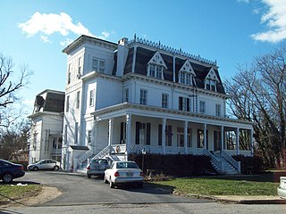
Summit is a historic home located in Catonsville, Baltimore County, Maryland. It a large brick house, once part of a country estate owned by James Albert Gary. It features a three-story Italianate tower and large wing extending to the rear. The main façade is three stories and five bays wide, with the tower located on the east side. A one-story porch with square columns and railings runs across the full façade. The mansion was built originally as a summer home and later converted to apartments after its sale to the Summit Park Company in 1919.
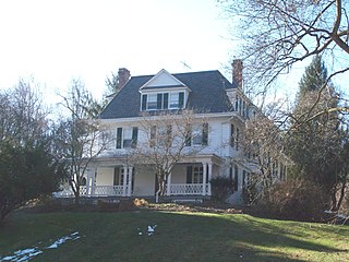
The Wilderness is a historic home located near Catonsville, Baltimore County, Maryland. It is a large stone and frame house located in a wooded setting west of Catonsville. The original home was built about 1800, and it attained its current appearance following a major expansion in 1899–1900, when it was a summer residence of Francis Cumberland Dugan II (1830-1914). It features multiple roof and dormer shapes and a wraparound porch reminiscent of the Queen Anne style. The third story is located within a tall mansard roof. Also on the property are a stone springhouse / smokehouse, a summer kitchen, log tenant house, and a large frame barn.

Old Catonsville High School, also known as St. Mark's School, is a historic school building located at Catonsville, Baltimore County, Maryland. It is a masonry schoolhouse which consists of a one-story, single bay structure and a three-story, four bay addition. In 1885 the school was designated a high school and in 1910 the property was sold to the Catholic Church.

National Enameling and Stamping Company is a historic factory complex located at Baltimore, Maryland, United States. It was constructed in 1887 to serve as the works of the Baltimore branch of the nation's largest tinware manufacturer, the National Enameling and Stamping Company (NESCO). The densely packed complex fills an almost 5-acre (2.0 ha) site and consists of 17 interconnected buildings and one structure that vary in height from one to five stories. The complex was organized to house three primary functions in discrete sections: the manufacture of tinware, the manufacture of enameled and japanned wares, and storage, warehousing, and distribution. The plant ceased production of tinware and enameled wares in 1952.

Oakenshawe Historic District is a national historic district in Baltimore, Maryland, United States. It comprises 334 buildings which reflect the neighborhood's development during the period 1890 to about 1926. The neighborhood evolved in two stages on the 19th century Wilson estate. The first phase of growth is represented by frame houses dating from 1890 to about 1910 reflecting vernacular interpretations of the Victorian Gothic and Italianate styles. The second stage of development began in the World War I era, when several developers transformed the property by constructing a neighborhood of brick "daylight" rowhouses in revival styles popular at the time.

Franklintown Historic District is a national historic district in Baltimore, Maryland, United States. It is the result of a plan developed in 1832 by William H. Freeman (1790–1863), a local politician and entrepreneur. His plan evolved gradually over the course of several decades and owes its success to his untiring promotion of the village. The central feature is an oval plan with radiating lots around a central wooded park. The district includes an old stone grist mill known as Franklin Mill, the innovative radiating oval plan, and the associated hotel and commercial area. The key residential buildings are excellent examples of the "I"-house form and display steeply pitched cross gables found in vernacular rural buildings throughout much of Maryland.

Old Catonsville Historic District is a national historic district in Catonsville, Baltimore County, Maryland, United States. It was laid out with the construction of the electric railway and is overwhelmingly residential, with three churches, a modern public library, and an Art Deco water tower. Architectural styles in the district range from mid- to late-19th century vernacular "I-houses" to late-19th and early-20th century styles such as Queen Anne, Bungalow, Colonial Revival, Dutch Colonial, Tudor Revival, and Craftsman. A large number of these dwellings have freestanding garages, typically finished in a like manner to their houses.
Corbett Historic District is a national historic district at Monkton, Baltimore County, Maryland, United States. It is a group of 20 dwellings, a doctor's office, a former store/post office, a brothel, and a school comprising the village of Corbett in rural northern Baltimore County, Maryland. Most of the buildings date from about 1880 through about 1920. They reflect the period of Corbett's development as a stop on the Northern Central Railway, and a local commercial, industrial, and transportation center for the surrounding farms.

Lutherville Historic District is a national historic district at Lutherville, Baltimore County, Maryland, United States. It is an irregularly shaped urban entity founded in 1852 as a summer resort and suburb of Baltimore City. Single-family dwellings on large lots characterize the community and most of the structures predate World War I, although ranch-type and "colonial" houses have appeared in the past few decades.

Reisterstown Historic District is a national historic district in Reisterstown, Baltimore County, Maryland, United States. Its development is inseparably identified with the roads that converge to form Main Street. They are Maryland Route 30 and Maryland Route 140. The earliest structures, including several of log, date to the late 18th century, although the town was founded in 1758. It developed as a convenient stopping place for weary travelers from the outer reaches of Western Maryland or Pennsylvania and many businesses catered to the traveler: including taverns and inns, smithshops, saddleries, stables, waggoners.

Winters Lane Historic District is a national historic district at Catonsville, Baltimore County, Maryland, United States. It is a historically African-American residential community which developed between 1867 and the mid-1940s. Winters Lane is located between Frederick Road and the Baltimore National Pike. It is composed mainly of single-family dwellings augmented by a few commercial, social, or religious resources. The district contains 155 properties, including 141 residential properties, two former schools, three commercial buildings, three social clubs, and five churches or church-related buildings.

Worthington Valley Historic District is a national historic district in Reisterstown, Baltimore County, Maryland, United States. It is a largely rural district where the earliest standing structures date from the very end of the 18th century. Horse breeding and racing is a very large and lucrative business in the valley. Since 1922, Snow Hill and Worthington Farms have been the scene of the Maryland Hunt Cup Steeplechase. Located next to it is the Western Run–Belfast Road Historic District.

The Bare Hills Historic District encompasses a residential area north of Baltimore, Maryland, in Baltimore County, which had industrial beginnings before being transformed into a suburb of the city. The district includes Lake Roland Park as well as a cluster of largely vernacular dwellings between the park and Falls Turnpike that was built mainly in the 19th century.


