Related Research Articles

Pluto is a dwarf planet in the Kuiper belt, a ring of bodies beyond the orbit of Neptune. It is the ninth-largest and tenth-most-massive known object to directly orbit the Sun. It is the largest known trans-Neptunian object by volume, by a small margin, but is less massive than Eris. Like other Kuiper belt objects, Pluto is made primarily of ice and rock and is much smaller than the inner planets. Pluto has roughly one-sixth the mass of Earth's moon, and one-third its volume.

Charon, known as (134340) Pluto I, is the largest of the five known natural satellites of the dwarf planet Pluto. It has a mean radius of 606 km (377 mi). Charon is the sixth-largest known trans-Neptunian object after Pluto, Eris, Haumea, Makemake, and Gonggong. It was discovered in 1978 at the United States Naval Observatory in Washington, D.C., using photographic plates taken at the United States Naval Observatory Flagstaff Station (NOFS).

Hellas Planitia is a plain located within the huge, roughly circular impact basin Hellas located in the southern hemisphere of the planet Mars. Hellas is the third- or fourth-largest known impact crater in the Solar System. The basin floor is about 7,152 m (23,465 ft) deep, 3,000 m (9,800 ft) deeper than the Moon's South Pole-Aitken basin, and extends about 2,300 km (1,400 mi) east to west. It is centered at 42.4°S 70.5°E. Hellas Planitia spans the boundary between the Hellas quadrangle and the Noachis quadrangle.

A cryovolcano is a type of volcano that erupts gases and volatile material such as liquid water, ammonia, and hydrocarbons. The erupted material is collectively referred to as cryolava; it originates from a reservoir of subsurface cryomagma. Cryovolcanic eruptions can take many forms, such as fissure and curtain eruptions, effusive cryolava flows, and large-scale resurfacing, and can vary greatly in output volumes. Immediately after an eruption, cryolava quickly freezes, constructing geological features and altering the surface.
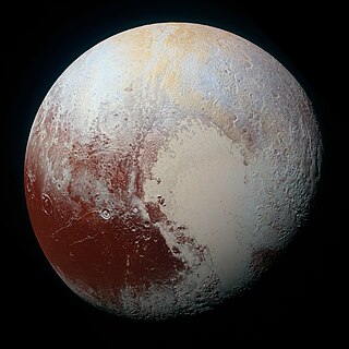
The geology of Pluto consists of the characteristics of the surface, crust, and interior of Pluto. Because of Pluto's distance from Earth, in-depth study from Earth is difficult. Many details about Pluto remained unknown until 14 July 2015, when New Horizons flew through the Pluto system and began transmitting data back to Earth. When it did, Pluto was found to have remarkable geologic diversity, with New Horizons team member Jeff Moore saying that it "is every bit as complex as that of Mars". The final New Horizons Pluto data transmission was received on 25 October 2016. In June 2020, astronomers reported evidence that Pluto may have had a subsurface ocean, and consequently may have been habitable, when it was first formed.
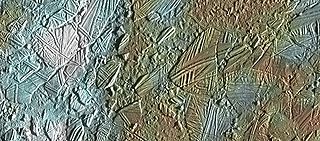
In astrogeology, chaos terrain, or chaotic terrain, is a planetary surface area where features such as ridges, cracks, and plains appear jumbled and enmeshed with one another. Chaos terrain is a notable feature of the planets Mars and Mercury, Jupiter's moon Europa, and the dwarf planet Pluto. In scientific nomenclature, "chaos" is used as a component of proper nouns.

The atmosphere of Pluto is the layer of gasses that surround the dwarf planet Pluto. It consists mainly of nitrogen (N2), with minor amounts of methane (CH4) and carbon monoxide (CO), all of which are vaporized from surface ices on Pluto's surface. It contains layered haze, probably consisting of heavier compounds which form from these gases due to high-energy radiation. The atmosphere of Pluto is notable for its strong and not completely understood seasonal changes caused by peculiarities of the orbital and axial rotation of Pluto.
Scalloped topography is common in the mid-latitudes of Mars, between 45° and 60° north and south. It is particularly prominent in the region of Utopia Planitia, in the northern hemisphere, and in the region of Peneus and Amphitrites Paterae in the southern hemisphere. Such topography consists of shallow, rimless depressions with scalloped edges, commonly referred to as "scalloped depressions" or simply "scallops". Scalloped depressions can be isolated or clustered and sometimes seem to coalesce. A typical scalloped depression displays a gentle equator-facing slope and a steeper pole-facing scarp. This topographic asymmetry is probably due to differences in insolation. Scalloped depressions are believed to form from the removal of subsurface material, possibly interstitial ice, by sublimation. This process may still be happening at present. This topography may be of great importance for future colonization of Mars because it may point to deposits of pure ice.

Elysium Planitia, located in the Elysium and Aeolis quadrangles, is a broad plain that straddles the equator of Mars, centered at 3.0°N 154.7°E. It lies to the south of the volcanic province of Elysium, the second largest volcanic region on the planet, after Tharsis. Elysium contains the major volcanoes Elysium Mons, Albor Tholus and Hecates Tholus. Another more ancient shield volcano, Apollinaris Mons, is situated just to the south of eastern Elysium Planitia. Within the plains, Cerberus Fossae is the only Mars location with recent volcanic eruptions. Lava flows dated no older than 0.2 million years from the present have been found, and evidence has been found that volcanic activity may have occurred as recently as 53,000 years ago. Such activity could have provided the environment, in terms of energy and chemicals, needed to support life forms.

Tombaugh Regio, sometimes nicknamed "Pluto's heart" after its shape, is the largest bright surface feature of the dwarf planet Pluto. It lies just north of Pluto's equator, to the northeast of Belton Regio and to the northwest of Krun Macula, which are both dark features. Its western lobe, a 1,000 km (620 mi)-wide plain of nitrogen and other ices lying within a basin, is named Sputnik Planitia. The eastern lobe consists of high-albedo uplands thought to be coated by nitrogen transported through the atmosphere from Sputnik Planitia, and then deposited as ice. Some of this nitrogen ice then returns to Sputnik Planitia via glacial flow. The region is named after Clyde Tombaugh, the discoverer of Pluto.

Belton Regio is a prominent surface feature of the dwarf planet Pluto. It is an elongated dark region along Pluto's equator, 2,990 km (1,860 mi) long and one of the darkest features on its surface.

The geology of Charon encompasses the characteristics of the surface, crust, and interior of Pluto's moon Charon. Like the geology of Pluto, almost nothing was known of Charon's geology until the New Horizons of the Pluto system on 14 July 2015. Charon's diameter is 1,208 km (751 mi)—just over half that of Pluto. Charon is sufficiently massive to have collapsed into a spheroid under its own gravity.

The geography of Pluto is mainly focused the distribution of physical features across Pluto. On 14 July 2015, the New Horizons spacecraft became the first spacecraft to fly by Pluto. During its brief flyby, New Horizons made detailed geographical measurements and observations of Pluto and its moons.

Sputnik Planitia is a large, partially glaciated basin on Pluto. About 1,400 by 1,200 km in size, Sputnik Planitia is partially submerged in large, bright glaciers of nitrogen ice. Named after Earth's first artificial satellite, Sputnik 1, it constitutes the western lobe of the heart-shaped Tombaugh Regio. Sputnik Planitia lies mostly in the northern hemisphere, but extends across the equator. Much of it has a surface of irregular polygons separated by troughs, interpreted as convection cells in the relatively soft nitrogen ice. The polygons average about 33 km (21 mi) across. In some cases troughs are populated by blocky mountains or hills, or contain darker material. There appear to be windstreaks on the surface with evidence of sublimation. The dark streaks are a few kilometers long and all aligned in the same direction. The planitia also contains pits apparently formed by sublimation. No craters were detectable by New Horizons, implying a surface less than 10 million years old. Modeling sublimation pit formation yields a surface age estimate of 180000+90000
−40000 years. Near the northwest margin is a field of transverse dunes, spaced about 0.4 to 1 km apart, that are thought to be composed of 200-300 μm diameter particles of methane ice derived from the nearby Al-Idrisi Montes.

The Coleta de Dados Colles are a cluster of hills ("colles") on the smooth plains of Sputnik Planitia on Pluto. The hills are over 100 km from the major mountain ranges to the west, and appear to be blocks of water ice floating in the denser nitrogen ice of Sputnik Planitia. The hills were informally named on July 28, 2015, by the research team of the New Horizons mission after the first Brazilian satellite, the Satélite de Coleta de Dados. The ridge's name has yet to be recognized officially by the IAU.

Wright Mons is a large, roughly circular mountain and likely cryovolcano on the dwarf planet Pluto. Discovered by the New Horizons spacecraft in 2015, it is located southwest of Sputnik Planitia within Hyecho Palus, adjacent to the Tenzing Montes and Belton Regio. A relatively young geological feature, Wright Mons has attracted attention as one of the most apparent examples of recent geological activity on Pluto and borders numerous other similarly young features. Numerous semi-regular hills surround and partially construct the flanks of Wright Mons. Their nature remains unexplained, with few, if any, direct analogs elsewhere in the Solar System.

Mandjet Chasma is a chasma on Pluto's moon, Charon. Mandjet Chasma is 385 km (239 mi) long, and about 5–7 km (3.1–4.3 mi) deep with an average width of 30 km (19 mi). The chasma is part of a global tectonic belt: a series of canyons, scarps, and troughs that traverse the face of Charon along the northern edge of Vulcan Planum. The feature was discovered using stereoscopic processing of New Horizons images.

Serenity Chasma is the unofficial name given to a large pull-apart fault on Pluto's moon, Charon. It is part of a series of faults that run along the perimeter of Vulcan Planum. It was discovered by the New Horizons mission, and informally named after the fictitious spaceship, Serenity.

The climate of Pluto concerns the atmospheric dynamics, weather, and long-term trends on the dwarf planet Pluto. Five climate zones are assigned on the dwarf planet: tropics, arctic, tropical arctic, diurnal, and polar. These climate zones are delineated based on astronomically defined boundaries or sub-solar latitudes, which are not associated with the atmospheric circulations on the dwarf planet. Charon, the largest moon of Pluto, is tidally locked with it, and thus has the same climate zone structure as Pluto itself.
References
- 1 2 "Challenger Colles". Gazetteer of Planetary Nomenclature. USGS Astrogeology Research Program. (Center Latitude: 23.05°, Center Longitude: 195.10°)
- 1 2 3 4 Howard, Alan D.; Moore, Jeffrey M.; Umurhan, Orkan M.; et al. (May 2017). "Present and past glaciation on Pluto". Icarus. 287: 287-300. Bibcode:2017Icar..287..287H. doi:10.1016/j.icarus.2016.07.006.
- ↑ Talbert, Tricia (4 February 2016). "Pluto's Mysterious, Floating Hills". nasa.gov. NASA . Retrieved 28 May 2016.
- ↑ White, Oliver L.; Moore, Jeffrey M.; McKinnon, William B.; et al. (May 2017). "Geological mapping of Sputnik Planitia on Pluto". Icarus. 287: 261-286. Bibcode:2017Icar..287..261W. doi:10.1016/j.icarus.2017.01.011.
| Geography (features) |
|   | |||||||||||||
|---|---|---|---|---|---|---|---|---|---|---|---|---|---|---|---|
| Moons |
| ||||||||||||||
| Astronomy |
| ||||||||||||||
| Exploration |
| ||||||||||||||
| Related | |||||||||||||||
| | This article about an extraterrestrial geological feature is a stub. You can help Wikipedia by expanding it. |