
Flitwick is a town and civil parish in Bedfordshire, England. It is mentioned in the Domesday Book of 1086 as "a hamlet on the River Flitt". The spelling Flytwyk appears in 1381.
Rowland's Castle is a village and civil parish in the East Hampshire district of Hampshire, England. It is 2.9 miles (4.7 km) north of Havant, on the Hampshire/West Sussex border.

Toddington is a large village and civil parish in the county of Bedfordshire, England. It is situated 5 miles north-north-west of Luton, 4 miles (6 km) north of Dunstable, 6 miles (10 km) south-west of Woburn, and 35 miles north-north-west of London on the B5120 and B579. It is 0.5 miles from Junction 12 of the M1 motorway and lends its name to the nearby motorway service station. The hamlet of Fancott also forms part of the Toddington civil parish.

Harlington is a village and civil parish located in Bedfordshire, England, near the M1 motorway. The nearest town is Flitwick about 3 miles (4.8 km) to the north.

Chalgrave is a civil parish in the Central Bedfordshire district of Bedfordshire, England. The hamlets of Tebworth and Wingfield are in the west of the parish, with the church and manor in the east. Nearby places are Toddington, Chalton, Houghton Regis, and Hockliffe. Before 1929, the parish also included part of the village of Hockliffe.

Heath and Reach is a village and civil parish near the Chiltern Hills in Bedfordshire, England. It is 2 miles (3.2 km) north of Leighton Buzzard and 3 miles (4.8 km) south of Woburn and adjoins the county boundary with Buckinghamshire. Nearby places are Leighton-Linslade, Great Brickhill and the Duke of Bedford's Woburn Abbey, Woburn Safari Park and Woburn Golf Club.

Clanfield is a village and civil parish in the south-east of the East Hampshire district of Hampshire, England. It is situated 2.4 miles north of Horndean, 12 mi (19 km) north of Portsmouth and 6 mi (10 km) south of Petersfield. It sits to the west of the main A3 road, just north of where the A3(M) (Motorway) ends.

Westoning is a village and civil parish in Bedfordshire, England. It is located around 0.5 miles (0.8 km) south of the town of Flitwick. The River Flit flows behind the Westoning stud farm.

Moggerhanger is a village in the English county of Bedfordshire. It is west of Sandy on the road to Bedford. Its population in 2001 was 636, but had reduced to 620 at the 2011 Census. In the twentieth century the village name was spelled variously as: Moggerhanger, Mogerhanger, Muggerhanger and Morehanger. Local pronunciation of the name is as Morhanger.

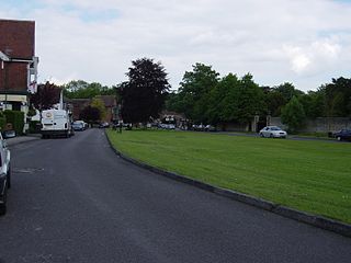
Chalton is a small village and former civil parish, now in the parish of Clanfield, in the East Hampshire district of Hampshire, England. It is 2.3 miles (3.7 km) north-east of Horndean and just east of the A3. The nearest railway station is 3.1 miles (5 km) south of the village, at Rowlands Castle. In 1931 the parish had a population of 158. On 1 April 1932 the parish was abolished and merged with Clanfield, part also went to form Rowlands Castle.

Langford is a village and civil parish in the Central Bedfordshire district of the county of Bedfordshire, England about 10 miles (16 km) south-east of the county town of Bedford. The 2011 census gives the population as 3,091.

Leagrave is a former village and now a suburb of Luton, in the Luton district, in the ceremonial county of Bedfordshire, England, in the northwest of the town. The current council ward is roughly bounded by Vincent Road, Torquay Drive and High Street to the north, Roman Road and Stoneygate Road to the south, the M1 to the west, and Marsh Road and Leagrave Park to the east.
Lewsey is a suburb of Luton, about 3 miles (4.8 km) west north-west of the town centre, and a ward of the Borough of Luton, in the ceremonial county of Bedfordshire, England. The suburb is roughly bounded by Leagrave High Street to the north, Dunstable Road to the south, Poynters Road, Dunstable to the west, and the M1 to the east.
Sundon is a civil parish in the English county of Bedfordshire.
Sundon Park is a suburb of north Luton, in the Luton district, in the ceremonial county of Bedfordshire, England. The area is roughly bounded by the edge of Luton to the north, Leagrave Park to the south, the Midland Main Line to the west, and Spinney Woods and the footpath from the woods to the edge of town to the east.
Lower Shelton is a village in the civil parish of Marston Moreteyne in Bedfordshire, England. It is made of Lower Shelton Road, Stratford Way, The Rickyard, Franklin Close and Chequers Close and another small close known locally as "The jetty" although there is no water in view. The area is made up of many sizes and types of houses of differing ages.

Sutton is a rural village and civil parish in the Central Bedfordshire district of Bedfordshire, England. It lies 11 miles (18 km) east of Bedford. At the 2001 Census, its population was 299. Main features are the packhorse bridge over the Potton Brook, the adjacent ford, and the Grade I listed All Saints' Parish Church.

Dunstable is a market town and civil parish in Bedfordshire, England, east of the Chiltern Hills, 30 miles north of London. There are several steep chalk escarpments, most noticeable when approaching Dunstable from the north. Dunstable is the fourth largest town in Bedfordshire and along with Houghton Regis forms the westernmost part of the Luton/Dunstable urban area.
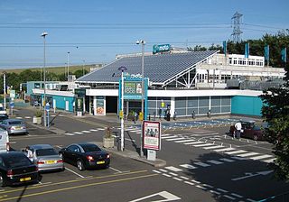
Toddington Services is a motorway service station on the M1 motorway between junctions 11A and 12, just north of Luton and Dunstable in Bedfordshire, England. It takes its name from the nearby village of Toddington. It is owned by Moto Hospitality.
Tophill is a suburb of Luton, in the north-west of the town, centred on Toddington Road, in Bedfordshire, England. It is roughly bounded by the edge of Luton to the north, Brickly Road to the south, the M1 to the west, and the Midland Main Line to the east.

